After 2 years of planning and a 2nd attempt to find it on the Delta, I finally found my Shipwreck! For now it’s the ‘Spud Island Shipwreck’ since there are no markings and I can’t find any information on it. It will officially be the ‘Spud Island Shipwreck’. On the way to the wreck #CaptainBonnie (Bonnie Nasworthy Jones) pointed out a sunken city. I call ‘Jones Track Ghost Town’, an abandoned sunken Ghost Town. It consists of a few floating (or not floating) buildings and house boats abandoned by a man who left them behind to live in Costa Rica. Now the Delta is slowly swallowing them up. It’s definitely a ominous Ghostly scene. I took many photos of both locations. I didn’t get to spend as much time flying over them for my battery only lasted 10 minutes. rrr. Anyway, what a journey! Thank you Captin Bonnie for being such a brave, patient and great caption to get me there and back safely through the twisted and dangerous areas of the Delta and San Joaquin River! Stand by for the video ‘Journey to Spud Island Shipwreck’ and keep and eye out for my photography from the trip. www.PostcardTravelers.com by Stacy Poulos & Eye Fly Cinematography
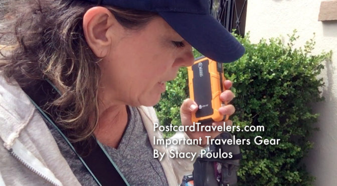
Important Travelers Gear by Stacy Poulos PostcardTravelers.com
Adventure friends here are some great must have important travelers gear! Sorry about the motorcycle / travel hair! LOL Anyway I guess my bag is not water proof. It’s water resistant. I found links from my affiliates….
Watch the video I give you a tour of my products I use when riding. Use at your own risk. Consult professionals.
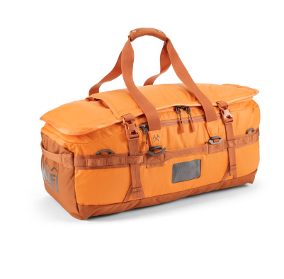
REI Duffel-backpack Water resistant heavy duty tie down loops.
❤️🎒 Duffel Bag turns Backpack from REI Co-op Big Haul 60 Duffel I love mine! The straps can easily be tucked away. It offers great water protection but apparently is not waterproof as I said in the video. It’s a soft plastic like material. I don’t like that harder water proof plastic material, this gives more. Most airlines require a piece of carry-on luggage to be no bigger than 45 linear inches (L + W + H) to meet carry-on size restrictions. This can vary check with your airline ahead of time. If you don’t fill it up, you squeeze down . . . . those extra 5.4 inches. There are a lot of heavy duty loops on the sides for tie down hooks and / or ropes. I don’t buy bags anymore that aren’t water resistant. I also think it helps keep the bugs out. How every this lovely orange attracts them lol. But I had to have it, thanks mom! XOXO http://bit.ly/2NE3XfI
iClever Jump Start thingie.
❤️🏍️🔌 iClever Jump Start thingie. This was a life saver!! I had to jump my bike 4 times in one day! The bartender came out of the bar with this. Thank you! I think all businesses / every one should have one to help people. It also charges cell phones, laptops and ipads! Anyway I found it on Amazon. It shows a motorcycle 12 V. [PD 30W Input & Output] iClever 20000mAh Car Jump Starter (up to 8L gas or 6.5L diesel engine), Power Delivery 30W Power Bank with Dual USB 3.0 Quick Charging for Nintendo Switch and MacBook… on Amazon. PS the hard part was attaching the clamps, as usual! Harley doesn’t give you room on the battery to grab the battery terminal. I just had someone hold it on it. (not exactly safe) MAKE SURE YOU CAN USE IT WITH YOUR BIKE! There is another way to jump start a battery on a motorcycle when I learn I’ll show you too.
❤️❤️🔌🔌 PocketJuice 2 and 3 out lets. This is a different Model. Mine is older. This one has a plug in thing, even better. I keep it with me all the time! It’s better to have one the size of you phone. I try never to leave with out it. https://amzn.to/2XI5NQB
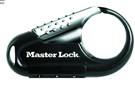
Carabiner Combination Lock
❤️🔒 Carabiner Combination Lock I made my own device with this adding the wire. It’s really to prevent people from cutting and running. I made the same thing when I went to Europe. I still have it, I just forgot the combination. 😎 https://amzn.to/2YrK2BD
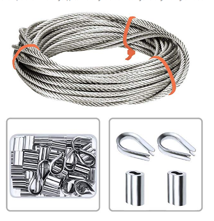
Make your own lock with wire rope and do-dad thingies.
🔒 Make your own lock with wire rope and do-dad thingies. Wire Rope Thimble / Loop-End Cable thingies. Here’s a kit. The size all need to be the same. And if you use the Master Lock Carabiner the thingie needs to fit the bottom loop. Technically you can make it any size and put it through the big loop. https://amzn.to/2KVOG88
❤️🔒 Blah, blah blah. If you don’t want to go through all that bullshit you can have a pre-made one that is coated. Heavy Duty Black Combination Lock Cable | Best Security PIN Locking Chain.
Pirates, shipwrecks, and Ghosts Adventure Map By Stacy Poulos PostcardTravelers.com
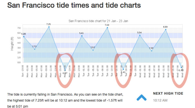
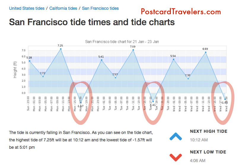
There is nothing like a full moon to uncover what lies beneath the surface of the earth. I’m not going to lie, I’ve been learning as I go about this phenomenon called ‘tides’ since I have been kayaking and was basically stuck in the mud trying to get to the shore walking my boat in mud up to my knees. It’s something I knew about but never really understood it’s wonder. And then there’s King tides. Which is an even greater water level. Which I took notice when I was kayaking in Alameda and couldn’t get close to my kayak partner because the current was so great and I was tired from a long day of kayaking. So it’s not advisable to be kayaking or boating, or even being near the edge of the water because of sneaker waves. But at low tied it’s a great time to see what has been under the water all this time. During this King tide the water level reached 7+ feet at highest tide in the SF Bay Area. For me this mean there are a few ships including one from the 1800’s I have to go see at it’s lowest tide. This King tide will last just a few days.
Unfortunately the lowest tide had been at sunset, and with the clouds almost impossible to see, but I DID! I was at Point San Pablo at 5pm ish and on the road looking into Point San Pablo Harbor and off to the left of the harbor you can see the shape of what appears to be a large wood ship. What is left is just the frame that look like a fence of just posts.
King Tides Week of January 21-23
Here are some important tips that will educate even just a hiker or walker along any Bay or shore in the world! No matter where you go. And if you are traveling, you are most likely planning on being near water! So be aware, knowledge is power.
Parking. With out looking at a tide chart, you can logically look at the ground and see where the water line is on low and high tide. Usually the water line is pretty apparent. Know that if it is low tide and your car is far away from the water. It can possible be submerged when you get back! Or the road you came in will be submerged as well. Almost for sure when there is a King tide.
Kayaking and boating and being stuck in the mud. Have no fear. Know that every 6 hours the Tide changes direction. Before it dose it will sit for a hour before it makes it way back called a slack tide. Most the time you don’t know the tide is even moving. So it can creep up on you. Lets say you planned to get out of the water and there is 20 feet of mud. You can wait it out cut it will eventually fill up.
Wikipedia Ebb and Flow
“Ebb and flow (also called ebb and flood and flood drain) are two phases of the tide or any similar movement of water. The ebb is the outgoing phase, when the tide drains away from the shore; and the flow is the incoming phase when water rises again. The terms are also common in figurative use…” – Wikipedia
“Slack water, also known as ‘the stand of the tide’, is a short period in a body of tidal water when the water is completely unstressed, and there is no movement either way in the tidal stream, and which occurs before the direction of the tidal stream reverses…” – Wikipedia
More incite: When you see a boat in the mud tipped over, have no fear. It’s most likely the owner misjudged the tides and soon the water will be back to fill up.
Boater rules. It is boaters curtsy and I think law that you’re never supposed to pass by a boater in need of help. [article] You could save their life, even if at the moment they seam to be fine.
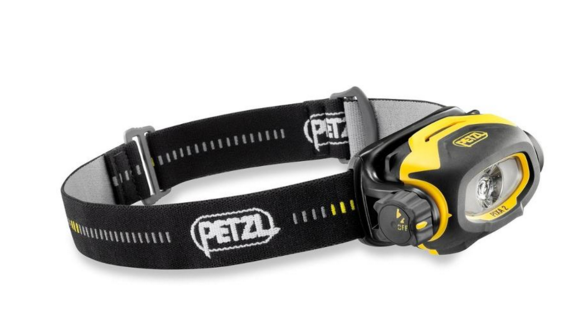
Currents. Currents are whats happening underneath. When you get near large objects like bridges, boulders, etc. The water rushes more and is stronger to get around those objects. Think of the SF Bay as a big bottle of water with a small neck (the golden Gate Bridge) that poor into another bottle of water and it takes 6 hours to pour on to the other bottle. As it pours back into the SF Bay it fills all the little bays as it goes back out to sea it’s sucks the water from the shore line leaving sometimes 4 to 20 feet of mud depending where you are at. This is world wide. If you don’t want to be stuck in the mud, plan on coming out of the water at high tide. However, you also want to think about the direction of the current. It’s a delicate balance of knowing the current. Sometimes, excuse my language but it can be a bitch going against the current! So there are 2 known factors tides and current. The wild card is weather / wind factor. You can go with a current but against the wind. And honestly I don’t know what is worse. And then there is light. Ya, you got it planned out on paper, but what about sunset? Will you be able to see when you get out? And if it’s cloudy or near mountains or cliffs you can loose hours of good light! Whew, thats a lot to think about. But you should always think about it!! One time when I was in Zion National Park we didn’t start a hike until 3pm, I know, duh!! Not my fault. Anyway, even though we could see at the top of the mountain. Walking back it was in the straight up dark! The mountains basically had us in a crack in the ground. Luckily I was prepared and had a head lamp light in my arsenal of stuff. Petzel is a great bran. Always buy your adventure gear at REI, I recommend becoming a member worth the bucks. You’ll get it back in lots of lifetime savings! They are our sponsor and affiliate because I love them!
Petzl Headlamps
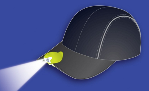
A cheaper and great option is this little head lamp that I clip on my hat. Best thing since sliced bread! I love it. I have two one for me and on for a adventure partner. They are usually never prepared. I always wear a baseball cap. If you don’t, it’s not the best option. For me, it is!
My Favorite Amphipod Swift-Clip Cap Light
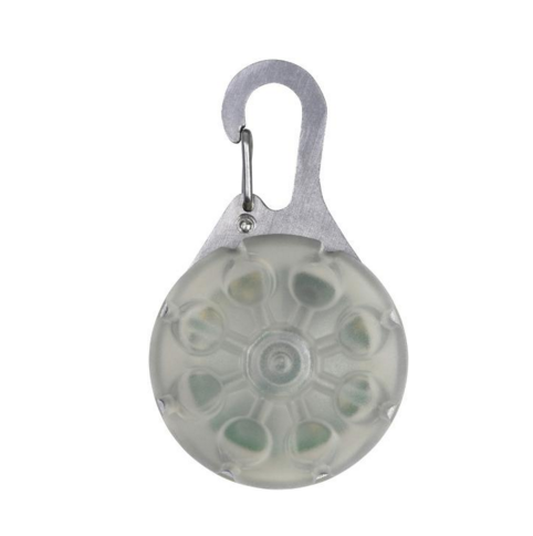
I also have one of these clipped on my belt hiking belt. And life jacket. I think it’s great to have at all times. Not exactly a flash ligt but in a emergency it can help guide you hime. However I don’t know how water proof it is. Just don’t be cheap about these items!
Favorite thins Nite Ize SpotLit LED Carabiner Light
Maps or better yet officially called “Charts” A NOAA chart will show you how deep the water is at it normal low level. It will also show ship wrecks the are submerged so boaters with engines don’t run into them. For me it’s a place to explore and how I found may locations of shipwrecks. They are free on line. If your a boater / kayaker I recommend buying the one of the area you frequent. For me it’s like a treasure map!
I will up date this blog as I find my shipwrecks during the King Tides.
May Adventure Map. Zoom into Ocean Beach Area, Hunters point and Richmond bridge area on the Richmond side and Point San Pablo. There are layers at the top you can turn on more layers and turn off layers.
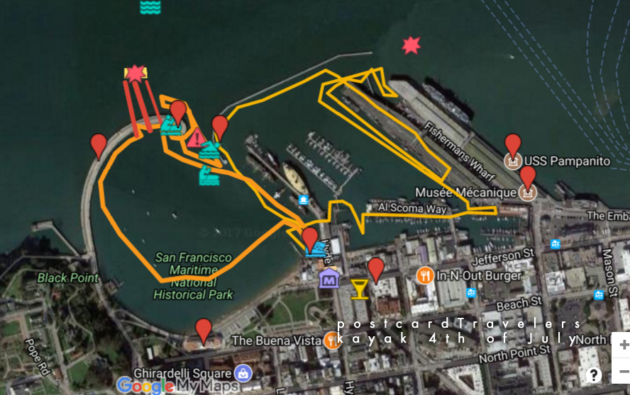
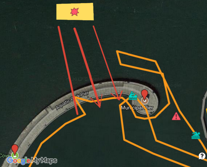
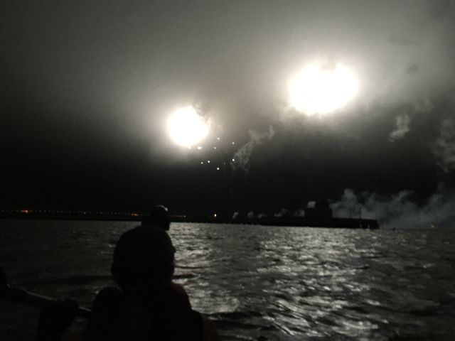
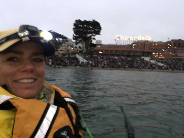
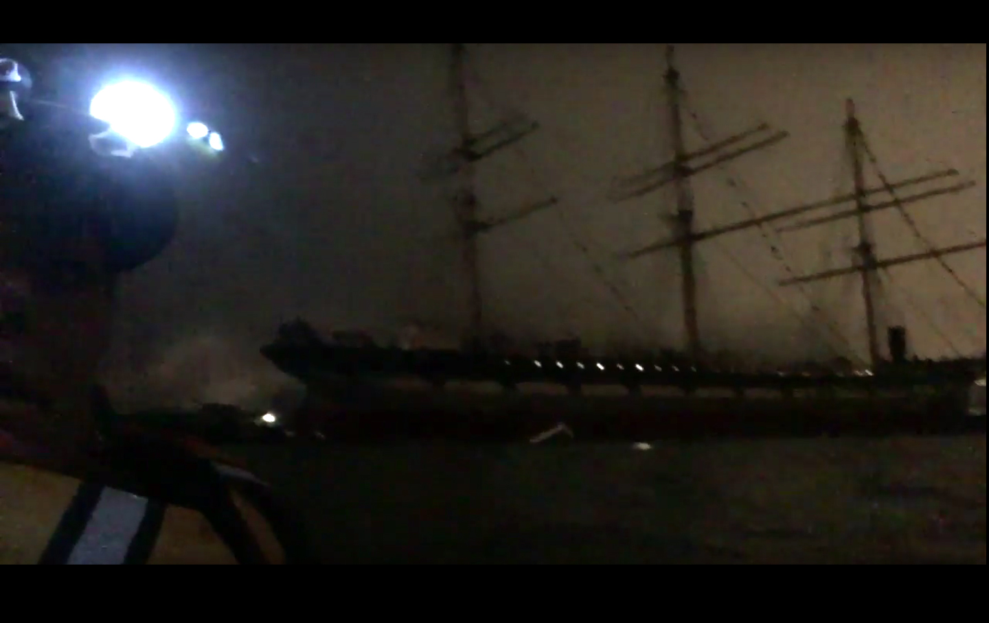
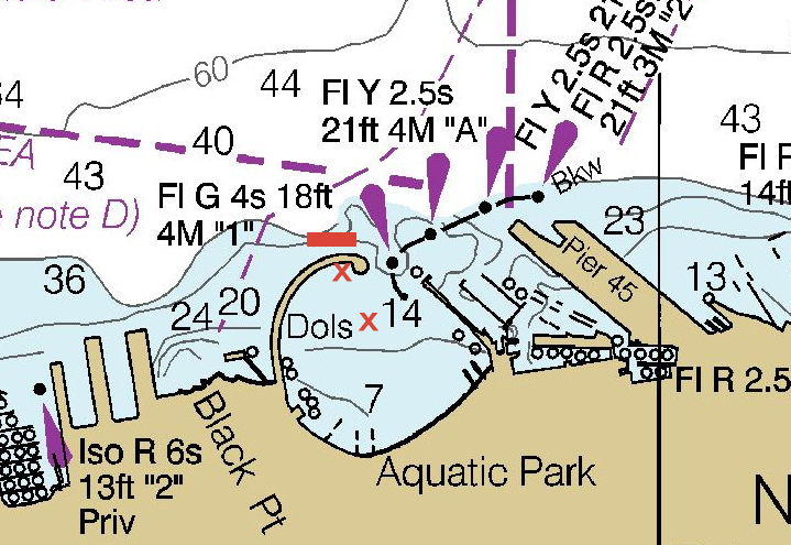
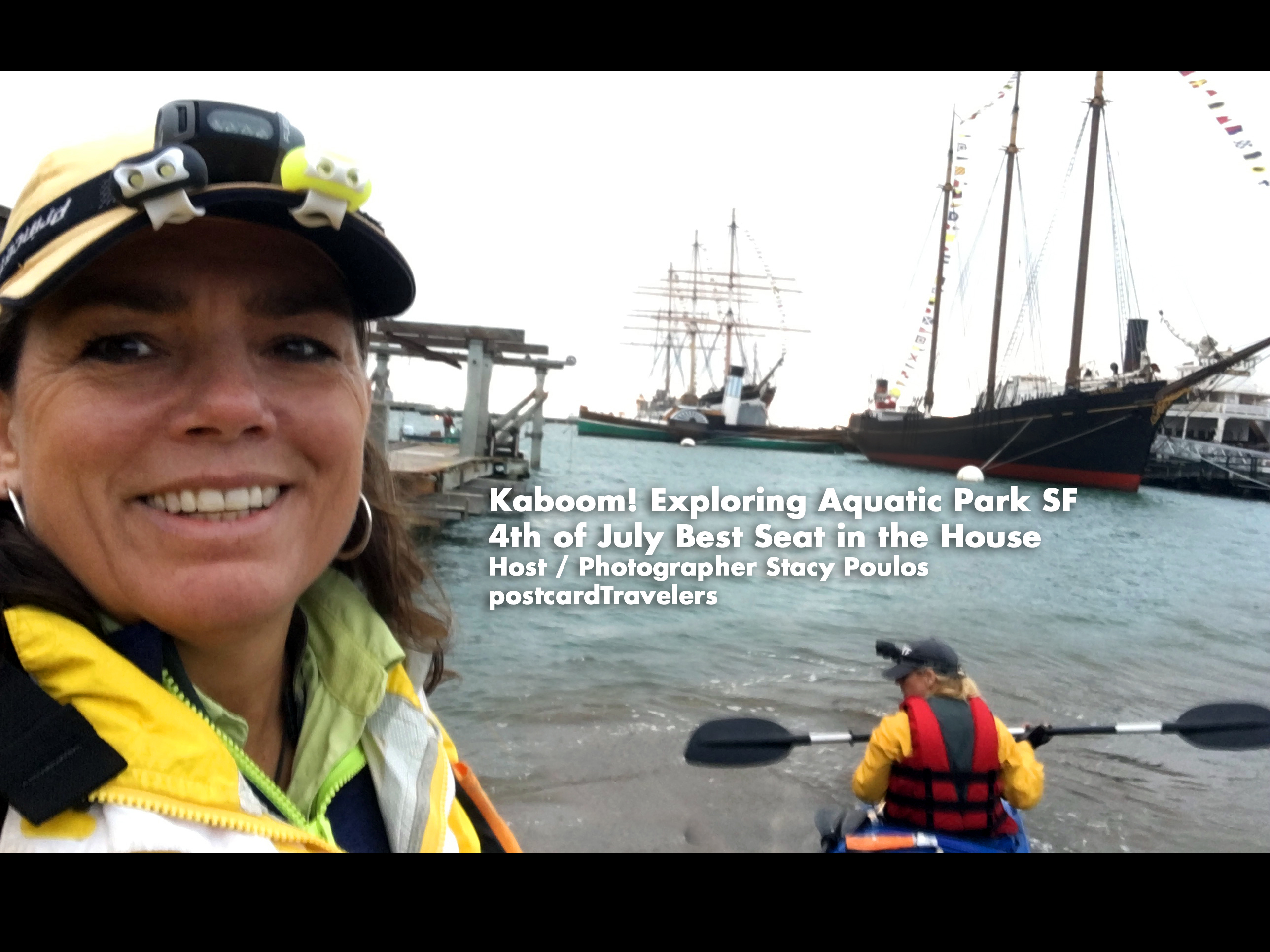
Kaboom! I can take this off my bucket list, being directly under the projection of the fireworks at the Aquatic Park Historic District pier! We put-in our boat and launched at Hyde Street Pier in San Francisco, California. Hovering under the pier A little too close for comfort, until the fireworks unsuspectedly started. The current kept making us drift quickly away so we hovered under the pier. We even had all our lights off to save batteries, so we were in the dark. The first echoing Kaboom explosionsunder the pier were un-describable. Enough to rattle your nerves! I was deeper under the pier being in the back of the boat looking out at Ghirardelli Square. *In this video I said ‘last time I got in trouble’. It was because I got too close to the Historic boats. There were no signs that I could see at the time. It is kind of roped off with buoys. This time we stayed further away out side the line. One way or another, I recommend this spot. During the day there is a live concert on shore. We had a back stage pass, a nice little additive to the day. The yellow box with the star is where the fireworks barge is. The Teal Green boater is where we hovered until the fireworks started.
fireworks projection san francisco Aquatic Park
However, I don’t recommend right there. Much too close. Instead bring a anchor at least 20 feet long and hover at a safe distance like we are in the photo below. To the left and center of the park here we are look at the Municipal Pier a posed to being under it!
Live Concert at Ghirardelli Square 4th of July
So, planning for next year. I recommend going here. Be more prepared. I do own a kayak anchor. When I looked at the Coast Guard Map it said it was around 7-14 feet deep in the area but there is only one marker and I didn’t think my anchor was that long. Besides it being a pain to add more weight. Next time I will bring one for sure! If your planning on hovering in the ocean, there is always a current. Anyway, below is a live interactive google map with all my notes for 4th of July over the years in the SF Bay. If you click on any icon, it will zoom into that note. When you click on ‘Aquatic Park Historic District‘ And look at the orange line that was our path in 2017. To the upper left of the map are my notes, that little box’ie icon on the upper top left corner opens the notes, click on anything at it will bring you to the spot on the map. Bottom right is the + and – zoom button. You can then close the notes with the left arrow it to get the notes out of the way. I also have a layer of land notes, where I intend to go for a city hike and check out the same area on land someday.
Aquatic Park Historic District pier Ghirardelli Square 4th of July
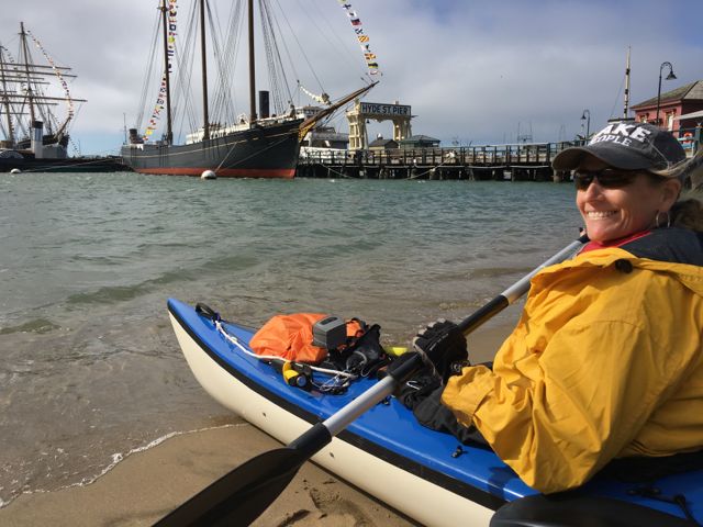
Launching on Hyde Street Pier AquaticPark. I’m not sure you can launch out of the museum. Since the public beach was full of people we couldn’t go their.
History of the 4th –
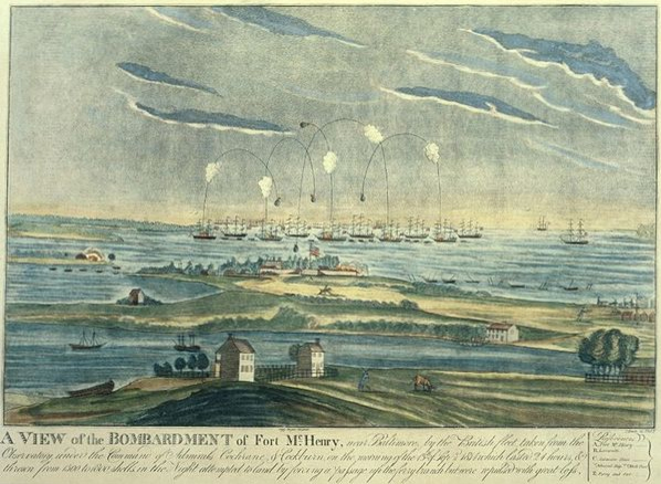
I think this is one of the safer and best spots in the San Francisco bay to view the fireworks from land or water. If you know the History of the 4th, or Independence Day and the inspiration to our National Anthem, you would know the 4th of July is meant to replicate what Francis Scott Key seen on that fateful day in 1812. He was a British lawyer on the French Ship; HMS Tonnant negotiating a British prisoner exchange were he was to negotiate the release of prisoners, during the Battle of Baltimore at Fort McHenry. (The only other place that can possibly top this spot). Key learned too much about the French’s attack on the British, so they kept him a prisoner as well. So all during that night Key witnessed the fireworks in the bay of Fort McHenry. In the morning when the fireworks stopped, and lack of communication the only way to know who won the battle was the American flag still standing. He wrote a poem “Defence of Fort M’Henry”, that later became the lyrics to ‘The Star Spangled Banner’.
So why is this the best spot? First of all, the Maritime National Historical Park is situated inside Aquatic Park San Francisco… in the water! There are period ships to set the perfect scenery of what the bay may have looked like. The ships are much younger in the park; like the Balclutha 1886 and the C. A. Thayer 1895 but look very similar. Add a dark sky with a silhouette of the old ships sails from the 1800’s lit up by fireworks, well you’ll get the picture and full effect. A lot of people don’t know this History, so why do I? I wrote a book report in the 4th or 5th grade about it. I found it fascinating that people were so affected and heart felt over a song, it inspired me to want to write music. So now you know. Now let’s let Key set the story and imagine the background.
Oh say, can you see, by the dawn’s early light, What so proudly we hailed at the twilight’s last gleaming, Whose broad stripes and bright stars, through the perilous fight, O’er the ramparts we watched, were so gallantly streaming? And the rockets’ red glare, the bombs bursting in air, Gave proof thru the night that our flag was still there. Oh say, does that star-spangled banner yet wave O’er the land of the free and the home of the brave?
SanFrancisco Maritime National Historical Park Fireworks Francis Scott Key, 1779–1843
So we won. And every year we celebrate this day in a grand way.
Reason 2, why it’s the best place to kayak on the 4th? The park is protected by a breakwater pier. However, that doesn’t mean there aren’t strong currents, but it’s a protected area and larger boats can only go 5 mph. There are actually crazy swimmers swimming at night. There are police and coastguards near by. Of course if you don’t have a walkie talkie that wont do you any good. So it is most watched by land and sea.
Next good reason, the fireworks barge is directly on the other side of the pier and they project the firework into the park. Giving the people on land and sea one hell of a show! Wow!! We hovered under the pier until the fireworks started because the current was so strong it kept making us struggle to stay in one spot. On land you can walk and board the ships.
The depth in the park looks to be 7 to 14 feet deep. Of course I wouldn’t recommend where I was, the first fireworks rattled me to the core. Being under the pier echoed the effect in such away that you felt you were in a war being bombed. Not sure your supposed to be under there but we needed to be protected by the current. Eventually we let loose and drifted to the center of the park facing the fireworks and current. It was foggy as SF is, but it also had a unique effect in it’s self.
Dolphin Swim & Boat Club and South End Rowing Club
We Put-in at Hyde Street Park. I’m not gonna lie, I’m not sure your supposed to. I heard there was a public beach launch to the left of the photo but it was all blocked for pedestrians to view the show on shore. Since we got out next door to the rowing and dolphin club, I assume they assumed we were with them. Frankly it’s not fair there aren’t more safe put in areas for the public to launch. So you might want to try to arrange something or find out the real rules. We parked our car in the red zone on Hyde street, dropped the boat off onto the side walk, my friend parked the truck while I waited. We communicated through walkie takies, which I highly recommend getting water proof ones even if you don’t think you need them. You don’t want to kill your phone batteries trying to communicate and it’s a pain other wise. I will list my personal favorite things kayaking. Eventually we walked the kayak through the crowded street.
So, the park is not that big to explore a whole day, and if your going out side the park it should be done in much better conditions. You can putt around the park and see the ships below, just don’t get too close or they get mad. To the right / east, are docks you can explore. You can go in a area all the crab fishermen dock their boats. There is a lot of untold History in them, some barely afloat. Also before you get in the water you can actually go on these Historic ships for a small fee that supports our wonderful parks.
It was next to the Dolphin Swim & Boat Club and South End Rowing Club. You might want get involved with them to launch your kayak. We technically just walked through the Hyde Street gate and put our boat in. However the gate closes at 5pm, so you have to be out by then, or the gate is locked. You can technically still get out from inside, but not go back in, should you leave something behind. It’s a beach launch and even though it’s a protected area, there is a strong current when it comes time. How ever it’s protected and the current isn’t as strong as out side the park. It’s cool because you kayak next to old ships. Perfect setting for 4th of July. We hovered under the pier until it came time for the fire works. But be aware, even at 9pm at night there are crazy swimmers. We had the best seat in the house, with a back stage pass to a concert and being literally under the projection of the fireworks! Here’s a important notation it’s a beach launch, pretty mild. You go through the gates of the Museum and the gates close at 5pm. Most the people who work at the Museum are volunteers over 90, kidding. I don’t think they care.
However you can still get out because the gate is only locked for people getting in. So if your out in the Bay and need a emergency out, here it is. There is a public restroom.
To take a rest, we ended up landing at the Dolphin Swim & Boat Club. The girl sitting on the beach was really nice and helped pull us ashore until she realized we weren’t members cuz we asked dumb questions. Then her face turned unfriendly like we were on her property and said they don’t take to kindly to non-members. So we went next door, and went out the Row Club doors to the street. Much more friendly group of people. They promised they would let us back in to get to our boat.
We just wanted out of the water to rest. We just weren’t sure where to go, so we can come back to our boat. I just think it’s pure BS. 4th of July, land of the ‘free’ BS. Land of we own this, get the f’ off. When it comes to boating it’s dangerous to send boaters back out that need to rest. Or set their lights or get out of rough waters. We had struggled for a long time against the currents and wind, we needed to rest. I’ve got nothin’ for people that don’t help, sorry I disturbed your cozy picnic. I mean we are loaded down to kayak, do we look like we want to stay here? All in, all. There were only 4 kayakers besides us, anyone who really kayaks wouldn’t go out in, apparently, gusting winds which I wish they would say MPH, which is 16.1 to 19.6 MPH. Gusting means ‘gusting’ temporary burst of wind. Ok got it! Ya, so I’m learning as I go. Anyway, take that off my bucket list.
Old Fishing Boat Fisherman’s Warf SF Stacy Poulos Photography
Anyway, once parked we went across the street to the fancy Blue Mermaid Restaurant. I looked like a Uni-bomber with my kayak vest still on, walkie talkie, pilot knife. I had coffee while my friend had oysters and beer. Absolutely beautiful restaurant. I must go back. Anyway, all in all it was such a great evening. After the hair raising fireworks, Instead of leaving immediately, we loaded up the car with the boat, parked then went to a bar Jacks Cannery Bar for a night cap to let all the traffic go away. Sucks having to drink expensive beer (cash only) out of a plastic cup, when you just risked your life, I don’t know how many times… welcome back to land. But there was a mixed group of out of town’ers fun to chat with.
Below I listed some of my favorite things kayaking.
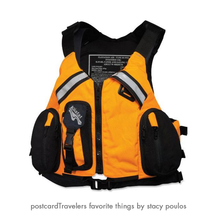
#1 My Kokatat MsFIT Tour PFD – Women’s Life vest.
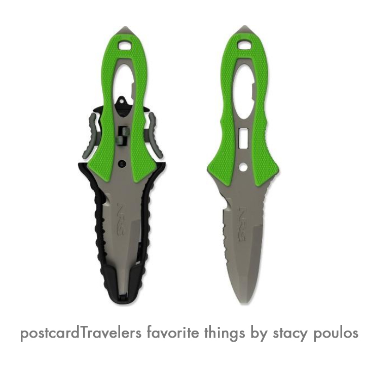
I love the walkie talkie pocket and the front stretch mesh pockets to stow essentials. The pocket are not water proof. But when I do put things in the pockets, they are in plastic in need be. The deep-cut neck and armholes maximize range of motion for my arms, there is a difference! I used to kayak with a ‘water ski jacket’ and it gave me rub burns under my arms. Your life vest is –your LIFE Vest! It’s a investment. Having things on your body and not hanging from your neck it super important. If you capsize you have less to get hung up on. Chapsitck and sunscreen and cell phone is in the pocket! However, getting back in the boat you have the pockets to contend with. Kokatat is a great brand, when I went to The Travel Show, a pro Kayker had one and she gave me a personal tour of her’s and she swore by it. I had my eye on it the first day I seen one. They are all very adjustable in size. I have a Large. You can say I’m smitten by mine. It also has a ‘Strobe lash tab’ I guess thats what they call it. Anyway, you can attach other things to it, for me I have my Rambo ‘NRS Pilot Knife’ which I love. There is Reflective tape on the back and chest. You never know when you will be out at night fall.
I will get more into products I love in a dedicated blog
Kokatat MsFIT Tour PFD Women pro favorite My NRS Pilot River Knife (Rambo) knife is always ready for action. It’s 3 inch stainless-steel blade with blunt safety tip has both smooth and serrated cutting edges; matte finish with a are hole in the handle that serves as a valve wrench for an oxygen tank a bottle opener is built into the handle. Comes in handy for many uses.
My NRS Pilot River Knife (Rambo) knife is always ready for action. It’s 3 inch stainless-steel blade with blunt safety tip has both smooth and serrated cutting edges; matte finish with a are hole in the handle that serves as a valve wrench for an oxygen tank a bottle opener is built into the handle. Comes in handy for many uses.
Motorola MS350R 35-Mile Talkabout Waterproof 2-Way Radio (Pair)
This is one of my favorite products. You think, everyone has a cell phone why not just call? You don’t want to ware out your cell phone communicating out on the road, trail or water. I use them everywhere! Hiking, kayaking. Used them in Europe to talk to my friends. Hands down best buy. They have a charging case so you just place them in the cradle after a long day. My mom got me mine for my birthday. You don’t want to dial and wait to ring, you want to send your message.
Ad a whistle to your vests, (super important) and your good to go! The whistle replaces a horn on a boat. I’ve actually been hit by a big boat, not dead on but swiped the side of my kayak. Having a whistle can help you let them know you are their since we sit so low in the water.
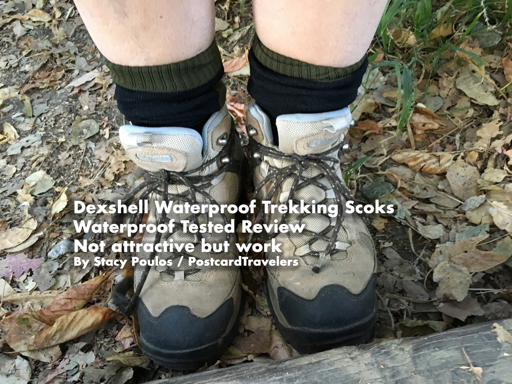
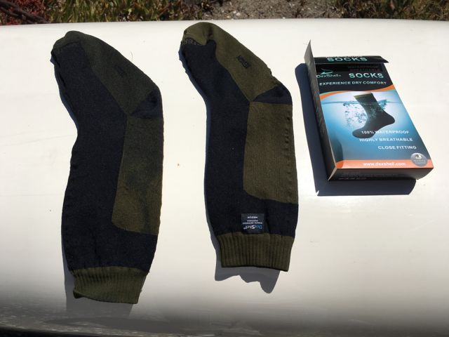
Dexshell Waterproof hiking and kayaking Socks http://amzn.to/2vd8ppaWaterproof Tested Review, Not attractive but works By Stacy Poulos PostcardTravelers –Unless of course you think my legs are sexy?
I recommend Dexshell Waterproof Socks! If Dexshell says it’s waterproof, I believe it! Not attractive but good! This link has more and better options. http://amzn.to/2vFv3JI XOXO
Ok, as you may know I have different interest in sports and like to get equipment with duel purpose. When you do any sport, it sucks to get wet and be in the cold. Your feet, hands and chest are the most important for me to stay dry and warm. So I got neoprene socks for kayaking, they may keep my feet warmer, but they don’t keep them dry! I keep seeing these ‘waterproof socks’ and thought I’d try them out. I figured I can also use them for hiking on rainy days. So I set out to dip them in water to see if they were in fact water proof and wa-la, they were. TIP: My feet stayed dry. My second suspicion was my feet will sweat more being in a something that keeps out water. However, this will also lock moister in when you sweat. So I put a cotton sock under one sock and one with out on the other. Yes, the one without a cotton sock, underneath was little more sweaty after a mild, 2 mile hike which means maybe after a long day, a lot more sweaty. So I say layer with a cotton socks. The socks are already thick and to me very unattractive. I got the Black and Olive socks. However, who cares when your feet are cozy warm and dry? Anyway, you can see for yourself in this video I made. Enjoy. Here is a link to them on Amazon. I got a medium. I don’t mind that they are longer, I intend to tuck them under my dry pants when I kayak.
Price? There are different prices, not too spendy for the importance of dry feet. I would have a pair in all aspects of my life. I’m going to leave mine in the car with my hiking boots.
Dexshell Waterproof hiking and kayaking Socks http://amzn.to/2vd8pp – Waterproof Tested Review Not attractive But works By Stacy Poulos PostcardTravelers I Recommend Dexshell Waterproof Socks
Dexshell Waterproof hiking and kayaking Socks http://amzn.to/2vd8pp – Waterproof Tested Review Not attractive But works By Stacy Poulos PostcardTravelers I Recommend Dexshell Waterproof Socks
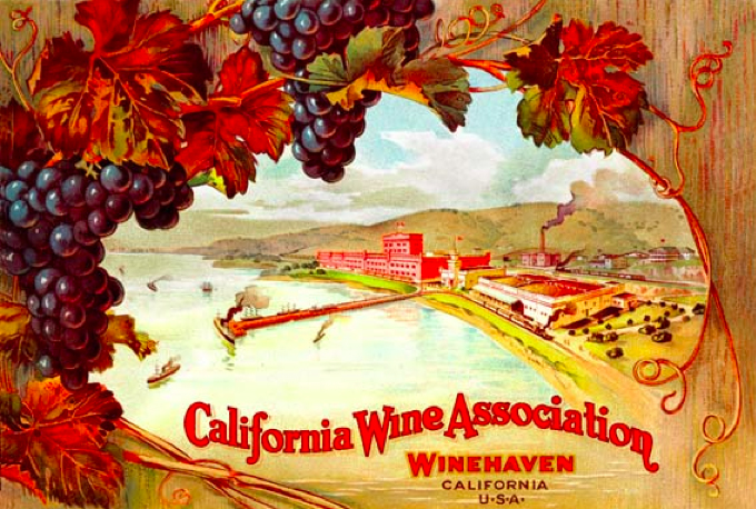
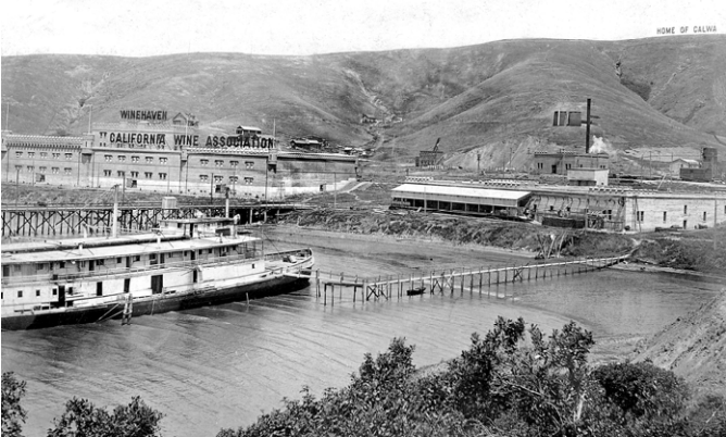
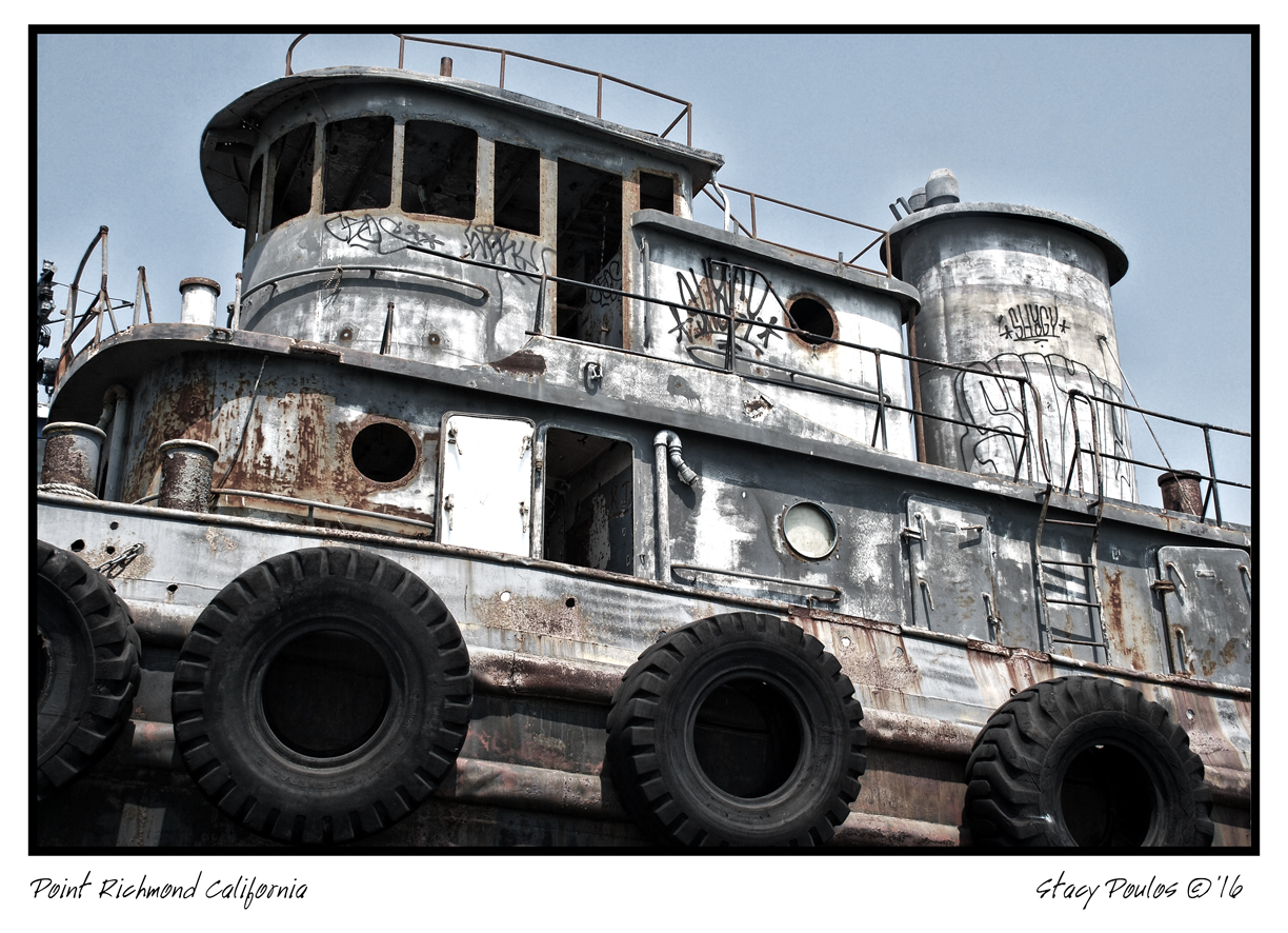
I’m always astonished how much rich History, or HerStory, there is right under our noses in the San Francisco Bay Area. I explored the waterfront area of Richmond by land and sea in search of what was once the largest Winery in the world when the California Wine Association moved from San Francisco to Point Molate Richmond after the San Francisco Earthquake in 1906. It remained the title of “World’s largest winery” for 12 years!! (1907–1919). Until prohibition crushed it’s demise and was shut down in 1919. Really, THE largest? Over Italy and France? Yep, it’s true. Now it’s an abandoned ghost town once called “Winehaven California” (It is in the U.S. National Register of Historic Places) and it’s castle remains in tact north of the Point Molate Richmond. Stenmark Drive is the last exit before you get on the Richmond Bridge and it is littered with a extraordinary and riveting California History.
The largest Wine producer in the world for 12 years.
If you walk on Pt. Molate Park Beach facing the water Winehaven would be to your right, around the corner less than a mile away, you can’t walk to it on the beach, but you can see it. If continue to drive on Stenmark Dr you can see the backside through the fence from the road. There is a bit of a battle to what they are going to do with the area. In my humble opinion, it is rare to be able to boast the ‘largest in the world’ of anything, let alone the most prestigious commodity of wine! So. I say restore the castle and keep boasting! But there’s more.
Winehaven 2036-2040 Stenmark Dr. Near Point Molate Beach Park Richmond, CA
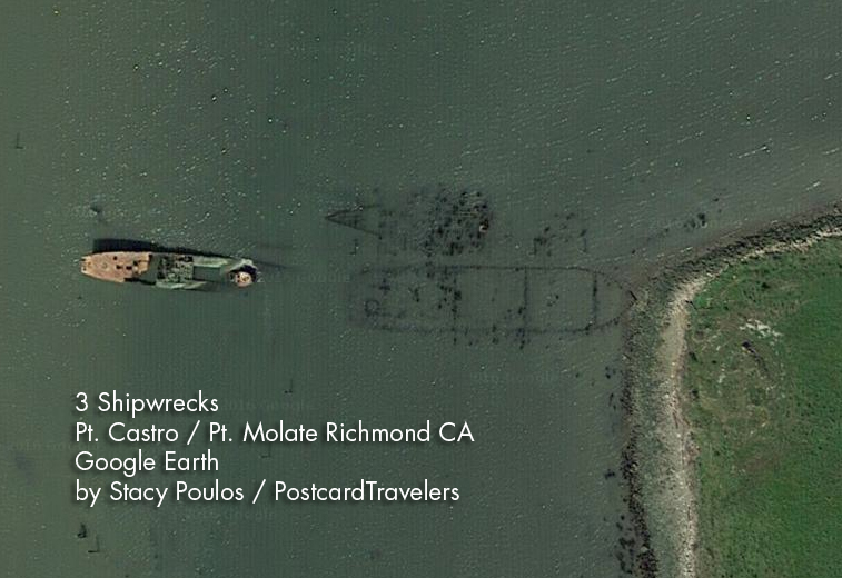
From that same beach, to your left walk 1,000 feet towards the Bridge to Point Castro and there is a 200 foot shipwreck, with half sticking out of the water even at high tide. (There are actually 3, if you look at Google Earth. 5 If you look at lowest tide.) With the completion of the bridge in 1956 the car-ferry service and inner city railway that resided there eventually rendered the pier useless and became a fishing pier. After years of lack of maintenance, it is now a barley recognizable battered pier. This once thriving corner of the Bay, is now a water front ghost town, mostly restricted from the public. For me, it’s a photographers dream. There is a public park you can enjoy where you can see the shipwreck. A 160-foot medium-endurance cutter patrol vessel ‘The USCGC Hermes WPC-109’ it was a Thetis-class coastal patrol ship in service from 1932 to 1958. It was assigned to San Pedro, California, and spent World War II watching for Japanese submarines, as well as escorting convoys out of the harbor. After the war, it was used as a stationary training ship. And was to serve as an enforcement vessel for Prohibition. A model is on display at the LA Maritime Museum. Hermes also served to deliver an important marble Cabrillo monument January 1937 to the San Miguel Island in the Southern California. In honor of Juan Rodríguez Cabrillo (Portuguese: João Rodrigues Cabrilho; c. 1497 – January 3, 1543) who was the First European explorer in California where he laid to rest. And yet another part of our Rich History.
The Hermes vessel was decommissioned November 2, 1948 and sold May 16, 1958. Eventually laid to rest where it is now, Point Molate. She still sits with her bow in the air above water, surrounded by unnamed shipwrecks beside her, slightly below the water line. You can see them on google earth, and on a lowest tide you can see them even more. It is a dangerous area with pilings sticking up.
Just know it is windy out there facing the Golden Gate. If it’s a date night you can start here and work your way back to end up at the wineries near, The Riveter Rosie Museum. To me it’s crazy this area is not as explored as it should be. And I pray they do not develop this but to bring back what was there.
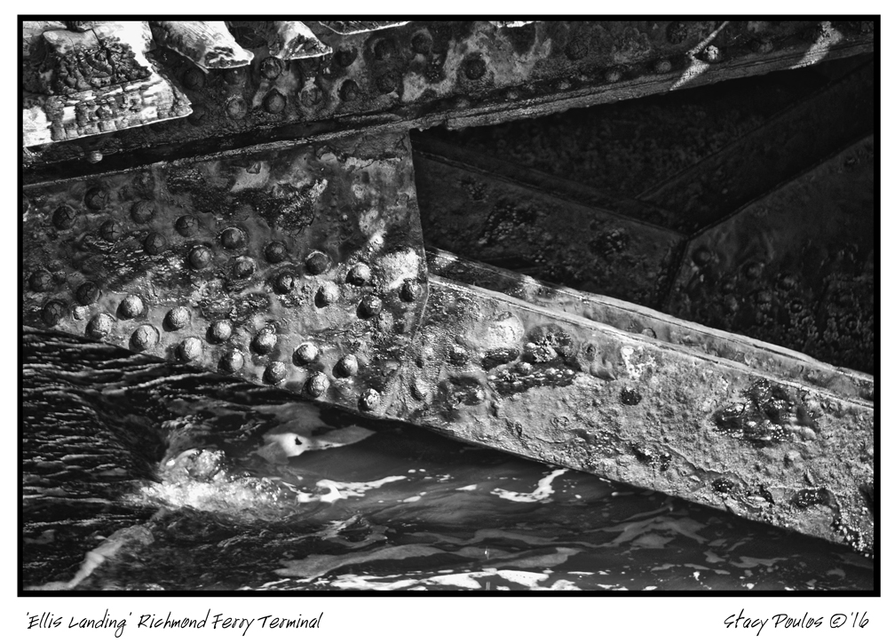
Point Richmond Ferry Terminal (aka Ellis Landing)
Point Richmond Pier
Next stop is Miller / Knox Regional Shoreline at Point Richmond on Canal Blvd. At the very point, is a gutted out building. And a fishing pier which. Along side the new fishing pier is a dilapidated pier that used to be a commuter ferry service to the San Francisco Ferry. You can see where the train rails lead to the terminal which now are broken and lead underwater. I actually kayaked under it. Besides being broken-down and battered, it is clear there was a recent fire that further damages the battered pier. For me, it was the highlight of my 2nd kayak trip. It is said, it is at ‘Ford Point’ however you can’t find it on the map. Something I have found over time, places are renamed and it really depends on who you ask. It’s name came from the historic Ford Plant. But you put in ‘Point Richmond’ and you will find it. There is a whole walking tour of the area with points of interests. Across from the Museum is R&B Cellars where you can wine and cider taste and have a bit to eat while you enjoy the Bay view.
Now it’s time to warm up and get out of the wind. Working your way back go to see the inside of the SS Red Oak Victory ($10 donation to get in, mostly Closes at 2pm). I have not been inside yet, however I have been under the massive destroyer it in a kayak. It’s A original ship made by the Rosie The Riveters. If you aren’t familiar who Rosie is, during WWII all the available men were summoned to fight the war with no one left to build the Ships and Airplane’s. So women were summoned to come work in the shipyards. There is a famous print by Norman Rockwell that advertised “You can do it” to encourage women to join the movement where the women, who other wise were expected to be housewives were summoned to work in the shipyards. Back in those days it was ludicrous a woman would do a “man’s job”—even if they wanted to. Rivets are basically like ‘a nut and bolt’ a all in one, permanent mechanical fastener that holds metals sheets together to make airplanes, ships, bridges and such. They did more than assembled them with rivets, they welded and did all types of non-traditional jobs. It was war-time and Richmond area was the largest producer of war time products. The rural City of Richmond exploded. Now the whole area is dedicated to preserving this HerStory.
Shipyard Trail General Warehouse Richmond 2016 By Stacy Poulos
1414 Harbour Way S #3000, Richmond, CA 94804 (510) 232-5050
After seeing the ship, go to the Rosie The Riveter Museum, it’s very tactile with life size people to give you a sense of that time. Maybe even go home with a lunch pail. Especially if you have kids, they should see how woman contributed to the war effort. The Museum is free but if you can spare it, donations are always appreciated.
Now that you’ve had a day of HerStory, reward yourself at the Assemble Restaurant you basically get to eat and drink in the boiler room of the Ford Assemble plant.
Assemble Restaurant @ The Craneway Pavilion, 1414 Harbour Way S, Richmond, CA 94804
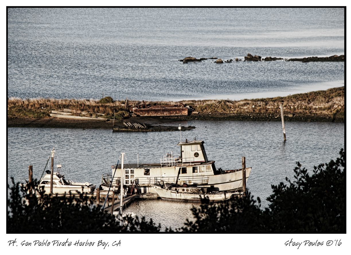
Now you have a choice to call it a day and watch the sunset there, or go back to see the sunset over a Pirate Harbor. Yep, a pirate harbor only you me, John Wayne and and a few others know about. If you continue on back on Stenmark Dr. past Pt. Molate Park Beach make a right onto a dirt road to San Pablo Yacht Harbor or they like to say San Pablo Pirate Harbor. They have developed the area in such a what that its very artiest friendly environment.
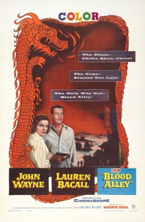
Follow the ‘Point San Pablo (Pirate) Yacht Harbor sign. There are is a public bathroom and public kayak launch. But this little eccentric cove has a long History. Is was originally made by By Captain Raymond H. Clark in 1939 lined up about 9 ships on both sides to create a breakwater Harbor eventually overtime the ships were covered with dirt. And yes, that’s what you walk on.. shipwrecks. Fascinating. At sunset, at least on this day was a golden calm. At one point in History that area was the setting of the movie ‘Blood Alley’ with John Wayne and Lauren Bacall!
Update! There is a quaint restaurant you’ll have to figure out what they have there now. Here is a link: https://www.pspharbor.com/ I promise you explore this area by kayak, car or foot, you will not be disappointed!
Point San Pablo Yacht (Pirate) Harbor
Many buried ship wrecks
1900 Western Drive, Richmond, CA 94801
+1 510-233-3224
1955 ‘Blood Alley’ with John Wayne and Lauren Bacall partly filmed at Point San Pablo Harbor.
I’m kayaking 4th of July and thought I’d share a few links. Last year I was in front of Pier 39 See video clip. I recommend Aquatic Park San Francisco for kayak’ers.
4th of July Bay Area Water front Fireworks Double check the links for current information on google map.
More fireworks double check links – I found the headings aren’t all accurate when you click on the link. Always check the city when you find a spot. I will keep my Google Map updated.
I love a great discoveries! Today I toured the ‘Jack London Square bay’ taking photos on a Kayak with a friend. We went in the public entrance at Jack London Square, free to launch my own kayak, and my friend rented a paddle board $15.00 an hour at “California Canoe And Kayak” which was very helpful and lots of cool stuff to buy. We parked our car for $5.00 for 12 hours a block away takes cash and cards.
After, my friend wanted to go a restaurant ‘with a view of the water’ and we were too dressed down from paddling to go in any of the fancy restaurants, so we poked around and found ‘Miss Pearl’s Jam House’ Cuisine Inspired by the Caribbean Islands. It looked fancy, but we asked if it was ok the way we were dressed, and they welcomed us with open arms. When I saw ‘gumbo’ on the menu I knew that’s what I wanted. I am always excited and leery about restaurants that claim to make ‘Gumbo’ I’ve had the best ‘Gumbo’ in the center of New Orleans. And I haven’t come close to what I’ve experience yet and that’s always a disappointment when your pallets been so sophisticated. So I took a chance. I ordered the “Creole Gumbo” (Pulled chicken, Andouille sausage, Tasso ham, Gulf Prawns, and Okra, floating around a cup steamed rice) ($18.00). I’m not a huge fan of Okra, so I asked them to use a little less, and dice it. They were happy to accommodate me and my ‘high maintenance’. It was soooo good, I am trying to figure out when I can come back again. I forgot to ask for extra sauce, as I do for everything I ever order, but it came plenty saucy already- woo hoo extra bonus! The meats were of high quality had a great texture and flavor.
My friend had just a few appetizers, very tasty ‘Rosemary Polenta’ ($4.00) and ‘Seasonal vegetables’ ($4.00) which happen to be ‘Young Broccoli marinated in fresh (un-refrigerated, huge difference!) potent Garlic cooked absolutely perfect.
So as the sun fell on the water, we enjoyed a superb 2008 Petite Sirah; R&B Cellars Pizzicato, Napa Valley’s; Rock Wall Wine Company ($9.00 glass). www.rbcellars.com From a very fun and knowledgeable waiter and staff that checked in often. They went as far as letting me in the kitchen to get a photo. If you didn’t get the window view, the restaurant is uniquely designed with beautiful mosaic sea shell tiles on the wall. If you go into the bar, they have live music as well, and a nice atmosphere. I’m definitely coming back soon. Problem is, there looks like a lot of good stuff on the menu, but I think I’ll have the gumbo again, and warm up to the chef for the recipe.
Caio’ for now. -Stacy
Miss Pearl’s Jam House
Cuisine Inspired by the Caribbean Islands
One Broadway, Oakland, CA 94607
Jack London Square
at the Water Front Hotel
Telephone: 510.444.7171 http://www.misspearlsjamhouse.com