After 2 years of planning and a 2nd attempt to find it on the Delta, I finally found my Shipwreck! For now it’s the ‘Spud Island Shipwreck’ since there are no markings and I can’t find any information on it. It will officially be the ‘Spud Island Shipwreck’. On the way to the wreck #CaptainBonnie (Bonnie Nasworthy Jones) pointed out a sunken city. I call ‘Jones Track Ghost Town’, an abandoned sunken Ghost Town. It consists of a few floating (or not floating) buildings and house boats abandoned by a man who left them behind to live in Costa Rica. Now the Delta is slowly swallowing them up. It’s definitely a ominous Ghostly scene. I took many photos of both locations. I didn’t get to spend as much time flying over them for my battery only lasted 10 minutes. rrr. Anyway, what a journey! Thank you Captin Bonnie for being such a brave, patient and great caption to get me there and back safely through the twisted and dangerous areas of the Delta and San Joaquin River! Stand by for the video ‘Journey to Spud Island Shipwreck’ and keep and eye out for my photography from the trip. www.PostcardTravelers.com by Stacy Poulos & Eye Fly Cinematography
Hike/ Palos Colorados Trail Head – Joaquin Miller Park 40 Joaquin Miller Ct, Oakland, CA 94611
This is a great, completely shaded, hike in the Oakland hills of California. ‘Palos Colorados Trail’ is just one of the many ‘Joaquin Miller Park’ Trails. Palos Colorados you can hike round trip about 3 miles along the Palo Seco Creek, well the creek is at the bottom of the hill. (On my map below it’s the red line). With a 688 feet elevation gain. (Down hill on the way back). (Get the official Oakland Trails Map https://oaklandtrails.org/maps/)No bikes allowed. If you choose to go on a bike trail for part of it, continue on the the orange line (The Sinawik trail) going back on that one will also make you end up, up-hill. Or just double back on the Palos Colorados like we did. I wasn’t looking to break a record, just get the body moving. I mention I was on a Keto Diet, I didn’t follow it in it’s entirely, I mostly changed many things in my diet and cut out the CARBS and sugar and lost 30 pounds. The coconut Oil I speak of was MTC Oil, here’s a link. You have to have ‘good fat’ in your diet. Avocado everyday and MTC Oil (Coconut Oil). I Have it everyday in my coffee. I also get it from Vitacost about $14.00 where it retails $23.00 as well as many of my Vitamin products. (Free shipping when you reach a certain amount). I feel great! 30 days before my next birthday I was determined to change my life in every way. You really see results fast with Keto with just a few changes. I also changed my beer, (your really not supposed to drink beer but I know having one 2/3rd less carbs also played a big factor). I did many other things that contribute to anti aging like nuts, berries, etc. At some point I’ll get more into it. Like I found on a rock; “What you are not changing, you are choosing”. I don’t want to be like the rock!
Keto Diet-MTC-Oil
Any way, I mention a very ‘old metal pipe’ in the video turns out, they are remnants from an old water delivery system that fed the neighborhoods below Joaquin Miller Park from a reservoir that once occupied the meadow inside the park. So, no, it’s not for Gold mining as I thought, that I know of. If you look closely though you can tell it was made a long-long time ago.
The hike has some good elevations for interesting views and exercise. It’s a narrow trail, with a big drop. The one we went on has no bikes, but you can make sort of a round trip and end up behind Monaghans Oakland if you chose to take the bike trail back. But you are always dealing with bicyclist. And to get back to your car, you will have to walk on the road. Unless you leave a car at Monaghans, then you can drive your friend back after you have lunch. Be cautious where you park, they tow cars around Monaghans! Anyway Have a great day, enjoy the trip.
Pirates, shipwrecks, and Ghosts Adventure Map By Stacy Poulos PostcardTravelers.com
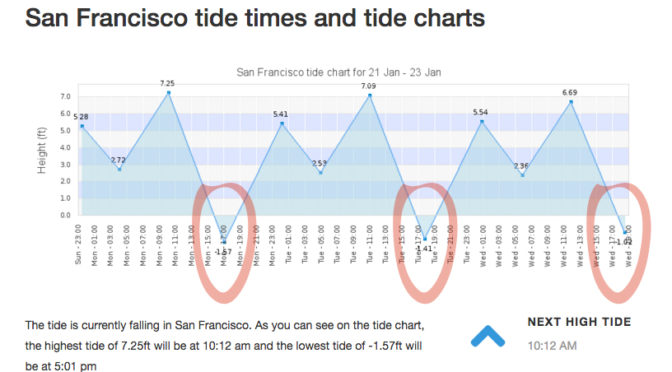
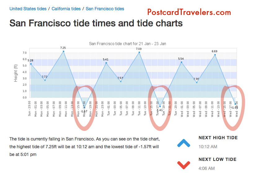
There is nothing like a full moon to uncover what lies beneath the surface of the earth. I’m not going to lie, I’ve been learning as I go about this phenomenon called ‘tides’ since I have been kayaking and was basically stuck in the mud trying to get to the shore walking my boat in mud up to my knees. It’s something I knew about but never really understood it’s wonder. And then there’s King tides. Which is an even greater water level. Which I took notice when I was kayaking in Alameda and couldn’t get close to my kayak partner because the current was so great and I was tired from a long day of kayaking. So it’s not advisable to be kayaking or boating, or even being near the edge of the water because of sneaker waves. But at low tied it’s a great time to see what has been under the water all this time. During this King tide the water level reached 7+ feet at highest tide in the SF Bay Area. For me this mean there are a few ships including one from the 1800’s I have to go see at it’s lowest tide. This King tide will last just a few days.
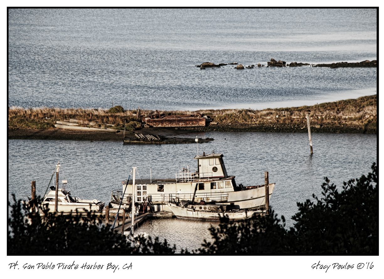
Unfortunately the lowest tide had been at sunset, and with the clouds almost impossible to see, but I DID! I was at Point San Pablo at 5pm ish and on the road looking into Point San Pablo Harbor and off to the left of the harbor you can see the shape of what appears to be a large wood ship. What is left is just the frame that look like a fence of just posts.
King Tides Week of January 21-23
Here are some important tips that will educate even just a hiker or walker along any Bay or shore in the world! No matter where you go. And if you are traveling, you are most likely planning on being near water! So be aware, knowledge is power.
Parking. With out looking at a tide chart, you can logically look at the ground and see where the water line is on low and high tide. Usually the water line is pretty apparent. Know that if it is low tide and your car is far away from the water. It can possible be submerged when you get back! Or the road you came in will be submerged as well. Almost for sure when there is a King tide.
Kayaking and boating and being stuck in the mud. Have no fear. Know that every 6 hours the Tide changes direction. Before it dose it will sit for a hour before it makes it way back called a slack tide. Most the time you don’t know the tide is even moving. So it can creep up on you. Lets say you planned to get out of the water and there is 20 feet of mud. You can wait it out cut it will eventually fill up.
Wikipedia Ebb and Flow
“Ebb and flow (also called ebb and flood and flood drain) are two phases of the tide or any similar movement of water. The ebb is the outgoing phase, when the tide drains away from the shore; and the flow is the incoming phase when water rises again. The terms are also common in figurative use…” – Wikipedia
“Slack water, also known as ‘the stand of the tide’, is a short period in a body of tidal water when the water is completely unstressed, and there is no movement either way in the tidal stream, and which occurs before the direction of the tidal stream reverses…” – Wikipedia
More incite: When you see a boat in the mud tipped over, have no fear. It’s most likely the owner misjudged the tides and soon the water will be back to fill up.
Boater rules. It is boaters curtsy and I think law that you’re never supposed to pass by a boater in need of help. [article] You could save their life, even if at the moment they seam to be fine.
Currents. Currents are whats happening underneath. When you get near large objects like bridges, boulders, etc. The water rushes more and is stronger to get around those objects. Think of the SF Bay as a big bottle of water with a small neck (the golden Gate Bridge) that poor into another bottle of water and it takes 6 hours to pour on to the other bottle. As it pours back into the SF Bay it fills all the little bays as it goes back out to sea it’s sucks the water from the shore line leaving sometimes 4 to 20 feet of mud depending where you are at. This is world wide. If you don’t want to be stuck in the mud, plan on coming out of the water at high tide. However, you also want to think about the direction of the current. It’s a delicate balance of knowing the current. Sometimes, excuse my language but it can be a bitch going against the current! So there are 2 known factors tides and current. The wild card is weather / wind factor. You can go with a current but against the wind. And honestly I don’t know what is worse. And then there is light. Ya, you got it planned out on paper, but what about sunset? Will you be able to see when you get out? And if it’s cloudy or near mountains or cliffs you can loose hours of good light! Whew, thats a lot to think about. But you should always think about it!! One time when I was in Zion National Park we didn’t start a hike until 3pm, I know, duh!! Not my fault. Anyway, even though we could see at the top of the mountain. Walking back it was in the straight up dark! The mountains basically had us in a crack in the ground. Luckily I was prepared and had a head lamp light in my arsenal of stuff. Petzel is a great bran. Always buy your adventure gear at REI, I recommend becoming a member worth the bucks. You’ll get it back in lots of lifetime savings! They are our sponsor and affiliate because I love them!
Petzl Headlamps
A cheaper and great option is this little head lamp that I clip on my hat. Best thing since sliced bread! I love it. I have two one for me and on for a adventure partner. They are usually never prepared. I always wear a baseball cap. If you don’t, it’s not the best option. For me, it is!
My Favorite Amphipod Swift-Clip Cap Light
I also have one of these clipped on my belt hiking belt. And life jacket. I think it’s great to have at all times. Not exactly a flash ligt but in a emergency it can help guide you hime. However I don’t know how water proof it is. Just don’t be cheap about these items!
Favorite thins Nite Ize SpotLit LED Carabiner Light
Maps or better yet officially called “Charts” A NOAA chart will show you how deep the water is at it normal low level. It will also show ship wrecks the are submerged so boaters with engines don’t run into them. For me it’s a place to explore and how I found may locations of shipwrecks. They are free on line. If your a boater / kayaker I recommend buying the one of the area you frequent. For me it’s like a treasure map!
I will up date this blog as I find my shipwrecks during the King Tides.
May Adventure Map. Zoom into Ocean Beach Area, Hunters point and Richmond bridge area on the Richmond side and Point San Pablo. There are layers at the top you can turn on more layers and turn off layers.
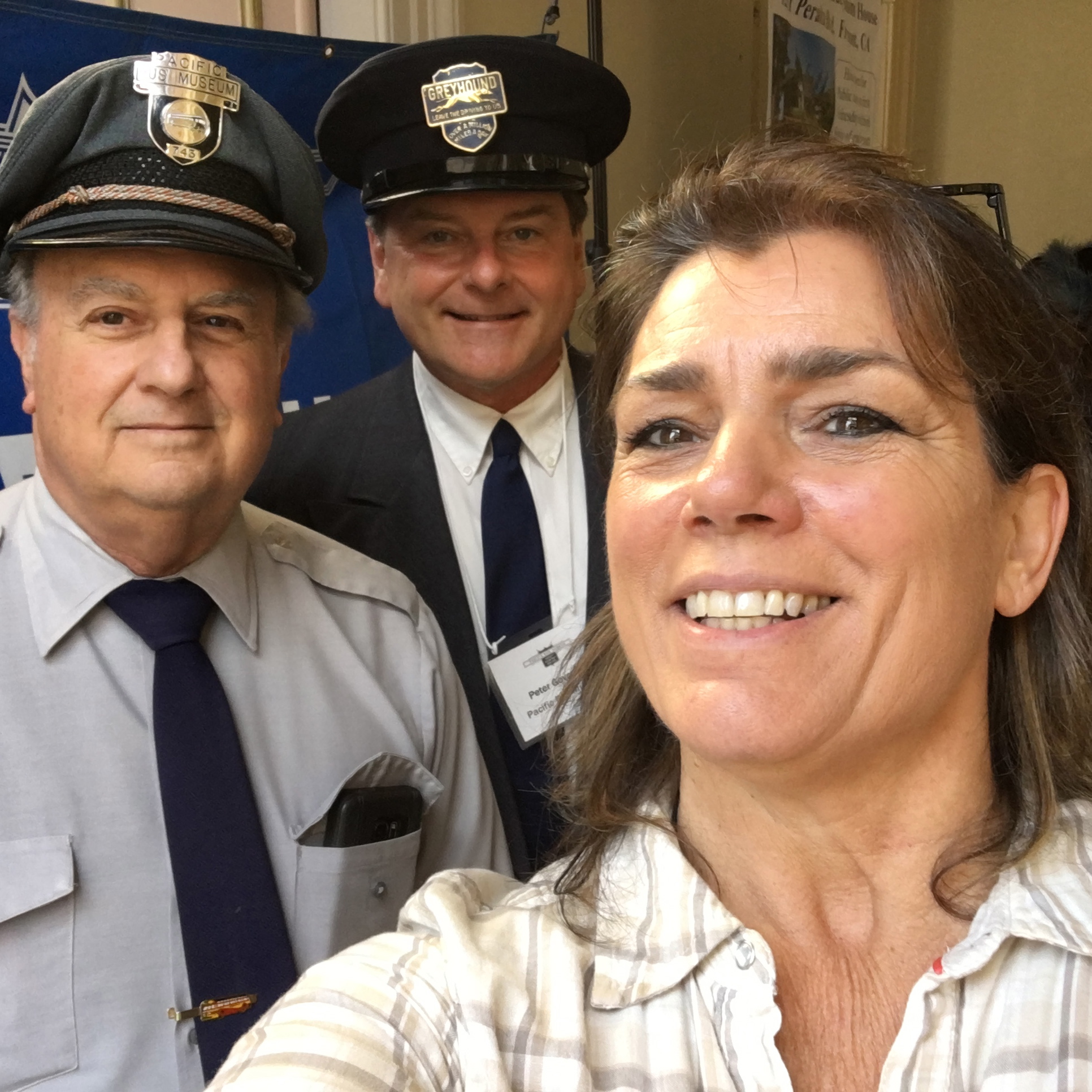
San Francisco History Days Vender — photo by Stacy Poulos Postcardtravelers.com
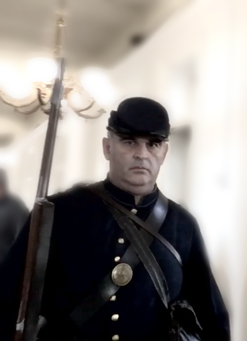
authentic civil war uniform – costume- photo by Stacy Poulos Postcardtravelers.com
Take a unique trip back in San Francisco time at the ‘San Francisco History Days’ held every year in March. Here, History enthusiast dress up in authentic period clothing to add to the atmosphere. There are many booths that represent Historical organizations and museums all over the Bay area. Mostly in SF. My favorite booth was the Pacific Bus Museum sense I have already have been there in Fremont. There were representatives from all over. This is a great resource for researching History, locations, actors, etc. there are endless possibilities all at the Old Mint, which is a vault as a perfect setting. “…dozens of organizations celebrating and telling the stories of the City’s unique past. We invite you to meet community historians, archivists, genealogists, archaeologists, researchers, educators, re-enactors, and other history enthusiasts at this FREE, all-ages weekend event at the historic site.’ (List of 2018 exhibitors)
Here is a little teaser video of what it’s like on the inside.
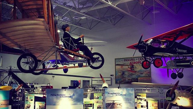
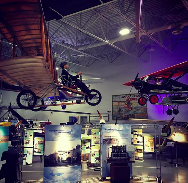
Visit Hiller Aviation Museum 601 Skyway Rd, San Carlos, CA 94070
(650) 654-0200
http://www.hiller.org/ https://www.facebook.com/HillerAviationMuseum
This is such a great place! Real airplanes hanging from the ceiling. Vintage airplanes and replicas of the first airplanes including ones that never left the ground. In their words: “The Hiller Aviation Museum engages the community in the human spirit of adventure, discovery and innovation. Through compelling exhibits and immersive programs, the museum provides a stimulating environment with multiple ways for public audiences to experience the adventure of aviation, its future promise and its history in California, and to use aviation as a gateway for exploring science, history and technology.” I’ll say! This place is great for kids and adults. Check out my live mini tour video and bonus video flying inside a PT-17 in a Air show for the Tuskegee Airmen. PT-17 were there Trainer Planes.
Live inside At Hiller Aviation Museum In San Carlos with Stacy Poulos PostcardTravelers
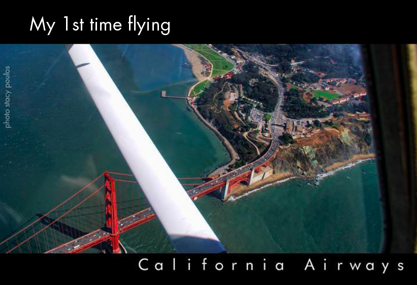
I have a lot of History with flying and I have a correction to make about this video, my grandfather George Stein worked for Hughes Aircraft where was one of the 3rd persons to fly over the Atlantic Ocean in the China Clipper (not 42nd as I stated in the video). He also worked on the Space Shuttle for NASA and engineered and modified old bomber aircraft planes so they can add new technology computers to them. His Company was Stein Engineering. At one point we had a wind tunnel built in our living room for NASA. As a child the 1st Airplane I flew in landed in the water; Catalina Seaplanes, I’m in love with them! Of course after I flew, in many commercial airplanes that landed on the ground. As a young adult I flew around Catalina Island in a Cessna 150 sword fish spotting, the Pilot let me take hold of the rains. Later I was one of the independent camera at the 1 Air Show Honoring the Tuskegee Airmen and interviewed the 1st Black Pilots of America and the 1st Black General of America Benjamin O. Davis Jr. Which also landed me to have the honor of Flying in the lead Airplane with the president of the Confederate Air force Milo Tichacek in his PT-17 (see the bonus video inside that flight!). Then I flew in the nose of a B-25 Bomber the gunner seat. Eventually upside down in a P-51 and a an old Beechcraft. I’ve also flown in the channel 5 helicopter, and a police helicopter. Whew! So as you can imagine I had the aviation bug all my life. Eventually I took a lesion with California Airways with Keith Amaro and got to fly over the Golden gate bridge in a Cessna 172! Basically; lucky, lucky, lucky, lucky …and lucky!!
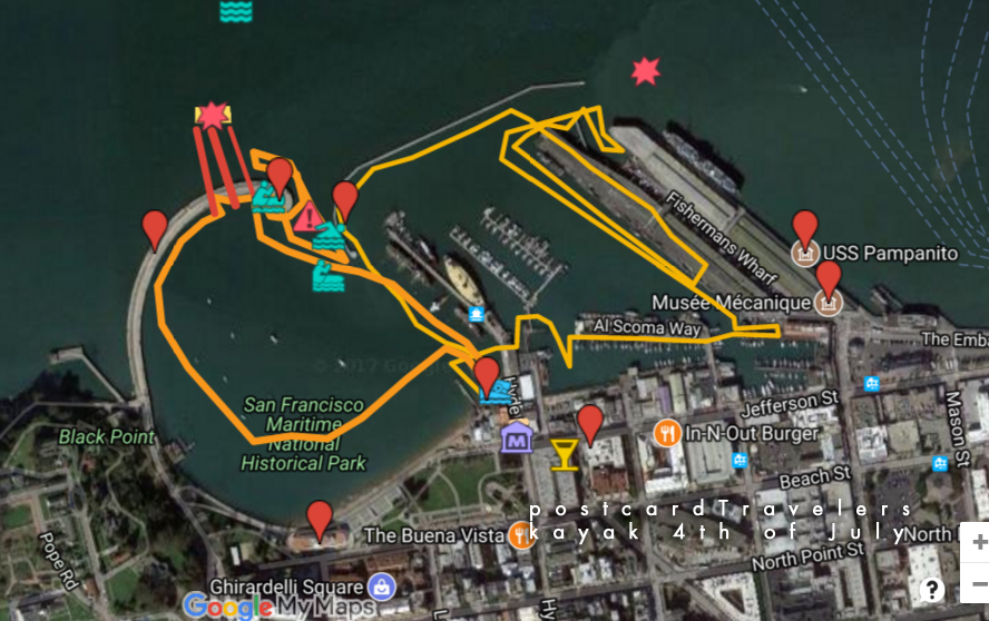
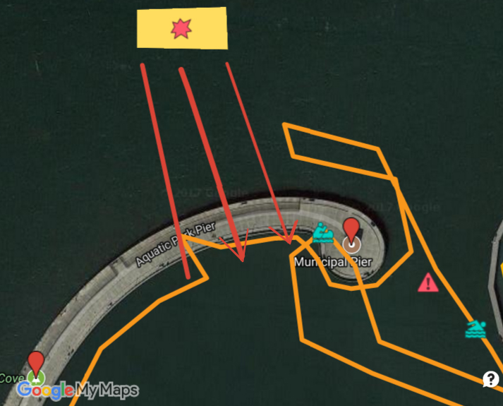
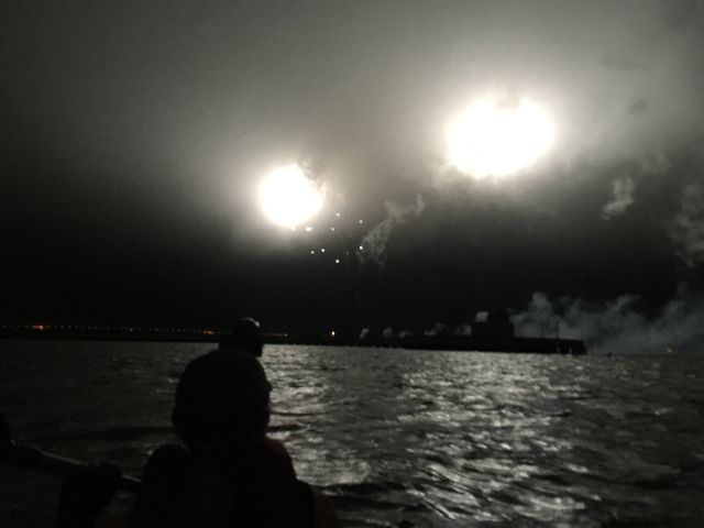
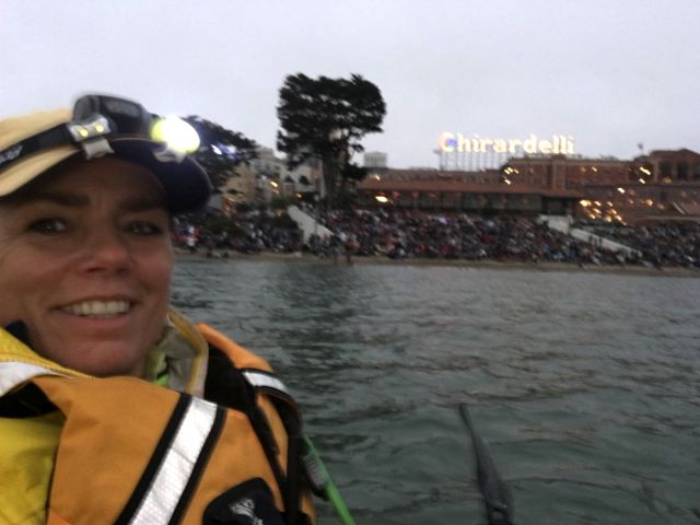
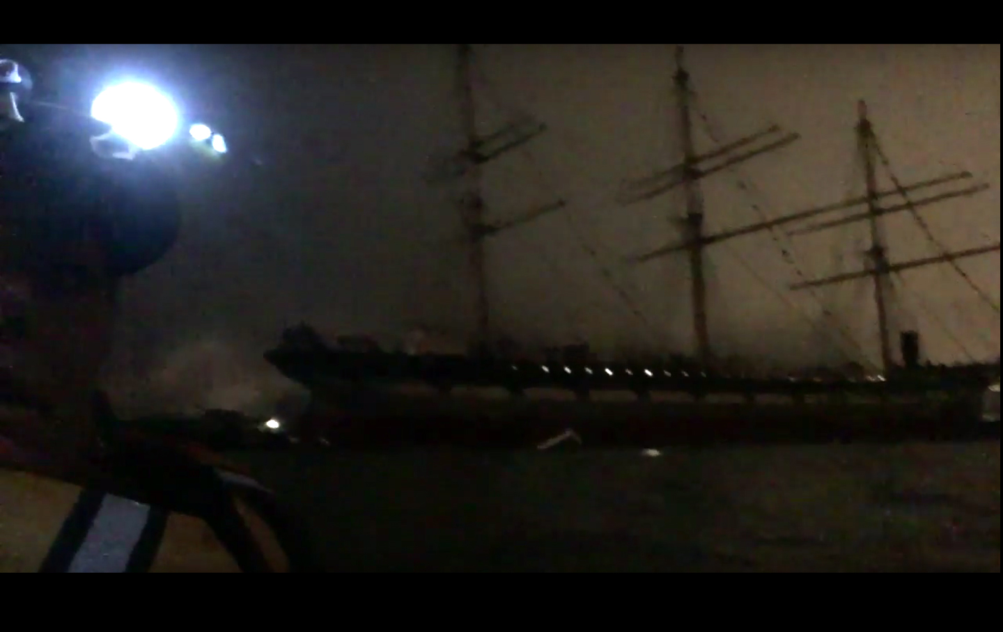
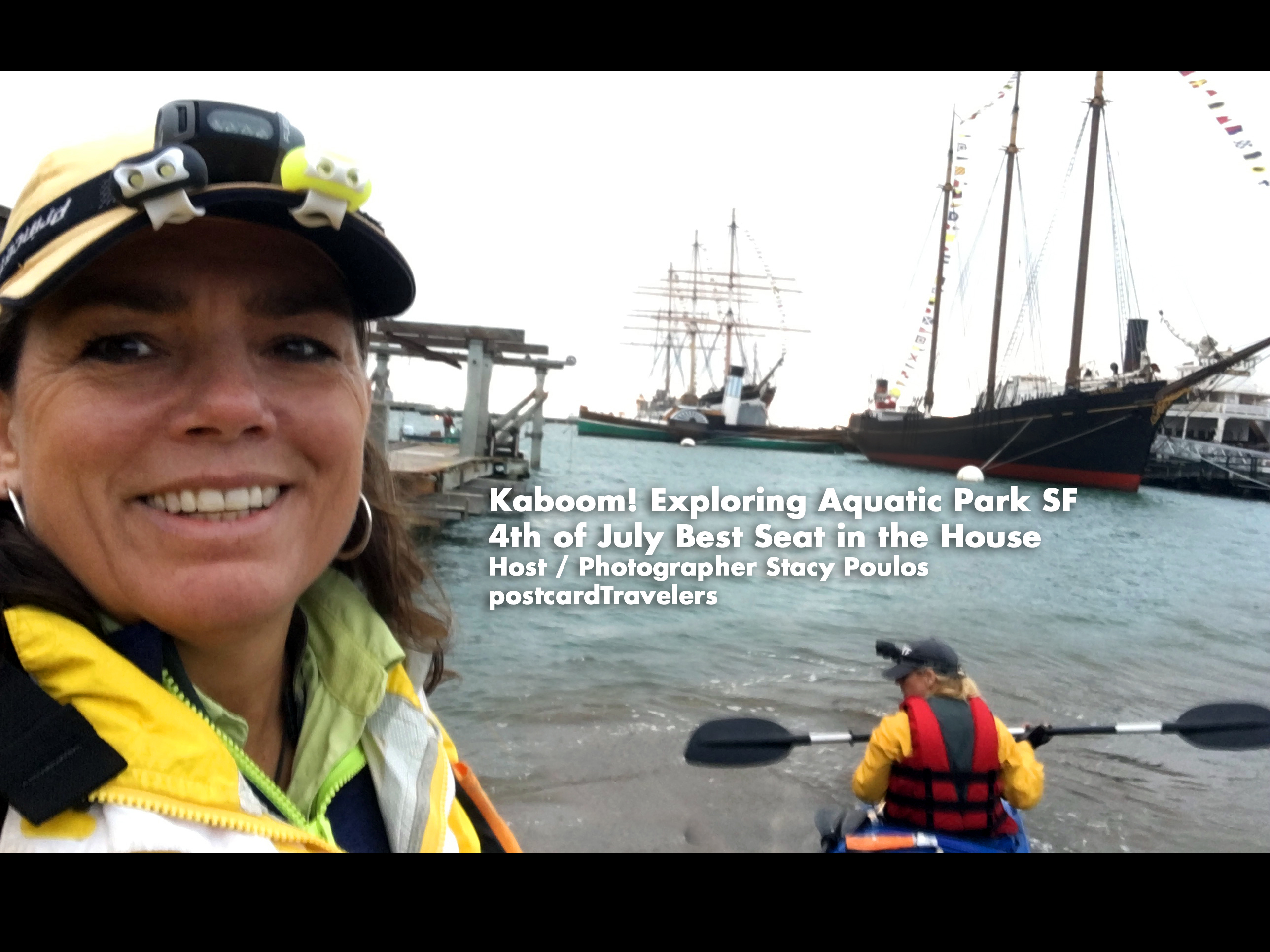
Kaboom! I can take this off my bucket list, being directly under the projection of the fireworks at the Aquatic Park Historic District pier! We put-in our boat and launched at Hyde Street Pier in San Francisco, California. Hovering under the pier A little too close for comfort, until the fireworks unsuspectedly started. The current kept making us drift quickly away so we hovered under the pier. We even had all our lights off to save batteries, so we were in the dark. The first echoing Kaboom explosionsunder the pier were un-describable. Enough to rattle your nerves! I was deeper under the pier being in the back of the boat looking out at Ghirardelli Square. *In this video I said ‘last time I got in trouble’. It was because I got too close to the Historic boats. There were no signs that I could see at the time. It is kind of roped off with buoys. This time we stayed further away out side the line. One way or another, I recommend this spot. During the day there is a live concert on shore. We had a back stage pass, a nice little additive to the day. The yellow box with the star is where the fireworks barge is. The Teal Green boater is where we hovered until the fireworks started.
fireworks projection san francisco Aquatic Park
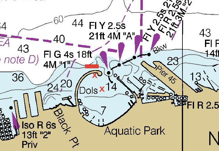
However, I don’t recommend right there. Much too close. Instead bring a anchor at least 20 feet long and hover at a safe distance like we are in the photo below. To the left and center of the park here we are look at the Municipal Pier a posed to being under it!
Live Concert at Ghirardelli Square 4th of July
So, planning for next year. I recommend going here. Be more prepared. I do own a kayak anchor. When I looked at the Coast Guard Map it said it was around 7-14 feet deep in the area but there is only one marker and I didn’t think my anchor was that long. Besides it being a pain to add more weight. Next time I will bring one for sure! If your planning on hovering in the ocean, there is always a current. Anyway, below is a live interactive google map with all my notes for 4th of July over the years in the SF Bay. If you click on any icon, it will zoom into that note. When you click on ‘Aquatic Park Historic District‘ And look at the orange line that was our path in 2017. To the upper left of the map are my notes, that little box’ie icon on the upper top left corner opens the notes, click on anything at it will bring you to the spot on the map. Bottom right is the + and – zoom button. You can then close the notes with the left arrow it to get the notes out of the way. I also have a layer of land notes, where I intend to go for a city hike and check out the same area on land someday.
Aquatic Park Historic District pier Ghirardelli Square 4th of July
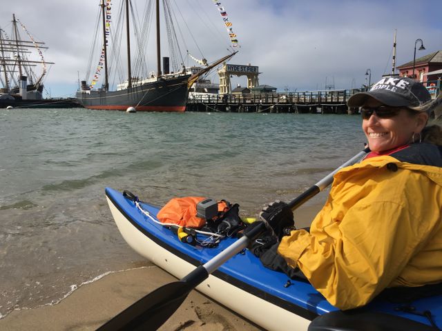
Launching on Hyde Street Pier AquaticPark. I’m not sure you can launch out of the museum. Since the public beach was full of people we couldn’t go their.
History of the 4th –
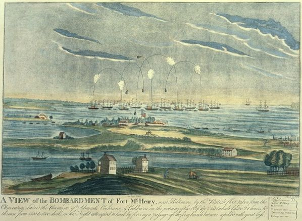
I think this is one of the safer and best spots in the San Francisco bay to view the fireworks from land or water. If you know the History of the 4th, or Independence Day and the inspiration to our National Anthem, you would know the 4th of July is meant to replicate what Francis Scott Key seen on that fateful day in 1812. He was a British lawyer on the French Ship; HMS Tonnant negotiating a British prisoner exchange were he was to negotiate the release of prisoners, during the Battle of Baltimore at Fort McHenry. (The only other place that can possibly top this spot). Key learned too much about the French’s attack on the British, so they kept him a prisoner as well. So all during that night Key witnessed the fireworks in the bay of Fort McHenry. In the morning when the fireworks stopped, and lack of communication the only way to know who won the battle was the American flag still standing. He wrote a poem “Defence of Fort M’Henry”, that later became the lyrics to ‘The Star Spangled Banner’.
So why is this the best spot? First of all, the Maritime National Historical Park is situated inside Aquatic Park San Francisco… in the water! There are period ships to set the perfect scenery of what the bay may have looked like. The ships are much younger in the park; like the Balclutha 1886 and the C. A. Thayer 1895 but look very similar. Add a dark sky with a silhouette of the old ships sails from the 1800’s lit up by fireworks, well you’ll get the picture and full effect. A lot of people don’t know this History, so why do I? I wrote a book report in the 4th or 5th grade about it. I found it fascinating that people were so affected and heart felt over a song, it inspired me to want to write music. So now you know. Now let’s let Key set the story and imagine the background.
Oh say, can you see, by the dawn’s early light, What so proudly we hailed at the twilight’s last gleaming, Whose broad stripes and bright stars, through the perilous fight, O’er the ramparts we watched, were so gallantly streaming? And the rockets’ red glare, the bombs bursting in air, Gave proof thru the night that our flag was still there. Oh say, does that star-spangled banner yet wave O’er the land of the free and the home of the brave?
SanFrancisco Maritime National Historical Park Fireworks Francis Scott Key, 1779–1843
So we won. And every year we celebrate this day in a grand way.
Reason 2, why it’s the best place to kayak on the 4th? The park is protected by a breakwater pier. However, that doesn’t mean there aren’t strong currents, but it’s a protected area and larger boats can only go 5 mph. There are actually crazy swimmers swimming at night. There are police and coastguards near by. Of course if you don’t have a walkie talkie that wont do you any good. So it is most watched by land and sea.
Next good reason, the fireworks barge is directly on the other side of the pier and they project the firework into the park. Giving the people on land and sea one hell of a show! Wow!! We hovered under the pier until the fireworks started because the current was so strong it kept making us struggle to stay in one spot. On land you can walk and board the ships.
The depth in the park looks to be 7 to 14 feet deep. Of course I wouldn’t recommend where I was, the first fireworks rattled me to the core. Being under the pier echoed the effect in such away that you felt you were in a war being bombed. Not sure your supposed to be under there but we needed to be protected by the current. Eventually we let loose and drifted to the center of the park facing the fireworks and current. It was foggy as SF is, but it also had a unique effect in it’s self.
Dolphin Swim & Boat Club and South End Rowing Club
We Put-in at Hyde Street Park. I’m not gonna lie, I’m not sure your supposed to. I heard there was a public beach launch to the left of the photo but it was all blocked for pedestrians to view the show on shore. Since we got out next door to the rowing and dolphin club, I assume they assumed we were with them. Frankly it’s not fair there aren’t more safe put in areas for the public to launch. So you might want to try to arrange something or find out the real rules. We parked our car in the red zone on Hyde street, dropped the boat off onto the side walk, my friend parked the truck while I waited. We communicated through walkie takies, which I highly recommend getting water proof ones even if you don’t think you need them. You don’t want to kill your phone batteries trying to communicate and it’s a pain other wise. I will list my personal favorite things kayaking. Eventually we walked the kayak through the crowded street.
So, the park is not that big to explore a whole day, and if your going out side the park it should be done in much better conditions. You can putt around the park and see the ships below, just don’t get too close or they get mad. To the right / east, are docks you can explore. You can go in a area all the crab fishermen dock their boats. There is a lot of untold History in them, some barely afloat. Also before you get in the water you can actually go on these Historic ships for a small fee that supports our wonderful parks.
It was next to the Dolphin Swim & Boat Club and South End Rowing Club. You might want get involved with them to launch your kayak. We technically just walked through the Hyde Street gate and put our boat in. However the gate closes at 5pm, so you have to be out by then, or the gate is locked. You can technically still get out from inside, but not go back in, should you leave something behind. It’s a beach launch and even though it’s a protected area, there is a strong current when it comes time. How ever it’s protected and the current isn’t as strong as out side the park. It’s cool because you kayak next to old ships. Perfect setting for 4th of July. We hovered under the pier until it came time for the fire works. But be aware, even at 9pm at night there are crazy swimmers. We had the best seat in the house, with a back stage pass to a concert and being literally under the projection of the fireworks! Here’s a important notation it’s a beach launch, pretty mild. You go through the gates of the Museum and the gates close at 5pm. Most the people who work at the Museum are volunteers over 90, kidding. I don’t think they care.
However you can still get out because the gate is only locked for people getting in. So if your out in the Bay and need a emergency out, here it is. There is a public restroom.
To take a rest, we ended up landing at the Dolphin Swim & Boat Club. The girl sitting on the beach was really nice and helped pull us ashore until she realized we weren’t members cuz we asked dumb questions. Then her face turned unfriendly like we were on her property and said they don’t take to kindly to non-members. So we went next door, and went out the Row Club doors to the street. Much more friendly group of people. They promised they would let us back in to get to our boat.
We just wanted out of the water to rest. We just weren’t sure where to go, so we can come back to our boat. I just think it’s pure BS. 4th of July, land of the ‘free’ BS. Land of we own this, get the f’ off. When it comes to boating it’s dangerous to send boaters back out that need to rest. Or set their lights or get out of rough waters. We had struggled for a long time against the currents and wind, we needed to rest. I’ve got nothin’ for people that don’t help, sorry I disturbed your cozy picnic. I mean we are loaded down to kayak, do we look like we want to stay here? All in, all. There were only 4 kayakers besides us, anyone who really kayaks wouldn’t go out in, apparently, gusting winds which I wish they would say MPH, which is 16.1 to 19.6 MPH. Gusting means ‘gusting’ temporary burst of wind. Ok got it! Ya, so I’m learning as I go. Anyway, take that off my bucket list.
Old Fishing Boat Fisherman’s Warf SF Stacy Poulos Photography
Anyway, once parked we went across the street to the fancy Blue Mermaid Restaurant. I looked like a Uni-bomber with my kayak vest still on, walkie talkie, pilot knife. I had coffee while my friend had oysters and beer. Absolutely beautiful restaurant. I must go back. Anyway, all in all it was such a great evening. After the hair raising fireworks, Instead of leaving immediately, we loaded up the car with the boat, parked then went to a bar Jacks Cannery Bar for a night cap to let all the traffic go away. Sucks having to drink expensive beer (cash only) out of a plastic cup, when you just risked your life, I don’t know how many times… welcome back to land. But there was a mixed group of out of town’ers fun to chat with.
Below I listed some of my favorite things kayaking.
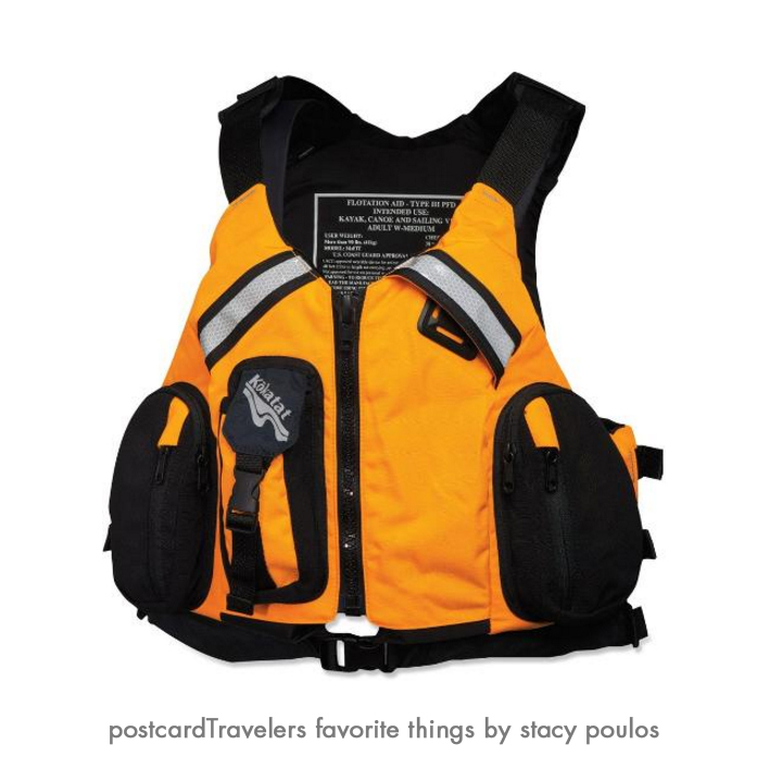
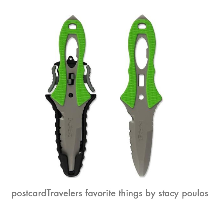
#1 My Kokatat MsFIT Tour PFD – Women’s Life vest.
I love the walkie talkie pocket and the front stretch mesh pockets to stow essentials. The pocket are not water proof. But when I do put things in the pockets, they are in plastic in need be. The deep-cut neck and armholes maximize range of motion for my arms, there is a difference! I used to kayak with a ‘water ski jacket’ and it gave me rub burns under my arms. Your life vest is –your LIFE Vest! It’s a investment. Having things on your body and not hanging from your neck it super important. If you capsize you have less to get hung up on. Chapsitck and sunscreen and cell phone is in the pocket! However, getting back in the boat you have the pockets to contend with. Kokatat is a great brand, when I went to The Travel Show, a pro Kayker had one and she gave me a personal tour of her’s and she swore by it. I had my eye on it the first day I seen one. They are all very adjustable in size. I have a Large. You can say I’m smitten by mine. It also has a ‘Strobe lash tab’ I guess thats what they call it. Anyway, you can attach other things to it, for me I have my Rambo ‘NRS Pilot Knife’ which I love. There is Reflective tape on the back and chest. You never know when you will be out at night fall.
I will get more into products I love in a dedicated blog
Kokatat MsFIT Tour PFD Women pro favorite My NRS Pilot River Knife (Rambo) knife is always ready for action. It’s 3 inch stainless-steel blade with blunt safety tip has both smooth and serrated cutting edges; matte finish with a are hole in the handle that serves as a valve wrench for an oxygen tank a bottle opener is built into the handle. Comes in handy for many uses.
My NRS Pilot River Knife (Rambo) knife is always ready for action. It’s 3 inch stainless-steel blade with blunt safety tip has both smooth and serrated cutting edges; matte finish with a are hole in the handle that serves as a valve wrench for an oxygen tank a bottle opener is built into the handle. Comes in handy for many uses.
Motorola MS350R 35-Mile Talkabout Waterproof 2-Way Radio (Pair)
This is one of my favorite products. You think, everyone has a cell phone why not just call? You don’t want to ware out your cell phone communicating out on the road, trail or water. I use them everywhere! Hiking, kayaking. Used them in Europe to talk to my friends. Hands down best buy. They have a charging case so you just place them in the cradle after a long day. My mom got me mine for my birthday. You don’t want to dial and wait to ring, you want to send your message.
Ad a whistle to your vests, (super important) and your good to go! The whistle replaces a horn on a boat. I’ve actually been hit by a big boat, not dead on but swiped the side of my kayak. Having a whistle can help you let them know you are their since we sit so low in the water.
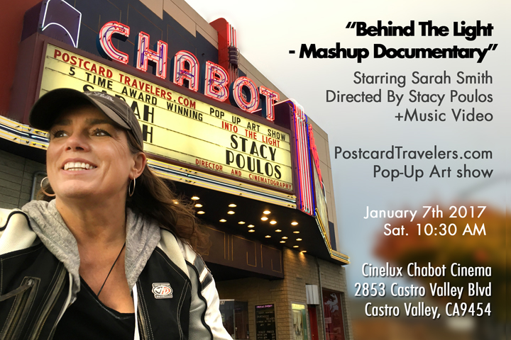
“Behind The Light – Mashup Documentry” Starring Sarah Smith +Music Video January 7th 2017 10:00 AM PostcardTravelers Pop-Up Art show Produced & Directed by STacy Poulos
42 minute film
Join me and distinguished guests to see the “Behind The Light – Mashup Documentary” (42 minutes) about the Five Time Award Winning Music Video “Into The Light” By Sarah Smith directed by Stacy Poulos on the big-big screen! Plus Pop-Up Art Show. Anyone in the music, TV, or film industry will appreciate the journey and be inspired.
Doors open at 10:00
This is a Free show!
We have a suggested donation of $5.00. Funds will go towards finishing up the project and for Film Festival expenses.
Judea Eden will be opening the show with a Solo performance in the Theater at 10am
Doors will open at 10:00 AM for a preview of the pop-up art show of Stacy Poulos Photography from around the world including a small island in Haiti where we will have a distinguished guest who lives there.
Video presentation starts promptly at 10:40 AM please don’t be late!
Other prints include water front photography from around the SF Bay, Greece, Italy and many more.
5×7’s are $30.00
8×10’s $50.00
11×14’s 90.00
We accept cash, check and visa.
Want to contribute and can’t come, or want to make a donation so you don’t have to haste with it at the show? Click here.
Print will be available for sale after the show inside the lobby and next door.
After party at 12:30, people visiting from out of town are welcome to go to Krayon’s Gallery.
If you can not make it, there are prints available at Bodies Java on Castro Valley Blvd. during their business hours.
5×7 = $30.00, 8×10 = $50.00, = 11×14 $90.00 Tax included.
If ordering $7.00 flat for shipping no extra charge for multiple prints.
Orders or Intrested in me having a show at your event? Private message me on PostcardTravelers
Enjoy a fun filled day in Jack London Square during the “Jack Of All Trades” show outside Lungomare’s. Inside Lungomare enjoy the food, drinks and Art show of Stacy Poulos Photography.
Stacy’s goal in 2011 was to take photos around the rim of the SF Bay from a kayak. Since, she has covered a lot of miles including San Francisco, Fremont, Sausalito, Oakland, Richmond, Point San Pablo. To name a few. In her journey she has recorded Historic dilapidated docks, 2 ship wrecks above water on from WWII and 100’s of other photo opportunities including filming under the Golden Gate Bridge, Richmond, Dumbarton, and San Mateo Bridges. An adventure like no-other in the SF Bay. Angles and unique nooks that can only be captured by kayak.
In the meantime, the Architect designing Lungomare encountered Poulos photo and design the restaurant around it. You can see it in the main dining room.
This day we will be celebrating her achievements in the most recent 5 time award winning song/music video she directed ‘Into The Light’ By Sarah Smith. https://www.youtube.com/watch?v=L7ML_FMhKgo
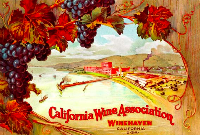
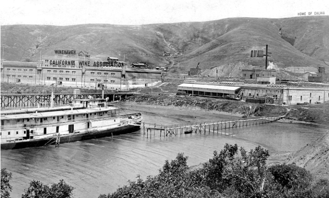
I’m always astonished how much rich History, or HerStory, there is right under our noses in the San Francisco Bay Area. I explored the waterfront area of Richmond by land and sea in search of what was once the largest Winery in the world when the California Wine Association moved from San Francisco to Point Molate Richmond after the San Francisco Earthquake in 1906. It remained the title of “World’s largest winery” for 12 years!! (1907–1919). Until prohibition crushed it’s demise and was shut down in 1919. Really, THE largest? Over Italy and France? Yep, it’s true. Now it’s an abandoned ghost town once called “Winehaven California” (It is in the U.S. National Register of Historic Places) and it’s castle remains in tact north of the Point Molate Richmond. Stenmark Drive is the last exit before you get on the Richmond Bridge and it is littered with a extraordinary and riveting California History.
The largest Wine producer in the world for 12 years.
If you walk on Pt. Molate Park Beach facing the water Winehaven would be to your right, around the corner less than a mile away, you can’t walk to it on the beach, but you can see it. If continue to drive on Stenmark Dr you can see the backside through the fence from the road. There is a bit of a battle to what they are going to do with the area. In my humble opinion, it is rare to be able to boast the ‘largest in the world’ of anything, let alone the most prestigious commodity of wine! So. I say restore the castle and keep boasting! But there’s more.
Winehaven 2036-2040 Stenmark Dr. Near Point Molate Beach Park Richmond, CA
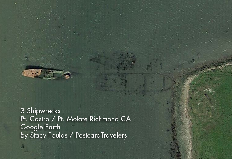
From that same beach, to your left walk 1,000 feet towards the Bridge to Point Castro and there is a 200 foot shipwreck, with half sticking out of the water even at high tide. (There are actually 3, if you look at Google Earth. 5 If you look at lowest tide.) With the completion of the bridge in 1956 the car-ferry service and inner city railway that resided there eventually rendered the pier useless and became a fishing pier. After years of lack of maintenance, it is now a barley recognizable battered pier. This once thriving corner of the Bay, is now a water front ghost town, mostly restricted from the public. For me, it’s a photographers dream. There is a public park you can enjoy where you can see the shipwreck. A 160-foot medium-endurance cutter patrol vessel ‘The USCGC Hermes WPC-109’ it was a Thetis-class coastal patrol ship in service from 1932 to 1958. It was assigned to San Pedro, California, and spent World War II watching for Japanese submarines, as well as escorting convoys out of the harbor. After the war, it was used as a stationary training ship. And was to serve as an enforcement vessel for Prohibition. A model is on display at the LA Maritime Museum. Hermes also served to deliver an important marble Cabrillo monument January 1937 to the San Miguel Island in the Southern California. In honor of Juan Rodríguez Cabrillo (Portuguese: João Rodrigues Cabrilho; c. 1497 – January 3, 1543) who was the First European explorer in California where he laid to rest. And yet another part of our Rich History.
The Hermes vessel was decommissioned November 2, 1948 and sold May 16, 1958. Eventually laid to rest where it is now, Point Molate. She still sits with her bow in the air above water, surrounded by unnamed shipwrecks beside her, slightly below the water line. You can see them on google earth, and on a lowest tide you can see them even more. It is a dangerous area with pilings sticking up.
Just know it is windy out there facing the Golden Gate. If it’s a date night you can start here and work your way back to end up at the wineries near, The Riveter Rosie Museum. To me it’s crazy this area is not as explored as it should be. And I pray they do not develop this but to bring back what was there.
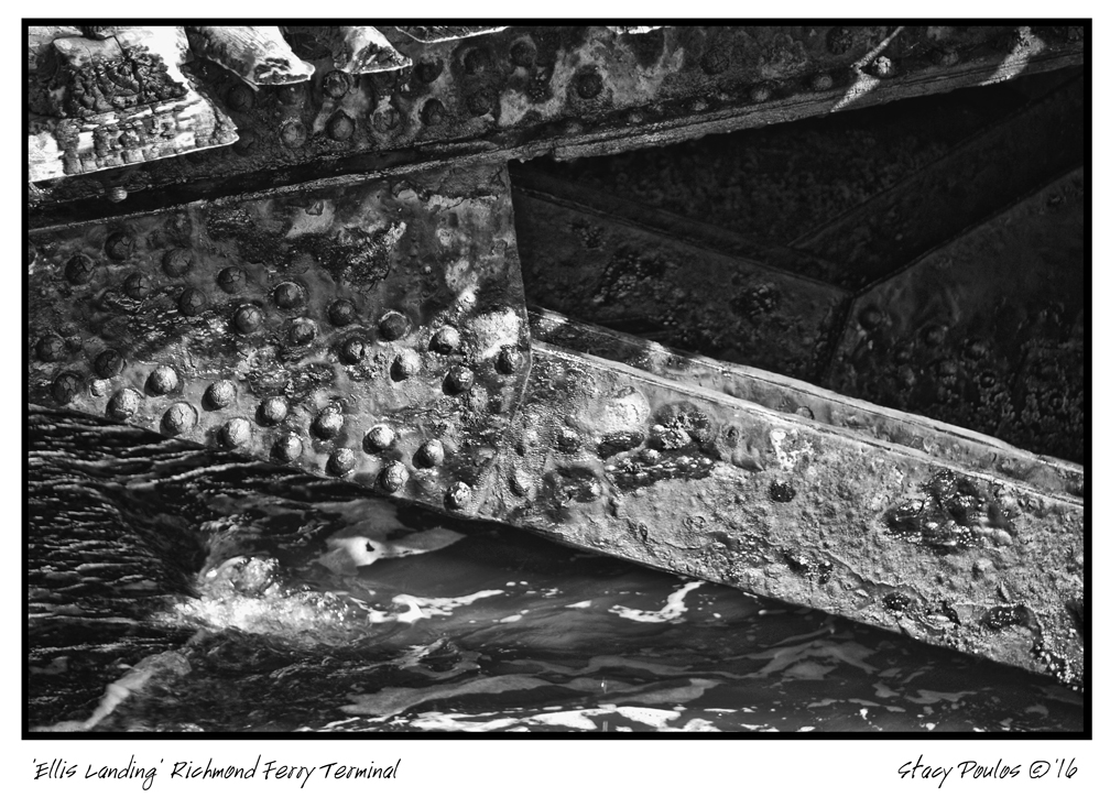
Point Richmond Ferry Terminal (aka Ellis Landing)
Point Richmond Pier
Next stop is Miller / Knox Regional Shoreline at Point Richmond on Canal Blvd. At the very point, is a gutted out building. And a fishing pier which. Along side the new fishing pier is a dilapidated pier that used to be a commuter ferry service to the San Francisco Ferry. You can see where the train rails lead to the terminal which now are broken and lead underwater. I actually kayaked under it. Besides being broken-down and battered, it is clear there was a recent fire that further damages the battered pier. For me, it was the highlight of my 2nd kayak trip. It is said, it is at ‘Ford Point’ however you can’t find it on the map. Something I have found over time, places are renamed and it really depends on who you ask. It’s name came from the historic Ford Plant. But you put in ‘Point Richmond’ and you will find it. There is a whole walking tour of the area with points of interests. Across from the Museum is R&B Cellars where you can wine and cider taste and have a bit to eat while you enjoy the Bay view.
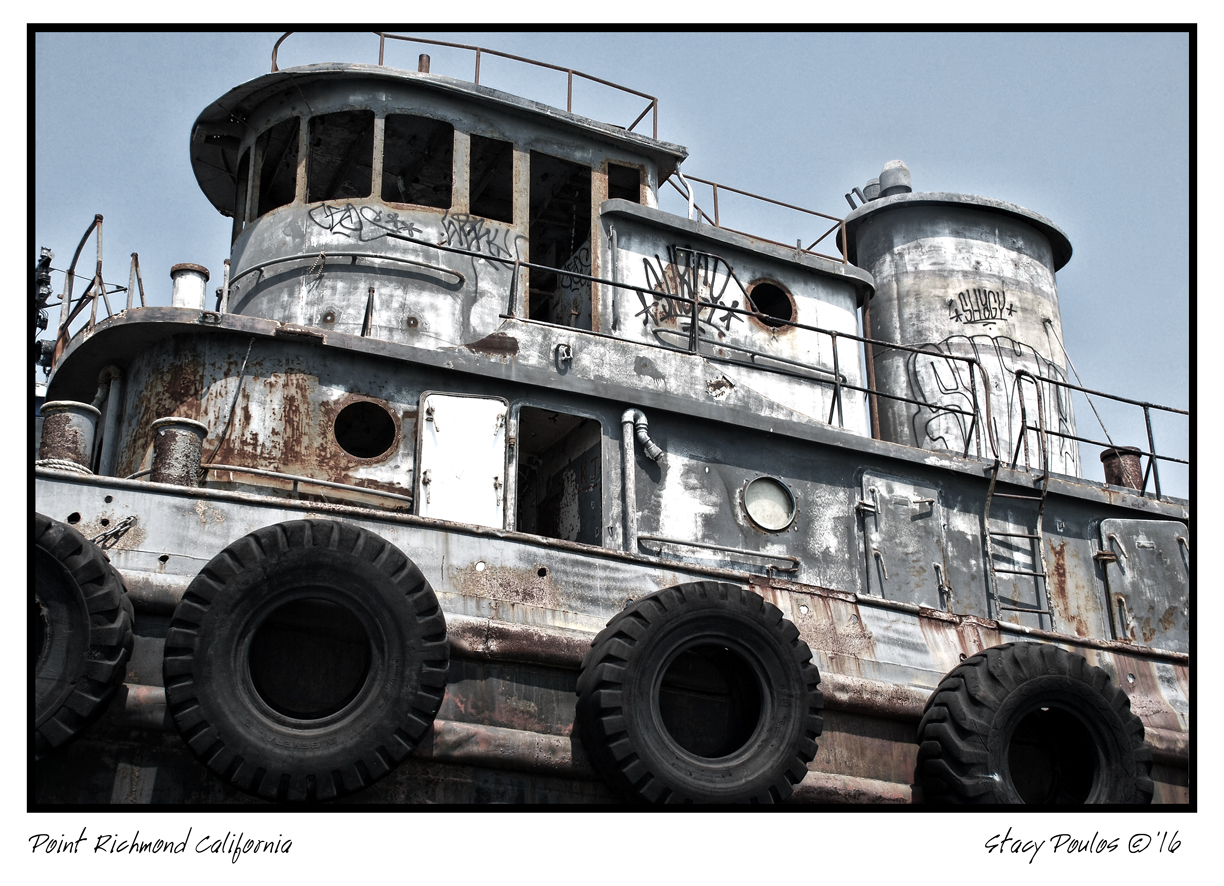
Now it’s time to warm up and get out of the wind. Working your way back go to see the inside of the SS Red Oak Victory ($10 donation to get in, mostly Closes at 2pm). I have not been inside yet, however I have been under the massive destroyer it in a kayak. It’s A original ship made by the Rosie The Riveters. If you aren’t familiar who Rosie is, during WWII all the available men were summoned to fight the war with no one left to build the Ships and Airplane’s. So women were summoned to come work in the shipyards. There is a famous print by Norman Rockwell that advertised “You can do it” to encourage women to join the movement where the women, who other wise were expected to be housewives were summoned to work in the shipyards. Back in those days it was ludicrous a woman would do a “man’s job”—even if they wanted to. Rivets are basically like ‘a nut and bolt’ a all in one, permanent mechanical fastener that holds metals sheets together to make airplanes, ships, bridges and such. They did more than assembled them with rivets, they welded and did all types of non-traditional jobs. It was war-time and Richmond area was the largest producer of war time products. The rural City of Richmond exploded. Now the whole area is dedicated to preserving this HerStory.
Shipyard Trail General Warehouse Richmond 2016 By Stacy Poulos
1414 Harbour Way S #3000, Richmond, CA 94804 (510) 232-5050
After seeing the ship, go to the Rosie The Riveter Museum, it’s very tactile with life size people to give you a sense of that time. Maybe even go home with a lunch pail. Especially if you have kids, they should see how woman contributed to the war effort. The Museum is free but if you can spare it, donations are always appreciated.
Now that you’ve had a day of HerStory, reward yourself at the Assemble Restaurant you basically get to eat and drink in the boiler room of the Ford Assemble plant.
Assemble Restaurant @ The Craneway Pavilion, 1414 Harbour Way S, Richmond, CA 94804
Now you have a choice to call it a day and watch the sunset there, or go back to see the sunset over a Pirate Harbor. Yep, a pirate harbor only you me, John Wayne and and a few others know about. If you continue on back on Stenmark Dr. past Pt. Molate Park Beach make a right onto a dirt road to San Pablo Yacht Harbor or they like to say San Pablo Pirate Harbor. They have developed the area in such a what that its very artiest friendly environment.
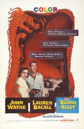
Follow the ‘Point San Pablo (Pirate) Yacht Harbor sign. There are is a public bathroom and public kayak launch. But this little eccentric cove has a long History. Is was originally made by By Captain Raymond H. Clark in 1939 lined up about 9 ships on both sides to create a breakwater Harbor eventually overtime the ships were covered with dirt. And yes, that’s what you walk on.. shipwrecks. Fascinating. At sunset, at least on this day was a golden calm. At one point in History that area was the setting of the movie ‘Blood Alley’ with John Wayne and Lauren Bacall!
Update! There is a quaint restaurant you’ll have to figure out what they have there now. Here is a link: https://www.pspharbor.com/ I promise you explore this area by kayak, car or foot, you will not be disappointed!
Point San Pablo Yacht (Pirate) Harbor
Many buried ship wrecks
1900 Western Drive, Richmond, CA 94801
+1 510-233-3224
1955 ‘Blood Alley’ with John Wayne and Lauren Bacall partly filmed at Point San Pablo Harbor.
Stacy Poulos, Randy, Lisa and Tanya Holland Brown Sugar Kitchen
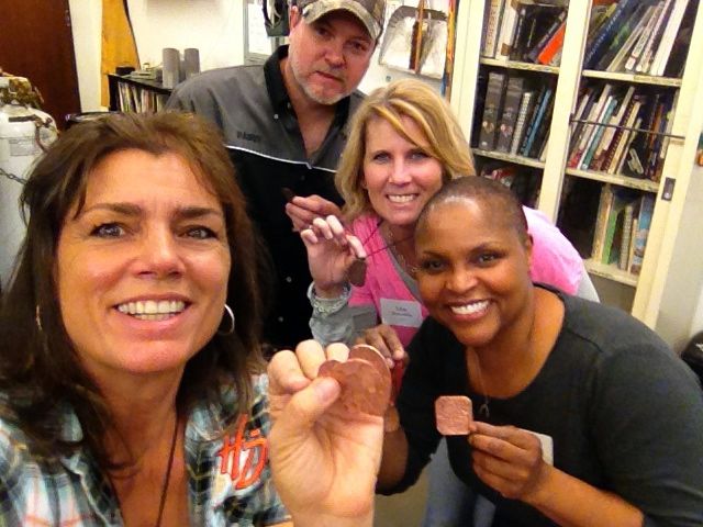
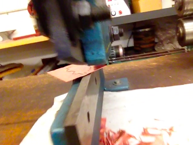
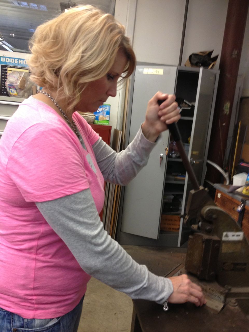
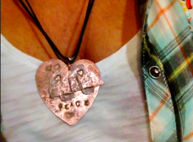
The Crucible is one of the Coolest places in the Bay Area, no kidding. Here you can exercise all your creative juices. This is my second time. We took a jewelry class and I made a reckless out of 2 pieces of copper. Fun! Annnnd to my surprise, Tanya Holland, owner and Chef of the famous Brown Sugar Kitchen was taking the class with us.
Ok, I know, The “Crucible”?? What does that mean?? Well one of the definitions is; ‘…a place or situation in which different elements interact to produce something new….’ Well it’s Blacksmithing, Machine Shopping, Ceramics, Mold making
Enameling, Neon & Light, Fire Performance, Artist Resources
Foundry, Stone Working, Glass work, Glass blowing, Soft Sculpture & Textiles, Hot Wheels, Welding, Jewelry, Woodworking, leather working, Kinetic & Electronics… whew… and more! As a creative person, it’s everything you wish you could do. With a impressive fire arch you walk through to get in. To all the displays of artistes works displayed. Classes are for all adults and youth. Try to make it on a open house so you get a tour. When you come back, you are going to want to thank me. (How ever make sure you don’t leave anything important in your car the are is in a warehouse district). http://thecrucible.org
Thank you Randy and AB&I for inviting me again! AB&I is a big support of the Crucible.
Car enthusiast? Never miss a Goodguys Rod & Custom Association event. They are all over the Nation. Today they were in Pleasanton California. I love the swap meet part; old and new nostalgic stuff. There are demonstration 100’s of booths, food entertainment, cars for sale. It’s pretty inexpensive to go.
Here’s a mini tour. https://www.good-guys.com/
I’m excited to announce I have 2 new calendars. You pick the month you want the calendar to start! Here is the ‘San Francisco Bay Area Shoreline Wall Calendar’ Buy it here, support a photographer http://www.cafepress.com/postcardtravelers.1473219303
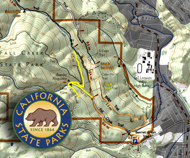
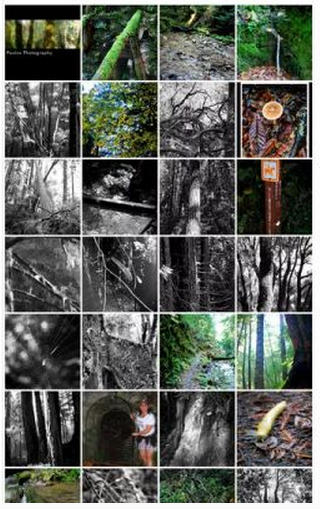
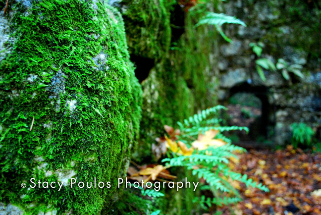
Moss Banna sluhg Fall Creek Trail. California State Park, Felton, CA
Not so deep in the woods of ‘Scotts Valley’ is a lush forest of Mossy trees in Felton, California. The broken ones that lay across the ‘Fall Creek’ of Henry Cowell Redwoods State Park trail and forest floor are as full of moss, as the ones standing tall gasping for sunlight. We took a short hike about 3 miles round trip the day after Thanksgiving to work off the trimmings.
Fall Creek Map
I can only equate my experience to the lush forests as the forest on the Hilo side of the big island of Hawaii; Lush. I learned one time in a movie you can tell which way was ‘North’ since the north side doesn’t get as much direct sunlight (If it gets any at all). Of course this is scientifically confirmed (not) with wiki answers. I suppose it depends where you live. “In northern latitudes, the north side of trees and rocks will generally have more moss on average than other sides (though south-side outcroppings are not unknown). This is assumed to be because of the lack of sufficient water for reproduction on the sun-facing side of trees. South of the equator the reverse is true. In deep forests where sunlight does not penetrate, mosses grow equally well on all sides of the tree trunk” -IndianaHoosier / yahoo answers. Unless your in the middle of ‘Fall Creek’ where the sun can only peak through for short moments to some spots of the valley floor, there’s no way of telling which way is north, because moss grows every where, all sides. All kinds of moss and fungi. Until you get your blood flowing from your hike, you are going to be chilly, chilly as the damp, cold and dark environment it takes to grow moss.
Fall Creek; Calif State Park; Felton, CA
I was with my cousins, my youngest cousin 13 years old taking photos, as I was; at the Intricate details from banana slugs that stood out like a sore thumb in the dark fall colors, to the contrasting images of various mushrooms and fungi and yellow fall leaves. In fact if you’re a science teacher and want to take kids on a nature walk to point out different fungi as a challenge this is a great spot. I don’t know much about fungi accept to avoid it. But I had seen more than a hand full of different types. The valley floor is sound deadening, quite and peaceful. If you settle down enough to listen, your own voice sounds different to yourself, you can hear crackling of wood from settling trees, creek beds trickling, and water drippings, distant visitors approaching. Once in a while you may hear a wrestling in the trees; hopefully not the native bob cats.
Fall Creek Trail. California State Park, Felton, CA
I don’t have a lot of experience hiking but the worst hike I went on was when I went 7 miles; a great deal of the hike in the heat of 90 degree weather 75 percent of the time in direct sun. We internally begged to get to the next little oases of shade to gather our strength to carry on. I can see having the ability to hike twice as long here because you are covered by trees. I think that’s the trick. Water and shade! I can’t imagine this would be a tough hike in 90 degree weather being so close to the Pacific ocean and out of the sun.
A mile and a half into our trip we were rewarded with a scene that resembled something out of a Indiana Jones movie; abandon limekilns from the 1870s decaying into the mossy forest. Slightly camouflaged with blankets of live and dead leaves, canopies of moss, rivers of dirt covering what was once tracks of wood beams for a tramway that carried tons of lime from ‘Blue-Cliff’ a 150 foot high quarry to the kilns.
Henry Cowell was from Massachusetts when he was enticed by the lure of the gold rush in California. This rush infused a high demand for construction, eventually he found his riches in the
Fall Creek Trail. California State Park, Felton, CA
building materials key ingredient –limestone. The key ingredient used to make mortar for brick buildings. Limestone itself is formed from a bed of sea shells layered and changed from heat and pressure from millions of years ago. More evidence of a even greater History.
Here in lies the lime kilns 1.5 miles into the forest from Felton Empire Road; the graveyard or headstones to an era in California’s History. Lime kiln’s are used to produce quicklime through the calcination of limestone (calcium carbonate). The chemical reaction takes place at 900°C to 1,000°C+. Burning 24 hours a day for 3-4 days. Hard to believe in this cool, thick forest was a thriving / bustling factory that made Codwell the richest man in Santa Cruz at one time, as well as the mortar that held parts of California’s buildings together, still today. A grave site of only remembrance of the road that was once the path way to deliver the lime that built California. It seams now the banana slugs are the rich ones.
I love a hike that has a appreciation for History, beauty, nature and a sense for adventure. As my cousins move on through the forest trail and I take photographs of all the intricate details, I think how blessed I was to have been gifted with this kind in attention to details, so many details. As I wonder, and I wonder. Looking for what is disguised or swallowed by nature. Shortly up the road I finally under stand what ‘Powder Magazine” meant on the map, as I thought it was strange to have a path named after a magazine? ‘Powder magazine’ was actually a housing for the explosives they used to break up the limestone. Like any mystery, the poorly labeled map only becomes a treasure map of what only your imagination can fly from when you are actually there discovering for yourself. For a short run it’s a great and adventurous hike. Of course you can carry on up the hill and make it a 7 mile if you want, but who knows what’s up there. Who knows what is buried underneath the discarded limestone.
The park features Redwood Grove, Douglas fir, madrone, oak and a stand of Ponderosa pine. The northern area (Fall Creek) is 2,390 acres, with about 20 miles of hiking trails. The tallest tree in the park is about 285 feet tall and about 16 feet wide. The oldest trees in the park are about 1400 to 1800 years old. Zayante Indians tribe of the Ohlone people once lived in the area, where they found shelter, water and game. (And moss).
For the details; there are no bathrooms and the trail head parking lot is hard to find so it’s best to set your milage counter before you start down Fleton Road. By Stacy Poulos
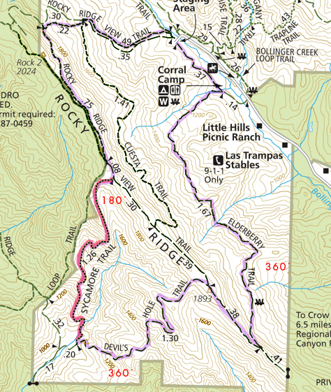
Ok Here’s the thing, I got my ass kicked yesterday. The good part about every mountain, is it hides the next mountain and valley you must walk through. So, when you think you have concord an extraordinary feat in your life, to walk the miles you have, you come to another clearing where you have an even longer and harder distance to go. Shit! I was thinking about an analogy of what I went through yesterday, when I was driving over the San Mateo bridge and seen a tiny distant light across the bay to my left thinking, that is where I’m going… in my car. Yesterday, it was on foot, times 10. That light was like the people ahead of me near the bend of the trail. Really!!?? ….that’s where were going! Again!!! Shit! I kept thinking, obviously I have no concept what these maps mean, or what 6.6 miles is in people feet walking. I was just proud as a graphic artist, I was able to highlight the proposed trail on my map. (I think my guide, who has the body of Jack LaLanne, also has no concept what a 4 in difficulty, means on a scale of 1 to 10 to out of shape people), like what 4 beers is to someone 180 lbs, is a lot different to someone 110 lbs. I guess it’s all relative, and I really need to qualify the situation a little better, if I live. People who make up these numbers should consider the delusion of out of shape people, who think they can hike. He was just concerned that it was 94 degrees high noon heat in the thick of it. Humm. [Thats it! …in my own mind… You think only ‘heat’ is the issue here, as I pant, grasping my stomach wondering what Turkey Vultures gonna get me when I’m left behind. As people drop off in the shade to bring there huffing down to a point of manageable blood pressure after a hiking some horrendous incline at a 500 feet incline back out of Devils Hole.] “Only 200 zig zag feet in elevation to go, he says” but look theres a shady tree up ahead.] Deeeevvvviiiils Holeeee, That! Should have been my first clue when I read the map. [“Oh good, Devils Hole sounds mysterious, this is going to be a great adventure. Wooo hooo, here we gooooo.”] Now I know why they call it Devils Hole, sounds like fun, but to get there, and out of there, you will feel like you have gone to Hell and back.
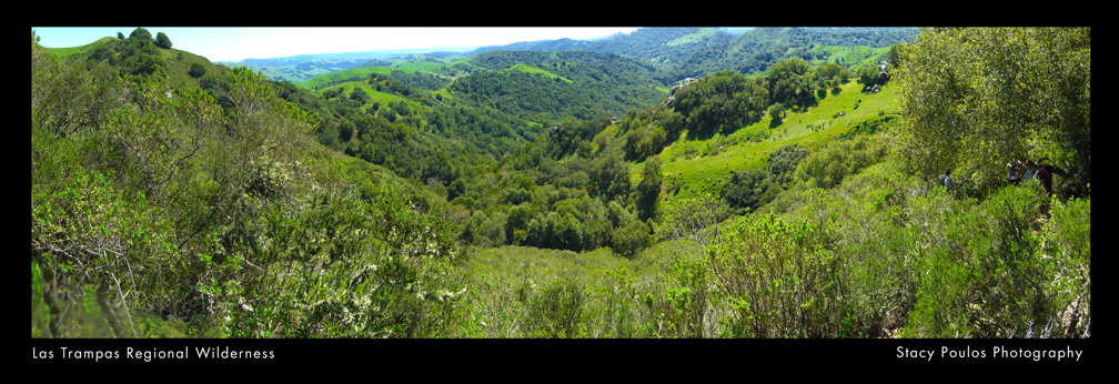
Devils Hole; To Hell and Back; Las Trampas Regional Wilderness By Stacy Poulos
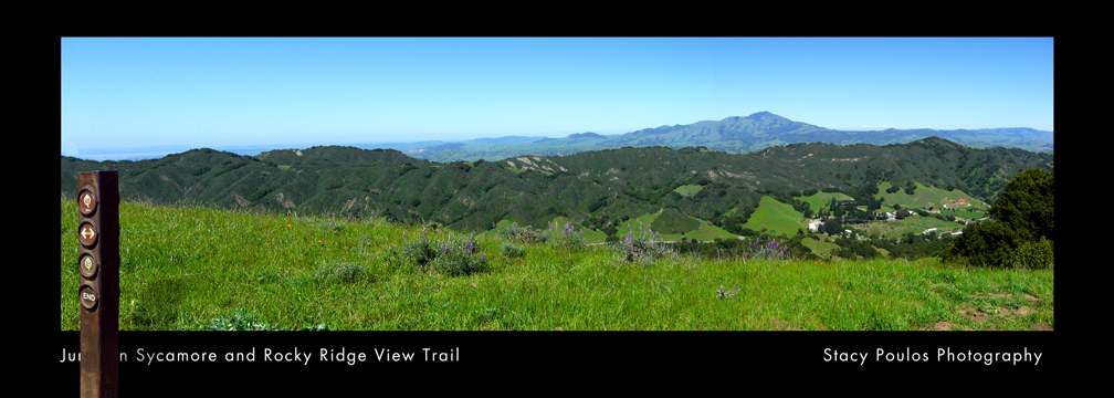
So, all kidding aside (not), it was; beautiful scene, after beautiful scene. Amazing this is in the heart of the East Bay surrounded by rural areas and city life. You couldn’t see any homes once you got to the other side, but a lake (San Leandro reservoir) with lots of green trees and brush, a few mountainy rocks and 60 miles in the distance you could see San Francisco smaller than a inch.
I chronicled my trip in photos, so when they found me dead underneath a poison oak plant, they would know how far and why I had past out. Besides our fall back group having fun plotting out how we were going to hold down the leader and kick his ass, if we lived to see the end, who now looks like a dot, on yet another ridge we must conquer. I thought to myself, self, thankfully America has the foresite to preserve these areas. And even though I’ll never see Devils Hole again, unless it’s on a post card, in my nightmares, or from a helicopter. I want to figure out how I can support State Parks more. If we’re to stupid to not enjoy them, we should at least make sure they are their for those who do.
Devils Hole; To Hell and Back; Las Trampas Regional Wilderness By Stacy Poulos
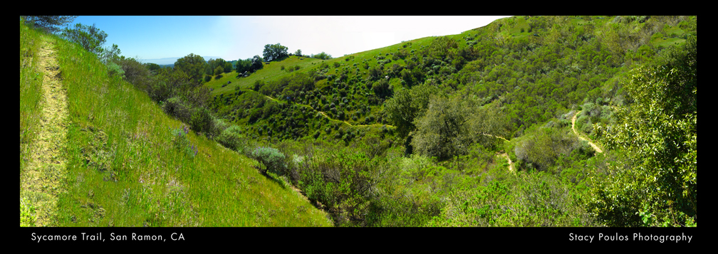
If you’re an in shape experienced hiker, you may like this hike. Our leader is a great guy and super nice. Maybe a little delusional about his numbers. I’d go to this kind of hike at any point …for a mile and that would be pushing it. Unfortunately you have to go to Devils Hole, to get to ‘Sycamore trail’ which is the best of all the trails. It was the most interesting to see, but the most treacherous elevation hike. It was under the most brush, which made the 94 degree weather not so bad for the hardest part.
For some one like me, I would take a trip like this if it was a 4 day hike. Hike camp. Hike, camp. Not all in one shot. We started with 47 people, all grouped up for the first quarter mile. Then our group spread out about a quarter mile apart in smaller groups. Me, taking up the tail with the fall back group, another couple who had a baby with them, and with another experienced woman hiker of this Trail with a old and slow dog. (My buddy). Who eventually split, before Devils Hole. (Our “Half Way point”). Obviously a wiser woman. ..another clue what was to come.
Being a mother Bear instinct myself, I was concerned for the momma and the baby, since I was huffing and puffing and had all my limbs to break a fall, she had to care for her daughter with one arm to protect her. There were a lot of situations where we had the luxury of two arms to get through some sticky situations and her only one.
So what else can I say? 24 ounces of water is not enough. I was out of water, when I got out of Hell. Once out of Hell, I would have paid $20.00 for a bottle of Ice cold gatorade. Luckily I had to new fallback people that were generous and well equipped that shared theres.
Before, I froze 3 mini 4 oz. collapsible containers, to keep my sandwich cool till lunch, great idea, BUT I think I miss read that to, it was more like concentrate, yuck. I thought of many inventions along the way, like a hat fan you clip on the brim of a baseball hat that is solar powered facing your face. Miniature handy wipe bags you can reseal.
At first I think, ‘what are these people doing bringing ‘back packs’, were going for a ‘walk’. Then I was jealous of all the amenities they had. Like our leader had an inflatable seat cushion to sit on. It was handy when we were in Hell lingering around having lunch, looking at Heaven. In light of wanting to sit along the hike, I thought an inflatable pair of shorts would be handy. Also the babies momma could have used a unit to keep her baby on her chest like she did, but not with such thick material and something to keep them cool and secure. One gal brought crackers and espresso beans to share, since I missed my espresso in the morning I indulged. She said she froze them so they wouldn’t melt. She’s not the only one who froze something, one man who supplied me with water after I ran out in Hell, froze his gatorade the night before. We ended up having more people join our fall back team who were welcomed with open arms. Especially with extra supplies!
Devils Hole; To Hell and Back; Las Trampas Regional Wilderness By Stacy Poulos
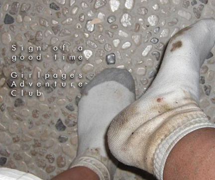
And for the record, if your going down and not in the direction of your car, your gonna to have to go up. In our case, up, and up, and up and up! If your wondering what those skinny unmarked lines that connect in circles from large to small around the trail you are on, they are mountains, the smallest circle is the tip. So, in conclusion, when you see several small circles on your trail, they will be the mountains in your way you will have to hike on, down, up and around. “W” means water incase your from Europe and think “W” means Water Hole as in bathroom. Ironically what seamed to be a little trail of Heaven on our last stretch, a easy paved road that seam to go straight to the parking lot, was the hardest stretch. Because of the steep decline put a lot of awkward pressure on your knees and jams your toes to the tip of your shoes. Even though I knew none of the 47 people I started out with, it was probably better that my friends bailed on me, they would have kicked my ass. I’m sure in a few days I’ll think I had fun, and forget I was paralyzed from the pain the next day and walked like a penguin with a stick up my butt for a week.
Devils Hole; To Hell and Back; Las Trampas Regional Wilderness By Stacy Poulos
But you know, I wanted my ass kicked really, I deserved it for letting myself get so out of shape in so many ways, when I’m a born athlete. I’m not going to be my true potential God intended me to be, if I let myself go so much as I had. I’m just not someone who can go to a gym andbreathe the air of others sweat, focused on just the workout. If God intended us to keep our bodies in shape at a gym,he wouldn’t have created the great out doors. So in a way, my leader was a Saint that took us in and out of Hell. The Hell we live for not getting out and seeing the world and respecting our bodies. Days like these, you think about who your are, and how you pollute yourself with unnecessary crap. (Maybe 6.6 was a little dramatic for my first day out) rubbing the skin off the back of my feet, jamming my toes and knees. Straining every muscle I have, especially the one between my ears trying to find a way out, a kebab I can jump on to kebab down the hill instead of walking it. A helicopter to pick me up and take me home to my mommy.
“All ails fails, read the directions” is our family motto. As I go back to review the website to see where I may have missed something, I read the the leaders profile for the 1st time. He says: “My experience level with hiking is very advanced – numerous hikes more than 12 miles, many with many, many thousands of feet of elevation change. …and am always pushing my hiking further – literally. That being said, I love to introduce new people to the sport, and can enjoy anything from very mild to ugh! level hikes. Between hiking, treadmill, and trail running my goal is to get in at least 20 miles a week of cardio, shooting for 25+ though!..” Well. Sigh! There you go. I followed a psycho hiker. Thank you!! I now have a Callus on my foot named after you.
Then I read The Sierra Clubs description “About this Trail… This is a 6.3 mile long loop hike to Devil’s Hole over Rocky Ridge. Enjoy lung-busting climbs to rocky ridges offering breathtaking 360 degree views of Ramage Peak at 1401 feet, Mt. Diablo at 3849 feet, the Ohlone Ridge out beyond Livermore, and Grizzly and Volvon Peaks dominating the Berkeley Hills horizon. Enjoy the wild life, eagles, hawks, and buzzing buzzards (turkey vultures, cousin to the more glamorous California Condor) patrolling the deep blue skies, bobcats and mountain lions skulking about or sleeping nearby in the sandstone cave outcroppings.” Blah, blah, blah.. “Change in Elevation: 1200, Elevation at trailhead: 1080, Highest Elevation: 1960 (Why my knees and butt-tox hurt) Lowest Elevation: 1080” .. eeeexxxxaaaccctttly!!
Devils Hole; To Hell and Back; Las Trampas Regional Wilderness By Stacy Poulos
Thank you my fearless leader for taking the brunt of our commiserating I loved every minute of it. I think all the new comers miss judged the ‘4’ in difficulty and probably didn’t read your personal profile. Then again they were probably like me, wanted the inspiration of a group to go on a journey. No matter how difficult. If I go with this group again, it will be on a ‘1’ difficulty for a mile. His next trip is to be a 10 mile hike… Black Diamond Mines Regional Preserve… I’m out! ‘But there’s a cave… ‘nope, I’m out!