Tag Archives: Hike

King Tides equal shipwrecks and treasure hunting!

Pirates, shipwrecks, and Ghosts Adventure Map By Stacy Poulos PostcardTravelers.com

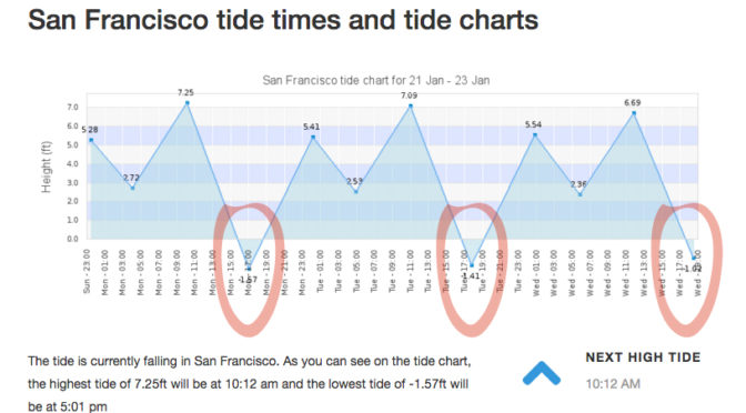
There is nothing like a full moon to uncover what lies beneath the surface of the earth. I’m not going to lie, I’ve been learning as I go about this phenomenon called ‘tides’ since I have been kayaking and was basically stuck in the mud trying to get to the shore walking my boat in mud up to my knees. It’s something I knew about but never really understood it’s wonder.  And then there’s King tides. Which is an even greater water level. Which I took notice when I was kayaking in Alameda and couldn’t get close to my kayak partner because the current was so great and I was tired from a long day of kayaking. So it’s not advisable to be kayaking or boating, or even being near the edge of the water because of sneaker waves. But at low tied it’s a great time to see what has been under the water all this time. During this King tide the water level reached 7+ feet at highest tide in the SF Bay Area. For me this mean there are a few ships including one from the 1800’s I have to go see at it’s lowest tide. This King tide will last just a few days.

Unfortunately the lowest tide had been at sunset, and with the clouds almost impossible to see, but I DID!  I was at Point San Pablo at 5pm ish and on the road looking into Point San Pablo Harbor and off to the left of the harbor you can see the shape of what appears to be a large wood ship. What is left is just the frame that look like a fence of just posts.
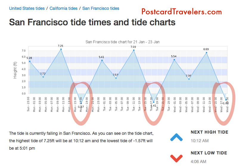
King Tides Week of January 21-23

Here are some important tips that will educate even just a hiker or walker along any Bay or shore in the world! No matter where you go. And if you are traveling, you are most likely planning on being near water! So be aware, knowledge is power.

Parking. With out looking at a tide chart, you can logically look at the ground and see where the water line is on low and high tide. Usually the water line is pretty apparent.  Know that if it is low tide and your car is far away from the water. It can possible be submerged when you get back! Or the road you came in will be submerged as well. Almost for sure when there is a King tide.

Kayaking and boating and being stuck in the mud. Have no fear. Know that every 6 hours the Tide changes direction. Before it dose it will sit for a hour before it makes it way back called a slack tide. Most the time you don’t know the tide is even moving. So it can creep up on you. Lets say you planned to get out of the water and there is 20 feet of mud. You can wait it out cut it will eventually fill up.


Wikipedia Ebb and Flow
“Ebb and flow (also called ebb and flood and flood drain) are two phases of the tide or any similar movement of water. The ebb is the outgoing phase, when the tide drains away from the shore; and the flow is the incoming phase when water rises again. The terms are also common in figurative use…” – Wikipedia

Slack tides

“Slack water, also known as ‘the stand of the tide’, is a short period in a body of tidal water when the water is completely unstressed, and there is no movement either way in the tidal stream, and which occurs before the direction of the tidal stream reverses…” – Wikipedia

More incite: When you see a boat in the mud tipped over, have no fear. It’s most likely the owner misjudged the tides and soon the water will be back to fill up.

Boater rules. It is boaters curtsy and I think law that you’re never supposed to pass by a boater in need of help. [article] You could save their life, even if at the moment they seam to be fine.

Currents. Currents are whats happening underneath. When you get near large objects like bridges, boulders, etc. The water rushes more and is stronger to get around those objects.  Think of the SF Bay as a big bottle of water with a  small neck (the golden Gate Bridge) that poor into another bottle of water and it takes 6 hours to pour on to the other bottle. As it pours back into the SF Bay it fills all the little bays as it goes back out to sea it’s sucks the water from the shore line leaving sometimes 4 to 20 feet of mud depending where you are at. This is world wide. If you don’t want to be stuck in the mud, plan on coming out of the water at high tide. However, you also want to think about the direction of the current. It’s a delicate balance of knowing the current. Sometimes, excuse my language but it can be a bitch going against the current! So there are 2 known factors tides and current. The wild card is weather / wind factor. You can go with a current but against the wind. And honestly I don’t know what is worse. And then there is light. Ya, you got it planned out on paper, but what about sunset? Will you be able to see when you get out? And if it’s cloudy or near mountains or cliffs you can loose hours of good light!  Whew, thats a lot to think about. But you should always think about it!! One time when I was in Zion National Park we didn’t start a hike until 3pm, I know, duh!! Not my fault. Anyway, even though we could see at the top of the mountain. Walking back it was in the straight up dark! The mountains basically had us in a crack in the ground. Luckily I was prepared and had a head lamp light in my arsenal of stuff. Petzel is a great bran. Always buy your adventure gear at REI, I recommend becoming a member worth the bucks. You’ll get it back in lots of lifetime savings!  They are our sponsor and affiliate because I love them!
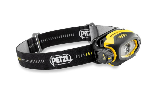
Headlamps
Petzl Headlamps


A cheaper and great option is this little head lamp that I clip on my hat. Best thing since sliced bread! I love it. I have two one for me and on for a adventure partner. They are usually never prepared. I always wear a baseball cap. If you don’t, it’s not the best option. For me, it is!
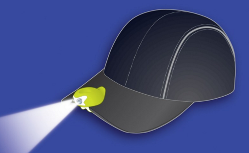
My Favorite Amphipod Swift-Clip Cap Light


I also have one of these clipped on my belt hiking belt. And life jacket. I think it’s great to have at all times. Not exactly a flash ligt but in a emergency it can help guide you hime. However I don’t know how water proof it is. Just don’t be cheap about these items!
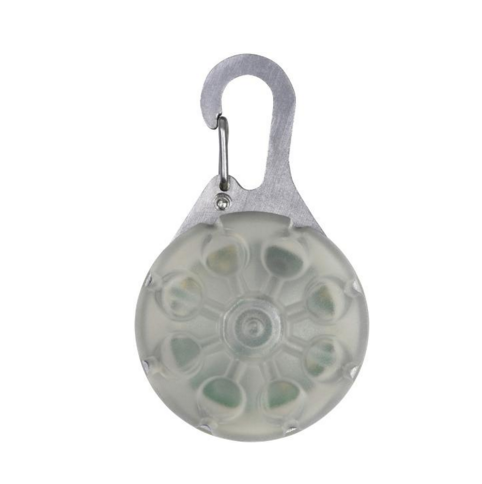
 

Favorite thins Nite Ize SpotLit LED Carabiner Light


Maps or better yet officially called “Charts” A NOAA chart will show you how deep the water is at it normal low level. It will also show ship wrecks the are submerged so boaters with engines don’t run into them.  For me it’s a place to explore and how I found may locations of shipwrecks. They are free on line. If your a boater / kayaker I recommend buying the one of the area you frequent. For me it’s like a treasure map!

[LINK to Charts]

I will up date this blog as I find my shipwrecks during the King Tides.

May Adventure Map. Zoom into Ocean Beach Area, Hunters point and Richmond bridge area on the Richmond side and Point San Pablo. There are layers at the top you can turn on more layers and turn off layers.


Have a great adventure, be safe by being wise.


Put this on your busket list:
Nobilis Restaurant
1900 Stenmark Dr
Richmond, CA 94801
Phone number (510) 233-3224

By Stacy Poulos Postcard Travelers

Postcard Travelers Adventure Magazine
Host: Photographer / Filmmaker Stacy Poulos

Author of Life In A Nutshell

**Blog: http://PostcardTravelers.com
**Fan: http://Facebook.com/postcardtravelersxoxo
**Instagram: http://Instagram.com/postcardtravelers
**Pinterest Bucket List: http://pinterest.com/PCTravelers
**Video Channel: http://youtube.com/user/PostcardTravelers
**Twitter: https://twitter.com/PCTravelers

Need a product or service reviewed? Send it to:

PostcardTravelers
Po Box 20608, Castro Valley, CA 94546

Have camera will travel.
©2017 Postcard Travelers
Sponsor REI goo.gl/thWgwA

Devils Hole; To Hell and Back; Las Trampas Regional Wilderness By Stacy Poulos

Devils Hole; To Hell and Back; Las Trampas Regional Wilderness   By Stacy Poulos
Devils Hole; To Hell and Back; Las Trampas Regional Wilderness By Stacy Poulos
Devils Hole; To Hell and Back; Las Trampas Regional Wilderness   By Stacy Poulos
Devils Hole; To Hell and Back; Las Trampas Regional Wilderness By Stacy Poulos
Devils Hole; To Hell and Back

Las Trampas Regional Wilderness

By Stacy Poulos

More photos: [Click] 

Here’s a 360 photo. Click on the upper right to expand. [Click here]

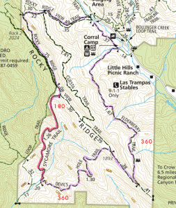
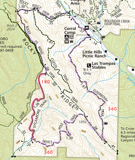
Ok Here’s the thing, I got my ass kicked yesterday. The good part about every mountain, is it hides the next mountain and valley you must walk through. So, when you think you have concord an extraordinary feat in your life, to walk the miles you have, you come to another clearing where you have an even longer and harder distance to go. Shit! I was thinking about an analogy of what I went through yesterday, when I was driving over the San Mateo bridge and seen a tiny distant light across the bay to my left thinking, that is where I’m going… in my car. Yesterday, it was on foot, times 10. That light was like the people ahead of me near the bend of the trail. Really!!?? ….that’s where were going! Again!!! Shit! I kept thinking, obviously I have no concept what these maps mean, or what 6.6 miles is in people feet walking. I was just proud as a graphic artist, I was able to highlight the proposed trail on my map. (I think my guide, who has the body of Jack LaLanne, also has no concept what a 4 in difficulty, means on a scale of 1 to 10 to out of shape people), like what 4 beers  is to someone 180 lbs, is a lot different to someone 110 lbs. I guess it’s all relative, and I really need to qualify the situation a little better, if I live. People who make up these numbers should consider the delusion of out of shape people, who think they can hike. He was just concerned that it was 94 degrees high noon heat in the thick of it. Humm. [Thats it! …in my own mind… You think only ‘heat’ is the issue here, as I pant, grasping my stomach wondering what Turkey Vultures gonna get me when I’m left behind.  As people drop off in the shade to bring there huffing down to a point of manageable blood pressure after a hiking some horrendous incline at a 500 feet incline back out of Devils Hole.] “Only 200 zig zag feet in elevation to go, he says” but look theres a shady tree up ahead.] Deeeevvvviiiils Holeeee, That! Should have been my first clue when I read the map. [“Oh good, Devils Hole sounds mysterious, this is going to be a great adventure. Wooo hooo, here we gooooo.”]  Now I know why they call it Devils Hole, sounds like fun, but to get there, and out of there, you will feel like you have gone to Hell and back.

Devils Hole; To Hell and Back; Las Trampas Regional Wilderness   By Stacy Poulos
Devils Hole; To Hell and Back; Las Trampas Regional Wilderness By Stacy Poulos

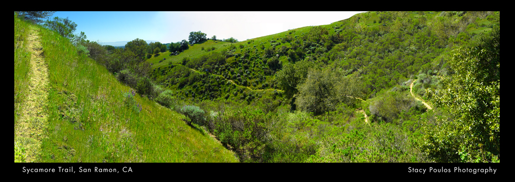
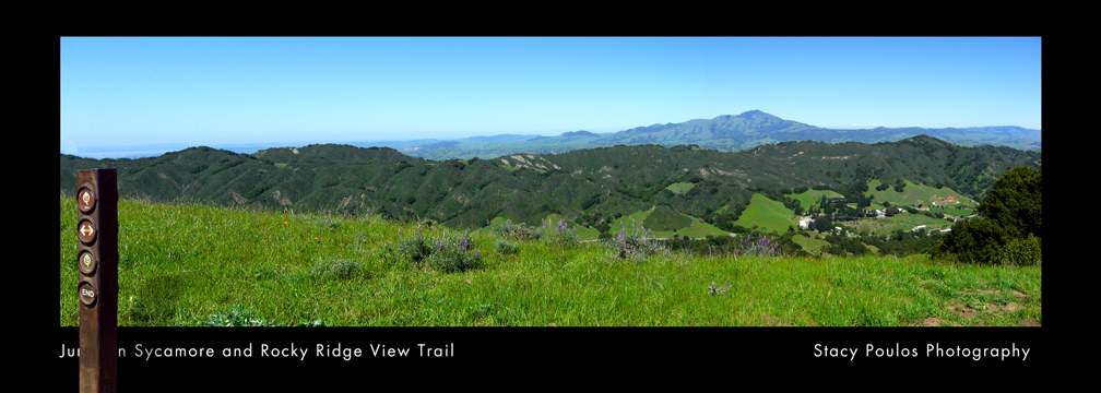
So, all kidding aside (not), it was; beautiful scene, after beautiful scene. Amazing this is in the heart of the East Bay surrounded by rural areas and city life. You couldn’t see any homes once you got to the other side, but a lake (San Leandro reservoir) with lots of green trees and brush, a few mountainy rocks and 60 miles in the distance you could see San Francisco smaller than a inch.

I chronicled my trip in photos, so when they found me dead underneath a poison oak plant, they would know how far and why I had past out. Besides our fall back group having fun plotting out how we were going to hold down the leader and kick his ass, if we lived to see the end, who now looks like a dot, on yet another ridge we must conquer. I thought to myself, self, thankfully America has the foresite to preserve these areas. And even though I’ll never see Devils Hole again, unless it’s on a post card, in my nightmares, or from a helicopter. I want to figure out how I can support State Parks more.  If we’re to stupid to not enjoy them, we should at least make sure they are their for those who do.

Devils Hole; To Hell and Back; Las Trampas Regional Wilderness   By Stacy Poulos
Devils Hole; To Hell and Back; Las Trampas Regional Wilderness By Stacy Poulos

If you’re an in shape experienced hiker, you may like this hike. Our leader is a great guy and super nice. Maybe a little delusional about his numbers. I’d go to this kind of hike at any point …for a mile and that would be pushing it. Unfortunately you have to go to Devils Hole, to get to ‘Sycamore trail’ which is the best of all the trails. It was the most interesting to see, but the most treacherous  elevation hike. It was under the most brush, which made the 94 degree weather not so bad for the hardest part.

360 At lunch in Devil’s Hole [click]

For some one like me, I would take a trip like this if it was a 4 day hike. Hike camp. Hike, camp. Not all in one shot. We started with 47 people, all grouped up for the first quarter mile. Then our group  spread out about a quarter mile apart in smaller groups. Me, taking up the tail with the fall back group, another couple who had a baby with them, and with another experienced woman hiker of this Trail with a old and slow dog. (My buddy). Who eventually split, before Devils Hole. (Our “Half Way point”). Obviously a wiser woman.  ..another clue what was to come.

Being a mother Bear instinct myself, I was concerned for the momma and the baby, since I was huffing and puffing and had all my limbs to break a fall, she had to care for her daughter with one arm to protect her. There were a lot of situations where we had the luxury of two arms to get through some sticky situations and her only one.

So what else can I say? 24 ounces of water is not enough. I was out of water, when I got out of Hell. Once out of Hell, I would have paid $20.00 for a bottle of Ice cold gatorade. Luckily I had to new fallback people that were generous and well equipped that shared theres.

Before, I froze 3 mini 4 oz. collapsible containers, to keep my sandwich cool till lunch, great idea, BUT I think I miss read that to, it was more like concentrate, yuck. I thought of many inventions along the way, like a hat fan you clip on the brim of a baseball hat that is solar powered facing your face. Miniature handy wipe bags you can reseal.

At first I think, ‘what are these people doing bringing ‘back packs’, were going for a ‘walk’. Then I was jealous of all the amenities they had. Like our leader had an inflatable seat cushion to sit on.  It was handy when we were in Hell lingering around having lunch, looking at Heaven. In light of wanting to sit along the hike, I thought an inflatable pair of shorts would be handy. Also the babies momma could have used a unit to keep her baby on her chest like she did, but not with such thick material and something to keep them cool and secure. One gal brought crackers and espresso beans to share, since I missed my espresso in the morning I indulged. She said she froze them so they wouldn’t melt. She’s not the only one who froze something, one man who supplied me with water after I ran out in Hell, froze his gatorade the night before. We ended up having more people join our fall back team who were welcomed with open arms. Especially with extra supplies!

 Devils Hole; To Hell and Back; Las Trampas Regional Wilderness   By Stacy Poulos
Devils Hole; To Hell and Back; Las Trampas Regional Wilderness By Stacy Poulos

And for the record, if your going down and not in the direction of your car, your gonna to have to go up. In our case, up, and up, and up and up! If your wondering what those skinny unmarked lines that connect in circles from large to small around the trail you are on, they are mountains, the smallest circle is the tip. So, in conclusion, when you see several small circles on your trail, they will be the mountains in your way you will have to hike on, down, up and around. “W” means water incase your from Europe and think “W” means Water Hole as in bathroom. Ironically what seamed to be a little trail of Heaven on our last stretch, a easy paved road that seam to go straight to the parking lot, was the hardest stretch. Because of the steep decline put a lot of awkward pressure on your knees and jams your toes to the tip of your shoes. Even though I knew none of the 47 people I started out with, it was probably better that my friends bailed on me, they would have kicked my ass. I’m sure in a few days I’ll think I had fun, and forget I was paralyzed from the pain the next day and walked like a penguin with a stick up my butt for a week.

Devils Hole; To Hell and Back; Las Trampas Regional Wilderness   By Stacy Poulos
Devils Hole; To Hell and Back; Las Trampas Regional Wilderness By Stacy Poulos

But you know, I wanted my ass kicked really, I deserved it for letting myself get so out of shape in so many ways, when I’m a born athlete. I’m not going to be my true potential God intended me to be, if I let myself go so much as I had. I’m just not someone who can go to a gym and breathe the air of others sweat, focused on just the workout. If God intended us to keep our bodies in shape at a gym,he wouldn’t have created the great out doors. So in a way, my leader was a Saint that took us in and out of Hell. The Hell we live for not getting out and seeing the world and respecting our bodies. Days like these, you think about who your are, and how you pollute yourself with unnecessary crap. (Maybe 6.6 was a little dramatic for my first day out) rubbing the skin off the back of my feet, jamming my toes and knees. Straining every muscle I have, especially the one between my ears trying to find a way out, a kebab I can jump on to kebab down the hill instead of walking it. A helicopter to pick me up and take me home to my mommy.

“All ails fails, read the directions” is our family motto. As I go back to review the website to see where I may have missed something, I read the the leaders profile for the 1st time.  He says: “My experience level with hiking is very advanced – numerous hikes more than 12 miles, many with many, many thousands of feet of elevation change. …and am always pushing my hiking further – literally. That being said, I love to introduce new people to the sport, and can enjoy anything from very mild to ugh! level hikes. Between hiking, treadmill, and trail running my goal is to get in at least 20 miles a week of cardio, shooting for 25+ though!..” Well. Sigh! There you go. I followed a psycho hiker. Thank you!! I now have a Callus on my foot named after you.

Then I read The Sierra Clubs description “About this Trail… This is a 6.3 mile long loop hike to Devil’s Hole over Rocky Ridge. Enjoy lung-busting climbs to rocky ridges offering breathtaking 360 degree views of Ramage Peak at 1401 feet, Mt. Diablo at 3849 feet, the Ohlone Ridge out beyond Livermore, and Grizzly and Volvon Peaks dominating the Berkeley Hills horizon. Enjoy the wild life, eagles, hawks, and buzzing buzzards (turkey vultures, cousin to the more glamorous California Condor) patrolling the deep blue skies, bobcats and mountain lions skulking about or sleeping nearby in the sandstone cave outcroppings.” Blah, blah, blah.. “Change in Elevation: 1200, Elevation at trailhead: 1080, Highest Elevation: 1960 (Why my knees and butt-tox hurt) Lowest Elevation: 1080” .. eeeexxxxaaaccctttly!!

Devils Hole; To Hell and Back; Las Trampas Regional Wilderness   By Stacy Poulos
Devils Hole; To Hell and Back; Las Trampas Regional Wilderness By Stacy Poulos

Thank you my fearless leader for taking the brunt of our commiserating I loved every minute of it. I think all the new comers miss judged the ‘4’ in difficulty and probably didn’t read your personal profile. Then again they were probably like me, wanted the inspiration of a group to go on a journey. No matter how difficult.  If I go with this group again, it will be on a ‘1’ difficulty for a mile. His next trip is to be a 10 mile hike… Black Diamond Mines Regional Preserve… I’m out! ‘But there’s a cave… ‘nope, I’m out!

More photos: [Click] 

PostcardTraveler Adventure Magazine
Host: Photographer / Filmmaker Stacy Poulos
Author of ‘Life In A Nutshell’
 
>>Pinterest Bucket List: https://www.pinterest.com/pctravelers/
 
Need a product or service reviewed?
Send it to: 
PostcardTravelers
Po Box 20608, Castro Valley, CA 94546
Have camera will travel. 
©2017 Postcard Travelers