Pirates, shipwrecks, and Ghosts Adventure Map By Stacy Poulos PostcardTravelers.com
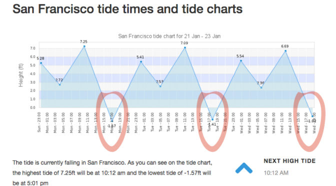
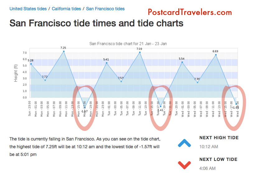
There is nothing like a full moon to uncover what lies beneath the surface of the earth. I’m not going to lie, I’ve been learning as I go about this phenomenon called ‘tides’ since I have been kayaking and was basically stuck in the mud trying to get to the shore walking my boat in mud up to my knees. It’s something I knew about but never really understood it’s wonder. And then there’s King tides. Which is an even greater water level. Which I took notice when I was kayaking in Alameda and couldn’t get close to my kayak partner because the current was so great and I was tired from a long day of kayaking. So it’s not advisable to be kayaking or boating, or even being near the edge of the water because of sneaker waves. But at low tied it’s a great time to see what has been under the water all this time. During this King tide the water level reached 7+ feet at highest tide in the SF Bay Area. For me this mean there are a few ships including one from the 1800’s I have to go see at it’s lowest tide. This King tide will last just a few days.
Unfortunately the lowest tide had been at sunset, and with the clouds almost impossible to see, but I DID! I was at Point San Pablo at 5pm ish and on the road looking into Point San Pablo Harbor and off to the left of the harbor you can see the shape of what appears to be a large wood ship. What is left is just the frame that look like a fence of just posts.
King Tides Week of January 21-23
Here are some important tips that will educate even just a hiker or walker along any Bay or shore in the world! No matter where you go. And if you are traveling, you are most likely planning on being near water! So be aware, knowledge is power.
Parking. With out looking at a tide chart, you can logically look at the ground and see where the water line is on low and high tide. Usually the water line is pretty apparent. Know that if it is low tide and your car is far away from the water. It can possible be submerged when you get back! Or the road you came in will be submerged as well. Almost for sure when there is a King tide.
Kayaking and boating and being stuck in the mud. Have no fear. Know that every 6 hours the Tide changes direction. Before it dose it will sit for a hour before it makes it way back called a slack tide. Most the time you don’t know the tide is even moving. So it can creep up on you. Lets say you planned to get out of the water and there is 20 feet of mud. You can wait it out cut it will eventually fill up.
Wikipedia Ebb and Flow
“Ebb and flow (also called ebb and flood and flood drain) are two phases of the tide or any similar movement of water. The ebb is the outgoing phase, when the tide drains away from the shore; and the flow is the incoming phase when water rises again. The terms are also common in figurative use…” – Wikipedia
“Slack water, also known as ‘the stand of the tide’, is a short period in a body of tidal water when the water is completely unstressed, and there is no movement either way in the tidal stream, and which occurs before the direction of the tidal stream reverses…” – Wikipedia
More incite: When you see a boat in the mud tipped over, have no fear. It’s most likely the owner misjudged the tides and soon the water will be back to fill up.
Boater rules. It is boaters curtsy and I think law that you’re never supposed to pass by a boater in need of help. [article] You could save their life, even if at the moment they seam to be fine.
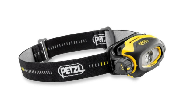
Currents. Currents are whats happening underneath. When you get near large objects like bridges, boulders, etc. The water rushes more and is stronger to get around those objects. Think of the SF Bay as a big bottle of water with a small neck (the golden Gate Bridge) that poor into another bottle of water and it takes 6 hours to pour on to the other bottle. As it pours back into the SF Bay it fills all the little bays as it goes back out to sea it’s sucks the water from the shore line leaving sometimes 4 to 20 feet of mud depending where you are at. This is world wide. If you don’t want to be stuck in the mud, plan on coming out of the water at high tide. However, you also want to think about the direction of the current. It’s a delicate balance of knowing the current. Sometimes, excuse my language but it can be a bitch going against the current! So there are 2 known factors tides and current. The wild card is weather / wind factor. You can go with a current but against the wind. And honestly I don’t know what is worse. And then there is light. Ya, you got it planned out on paper, but what about sunset? Will you be able to see when you get out? And if it’s cloudy or near mountains or cliffs you can loose hours of good light! Whew, thats a lot to think about. But you should always think about it!! One time when I was in Zion National Park we didn’t start a hike until 3pm, I know, duh!! Not my fault. Anyway, even though we could see at the top of the mountain. Walking back it was in the straight up dark! The mountains basically had us in a crack in the ground. Luckily I was prepared and had a head lamp light in my arsenal of stuff. Petzel is a great bran. Always buy your adventure gear at REI, I recommend becoming a member worth the bucks. You’ll get it back in lots of lifetime savings! They are our sponsor and affiliate because I love them!
Petzl Headlamps
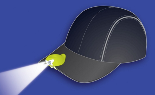
A cheaper and great option is this little head lamp that I clip on my hat. Best thing since sliced bread! I love it. I have two one for me and on for a adventure partner. They are usually never prepared. I always wear a baseball cap. If you don’t, it’s not the best option. For me, it is!
My Favorite Amphipod Swift-Clip Cap Light
I also have one of these clipped on my belt hiking belt. And life jacket. I think it’s great to have at all times. Not exactly a flash ligt but in a emergency it can help guide you hime. However I don’t know how water proof it is. Just don’t be cheap about these items!
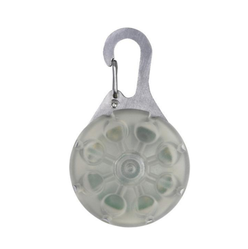
Favorite thins Nite Ize SpotLit LED Carabiner Light
Maps or better yet officially called “Charts” A NOAA chart will show you how deep the water is at it normal low level. It will also show ship wrecks the are submerged so boaters with engines don’t run into them. For me it’s a place to explore and how I found may locations of shipwrecks. They are free on line. If your a boater / kayaker I recommend buying the one of the area you frequent. For me it’s like a treasure map!
I will up date this blog as I find my shipwrecks during the King Tides.
May Adventure Map. Zoom into Ocean Beach Area, Hunters point and Richmond bridge area on the Richmond side and Point San Pablo. There are layers at the top you can turn on more layers and turn off layers.
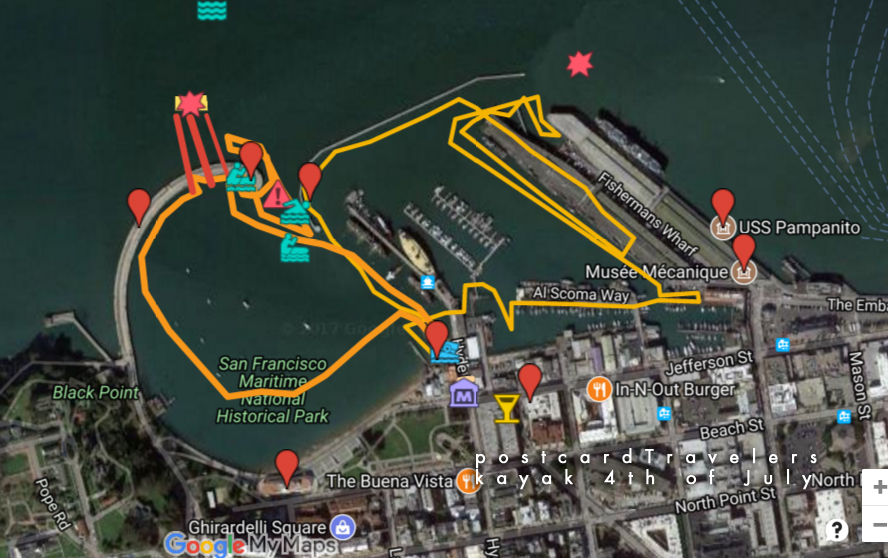
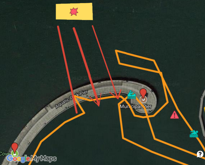
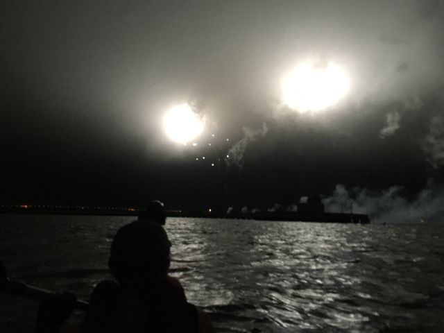
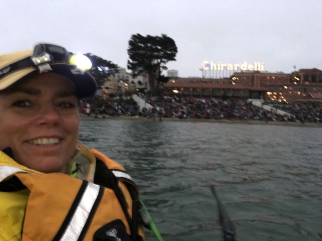
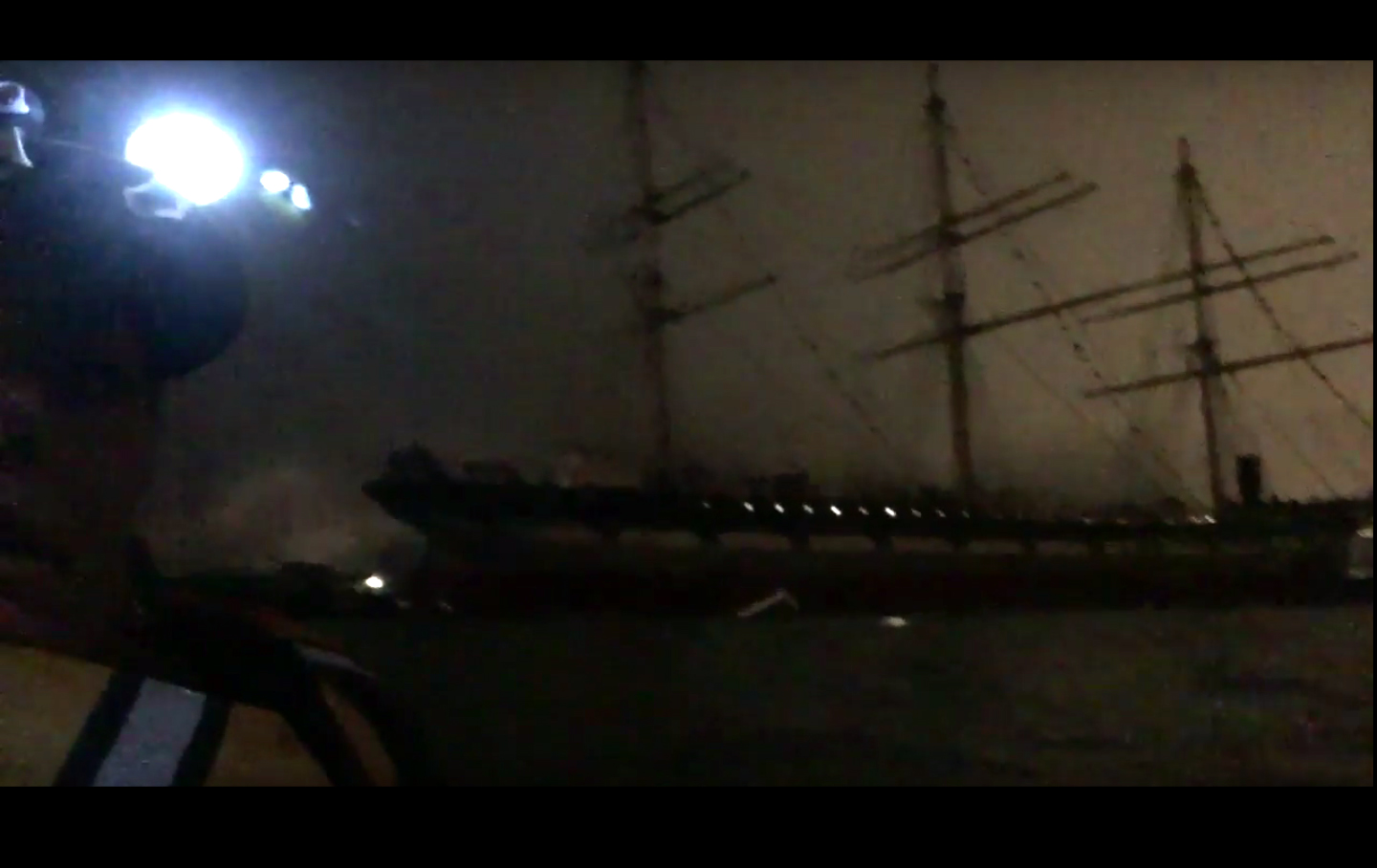
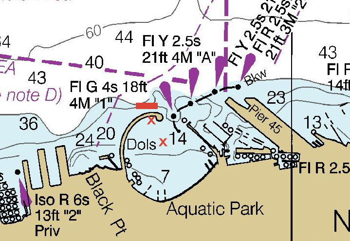
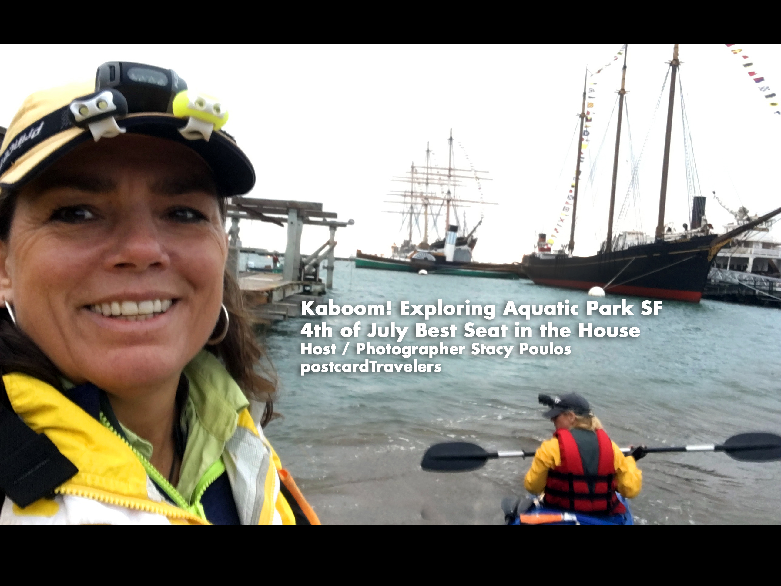
Kaboom! I can take this off my bucket list, being directly under the projection of the fireworks at the Aquatic Park Historic District pier! We put-in our boat and launched at Hyde Street Pier in San Francisco, California. Hovering under the pier A little too close for comfort, until the fireworks unsuspectedly started. The current kept making us drift quickly away so we hovered under the pier. We even had all our lights off to save batteries, so we were in the dark. The first echoing Kaboom explosionsunder the pier were un-describable. Enough to rattle your nerves! I was deeper under the pier being in the back of the boat looking out at Ghirardelli Square. *In this video I said ‘last time I got in trouble’. It was because I got too close to the Historic boats. There were no signs that I could see at the time. It is kind of roped off with buoys. This time we stayed further away out side the line. One way or another, I recommend this spot. During the day there is a live concert on shore. We had a back stage pass, a nice little additive to the day. The yellow box with the star is where the fireworks barge is. The Teal Green boater is where we hovered until the fireworks started.
fireworks projection san francisco Aquatic Park
However, I don’t recommend right there. Much too close. Instead bring a anchor at least 20 feet long and hover at a safe distance like we are in the photo below. To the left and center of the park here we are look at the Municipal Pier a posed to being under it!
Live Concert at Ghirardelli Square 4th of July
So, planning for next year. I recommend going here. Be more prepared. I do own a kayak anchor. When I looked at the Coast Guard Map it said it was around 7-14 feet deep in the area but there is only one marker and I didn’t think my anchor was that long. Besides it being a pain to add more weight. Next time I will bring one for sure! If your planning on hovering in the ocean, there is always a current. Anyway, below is a live interactive google map with all my notes for 4th of July over the years in the SF Bay. If you click on any icon, it will zoom into that note. When you click on ‘Aquatic Park Historic District‘ And look at the orange line that was our path in 2017. To the upper left of the map are my notes, that little box’ie icon on the upper top left corner opens the notes, click on anything at it will bring you to the spot on the map. Bottom right is the + and – zoom button. You can then close the notes with the left arrow it to get the notes out of the way. I also have a layer of land notes, where I intend to go for a city hike and check out the same area on land someday.
Aquatic Park Historic District pier Ghirardelli Square 4th of July
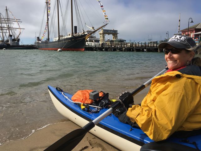
Launching on Hyde Street Pier AquaticPark. I’m not sure you can launch out of the museum. Since the public beach was full of people we couldn’t go their.
History of the 4th –
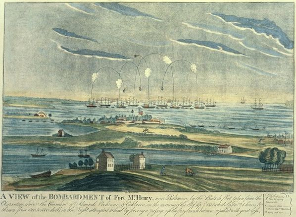
I think this is one of the safer and best spots in the San Francisco bay to view the fireworks from land or water. If you know the History of the 4th, or Independence Day and the inspiration to our National Anthem, you would know the 4th of July is meant to replicate what Francis Scott Key seen on that fateful day in 1812. He was a British lawyer on the French Ship; HMS Tonnant negotiating a British prisoner exchange were he was to negotiate the release of prisoners, during the Battle of Baltimore at Fort McHenry. (The only other place that can possibly top this spot). Key learned too much about the French’s attack on the British, so they kept him a prisoner as well. So all during that night Key witnessed the fireworks in the bay of Fort McHenry. In the morning when the fireworks stopped, and lack of communication the only way to know who won the battle was the American flag still standing. He wrote a poem “Defence of Fort M’Henry”, that later became the lyrics to ‘The Star Spangled Banner’.
So why is this the best spot? First of all, the Maritime National Historical Park is situated inside Aquatic Park San Francisco… in the water! There are period ships to set the perfect scenery of what the bay may have looked like. The ships are much younger in the park; like the Balclutha 1886 and the C. A. Thayer 1895 but look very similar. Add a dark sky with a silhouette of the old ships sails from the 1800’s lit up by fireworks, well you’ll get the picture and full effect. A lot of people don’t know this History, so why do I? I wrote a book report in the 4th or 5th grade about it. I found it fascinating that people were so affected and heart felt over a song, it inspired me to want to write music. So now you know. Now let’s let Key set the story and imagine the background.
Oh say, can you see, by the dawn’s early light, What so proudly we hailed at the twilight’s last gleaming, Whose broad stripes and bright stars, through the perilous fight, O’er the ramparts we watched, were so gallantly streaming? And the rockets’ red glare, the bombs bursting in air, Gave proof thru the night that our flag was still there. Oh say, does that star-spangled banner yet wave O’er the land of the free and the home of the brave?
SanFrancisco Maritime National Historical Park Fireworks Francis Scott Key, 1779–1843
So we won. And every year we celebrate this day in a grand way.
Reason 2, why it’s the best place to kayak on the 4th? The park is protected by a breakwater pier. However, that doesn’t mean there aren’t strong currents, but it’s a protected area and larger boats can only go 5 mph. There are actually crazy swimmers swimming at night. There are police and coastguards near by. Of course if you don’t have a walkie talkie that wont do you any good. So it is most watched by land and sea.
Next good reason, the fireworks barge is directly on the other side of the pier and they project the firework into the park. Giving the people on land and sea one hell of a show! Wow!! We hovered under the pier until the fireworks started because the current was so strong it kept making us struggle to stay in one spot. On land you can walk and board the ships.
The depth in the park looks to be 7 to 14 feet deep. Of course I wouldn’t recommend where I was, the first fireworks rattled me to the core. Being under the pier echoed the effect in such away that you felt you were in a war being bombed. Not sure your supposed to be under there but we needed to be protected by the current. Eventually we let loose and drifted to the center of the park facing the fireworks and current. It was foggy as SF is, but it also had a unique effect in it’s self.
Dolphin Swim & Boat Club and South End Rowing Club
We Put-in at Hyde Street Park. I’m not gonna lie, I’m not sure your supposed to. I heard there was a public beach launch to the left of the photo but it was all blocked for pedestrians to view the show on shore. Since we got out next door to the rowing and dolphin club, I assume they assumed we were with them. Frankly it’s not fair there aren’t more safe put in areas for the public to launch. So you might want to try to arrange something or find out the real rules. We parked our car in the red zone on Hyde street, dropped the boat off onto the side walk, my friend parked the truck while I waited. We communicated through walkie takies, which I highly recommend getting water proof ones even if you don’t think you need them. You don’t want to kill your phone batteries trying to communicate and it’s a pain other wise. I will list my personal favorite things kayaking. Eventually we walked the kayak through the crowded street.
So, the park is not that big to explore a whole day, and if your going out side the park it should be done in much better conditions. You can putt around the park and see the ships below, just don’t get too close or they get mad. To the right / east, are docks you can explore. You can go in a area all the crab fishermen dock their boats. There is a lot of untold History in them, some barely afloat. Also before you get in the water you can actually go on these Historic ships for a small fee that supports our wonderful parks.
It was next to the Dolphin Swim & Boat Club and South End Rowing Club. You might want get involved with them to launch your kayak. We technically just walked through the Hyde Street gate and put our boat in. However the gate closes at 5pm, so you have to be out by then, or the gate is locked. You can technically still get out from inside, but not go back in, should you leave something behind. It’s a beach launch and even though it’s a protected area, there is a strong current when it comes time. How ever it’s protected and the current isn’t as strong as out side the park. It’s cool because you kayak next to old ships. Perfect setting for 4th of July. We hovered under the pier until it came time for the fire works. But be aware, even at 9pm at night there are crazy swimmers. We had the best seat in the house, with a back stage pass to a concert and being literally under the projection of the fireworks! Here’s a important notation it’s a beach launch, pretty mild. You go through the gates of the Museum and the gates close at 5pm. Most the people who work at the Museum are volunteers over 90, kidding. I don’t think they care.
However you can still get out because the gate is only locked for people getting in. So if your out in the Bay and need a emergency out, here it is. There is a public restroom.
To take a rest, we ended up landing at the Dolphin Swim & Boat Club. The girl sitting on the beach was really nice and helped pull us ashore until she realized we weren’t members cuz we asked dumb questions. Then her face turned unfriendly like we were on her property and said they don’t take to kindly to non-members. So we went next door, and went out the Row Club doors to the street. Much more friendly group of people. They promised they would let us back in to get to our boat.
We just wanted out of the water to rest. We just weren’t sure where to go, so we can come back to our boat. I just think it’s pure BS. 4th of July, land of the ‘free’ BS. Land of we own this, get the f’ off. When it comes to boating it’s dangerous to send boaters back out that need to rest. Or set their lights or get out of rough waters. We had struggled for a long time against the currents and wind, we needed to rest. I’ve got nothin’ for people that don’t help, sorry I disturbed your cozy picnic. I mean we are loaded down to kayak, do we look like we want to stay here? All in, all. There were only 4 kayakers besides us, anyone who really kayaks wouldn’t go out in, apparently, gusting winds which I wish they would say MPH, which is 16.1 to 19.6 MPH. Gusting means ‘gusting’ temporary burst of wind. Ok got it! Ya, so I’m learning as I go. Anyway, take that off my bucket list.
Old Fishing Boat Fisherman’s Warf SF Stacy Poulos Photography
Anyway, once parked we went across the street to the fancy Blue Mermaid Restaurant. I looked like a Uni-bomber with my kayak vest still on, walkie talkie, pilot knife. I had coffee while my friend had oysters and beer. Absolutely beautiful restaurant. I must go back. Anyway, all in all it was such a great evening. After the hair raising fireworks, Instead of leaving immediately, we loaded up the car with the boat, parked then went to a bar Jacks Cannery Bar for a night cap to let all the traffic go away. Sucks having to drink expensive beer (cash only) out of a plastic cup, when you just risked your life, I don’t know how many times… welcome back to land. But there was a mixed group of out of town’ers fun to chat with.
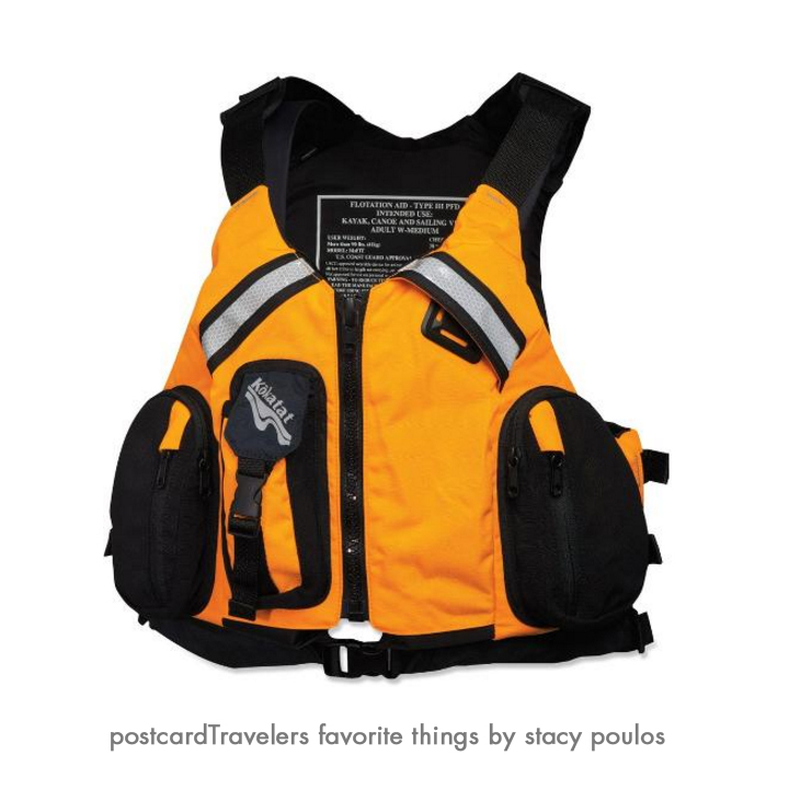
Below I listed some of my favorite things kayaking.
#1 My Kokatat MsFIT Tour PFD – Women’s Life vest.
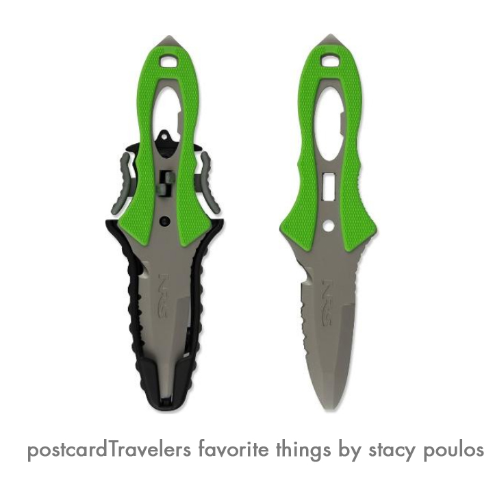
I love the walkie talkie pocket and the front stretch mesh pockets to stow essentials. The pocket are not water proof. But when I do put things in the pockets, they are in plastic in need be. The deep-cut neck and armholes maximize range of motion for my arms, there is a difference! I used to kayak with a ‘water ski jacket’ and it gave me rub burns under my arms. Your life vest is –your LIFE Vest! It’s a investment. Having things on your body and not hanging from your neck it super important. If you capsize you have less to get hung up on. Chapsitck and sunscreen and cell phone is in the pocket! However, getting back in the boat you have the pockets to contend with. Kokatat is a great brand, when I went to The Travel Show, a pro Kayker had one and she gave me a personal tour of her’s and she swore by it. I had my eye on it the first day I seen one. They are all very adjustable in size. I have a Large. You can say I’m smitten by mine. It also has a ‘Strobe lash tab’ I guess thats what they call it. Anyway, you can attach other things to it, for me I have my Rambo ‘NRS Pilot Knife’ which I love. There is Reflective tape on the back and chest. You never know when you will be out at night fall.
I will get more into products I love in a dedicated blog
Kokatat MsFIT Tour PFD Women pro favorite My NRS Pilot River Knife (Rambo) knife is always ready for action. It’s 3 inch stainless-steel blade with blunt safety tip has both smooth and serrated cutting edges; matte finish with a are hole in the handle that serves as a valve wrench for an oxygen tank a bottle opener is built into the handle. Comes in handy for many uses.
My NRS Pilot River Knife (Rambo) knife is always ready for action. It’s 3 inch stainless-steel blade with blunt safety tip has both smooth and serrated cutting edges; matte finish with a are hole in the handle that serves as a valve wrench for an oxygen tank a bottle opener is built into the handle. Comes in handy for many uses.
Motorola MS350R 35-Mile Talkabout Waterproof 2-Way Radio (Pair)
This is one of my favorite products. You think, everyone has a cell phone why not just call? You don’t want to ware out your cell phone communicating out on the road, trail or water. I use them everywhere! Hiking, kayaking. Used them in Europe to talk to my friends. Hands down best buy. They have a charging case so you just place them in the cradle after a long day. My mom got me mine for my birthday. You don’t want to dial and wait to ring, you want to send your message.
Ad a whistle to your vests, (super important) and your good to go! The whistle replaces a horn on a boat. I’ve actually been hit by a big boat, not dead on but swiped the side of my kayak. Having a whistle can help you let them know you are their since we sit so low in the water.