Tag Archives: Shipwreck San Pablo

King Tides equal shipwrecks and treasure hunting!

Pirates, shipwrecks, and Ghosts Adventure Map By Stacy Poulos PostcardTravelers.com

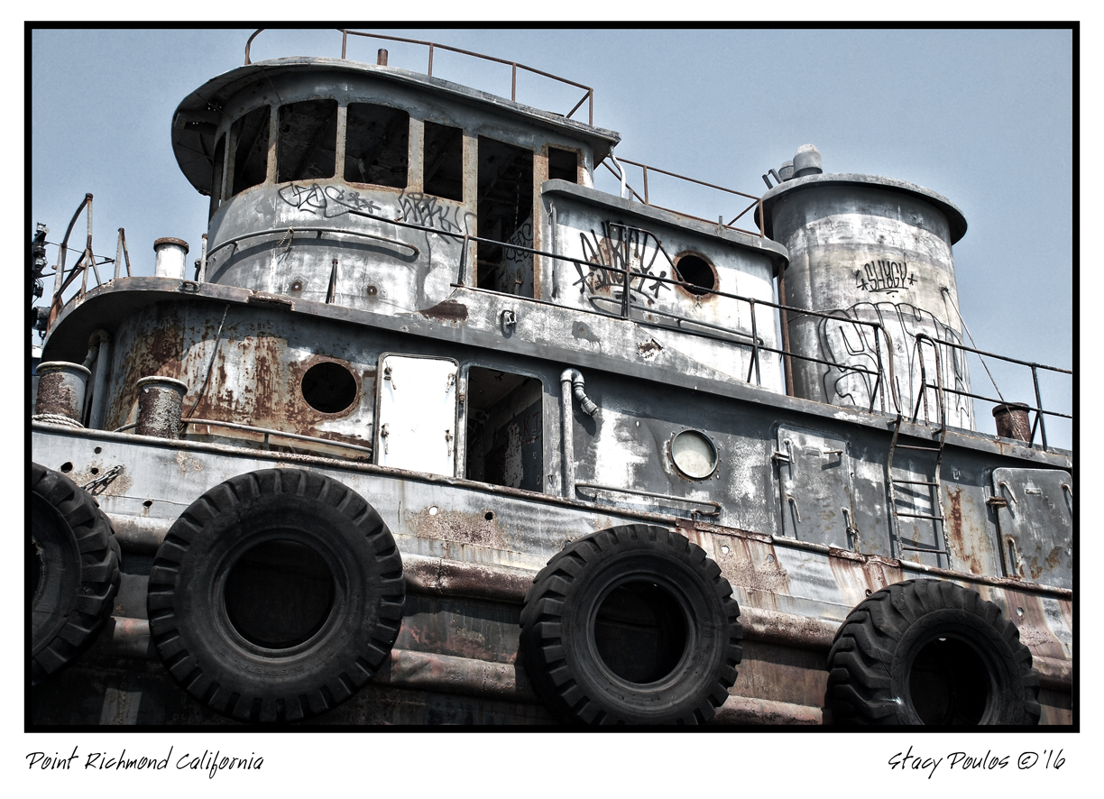
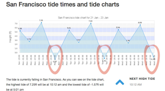
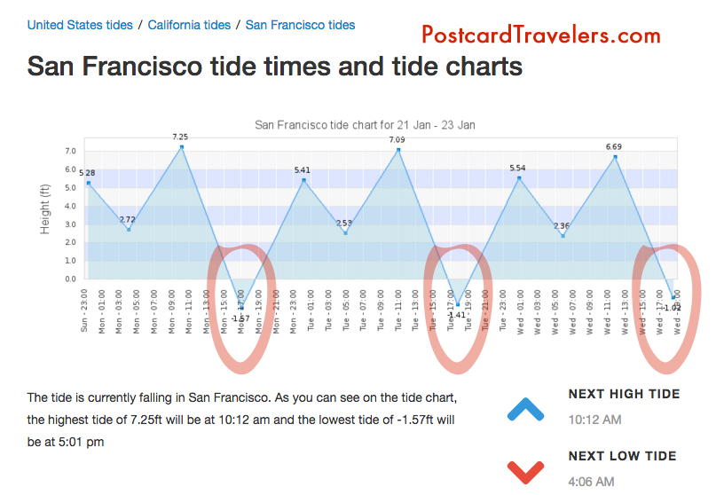
There is nothing like a full moon to uncover what lies beneath the surface of the earth. I’m not going to lie, I’ve been learning as I go about this phenomenon called ‘tides’ since I have been kayaking and was basically stuck in the mud trying to get to the shore walking my boat in mud up to my knees. It’s something I knew about but never really understood it’s wonder.  And then there’s King tides. Which is an even greater water level. Which I took notice when I was kayaking in Alameda and couldn’t get close to my kayak partner because the current was so great and I was tired from a long day of kayaking. So it’s not advisable to be kayaking or boating, or even being near the edge of the water because of sneaker waves. But at low tied it’s a great time to see what has been under the water all this time. During this King tide the water level reached 7+ feet at highest tide in the SF Bay Area. For me this mean there are a few ships including one from the 1800’s I have to go see at it’s lowest tide. This King tide will last just a few days.

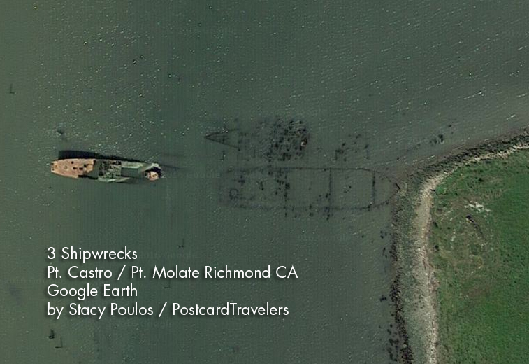
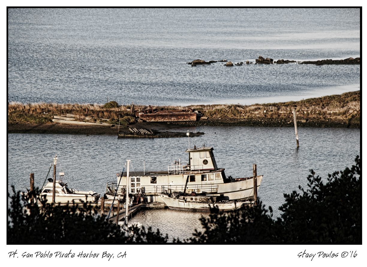
Unfortunately the lowest tide had been at sunset, and with the clouds almost impossible to see, but I DID!  I was at Point San Pablo at 5pm ish and on the road looking into Point San Pablo Harbor and off to the left of the harbor you can see the shape of what appears to be a large wood ship. What is left is just the frame that look like a fence of just posts.

King Tides Week of January 21-23

Here are some important tips that will educate even just a hiker or walker along any Bay or shore in the world! No matter where you go. And if you are traveling, you are most likely planning on being near water! So be aware, knowledge is power.

Parking. With out looking at a tide chart, you can logically look at the ground and see where the water line is on low and high tide. Usually the water line is pretty apparent.  Know that if it is low tide and your car is far away from the water. It can possible be submerged when you get back! Or the road you came in will be submerged as well. Almost for sure when there is a King tide.

Kayaking and boating and being stuck in the mud. Have no fear. Know that every 6 hours the Tide changes direction. Before it dose it will sit for a hour before it makes it way back called a slack tide. Most the time you don’t know the tide is even moving. So it can creep up on you. Lets say you planned to get out of the water and there is 20 feet of mud. You can wait it out cut it will eventually fill up.


Wikipedia Ebb and Flow
“Ebb and flow (also called ebb and flood and flood drain) are two phases of the tide or any similar movement of water. The ebb is the outgoing phase, when the tide drains away from the shore; and the flow is the incoming phase when water rises again. The terms are also common in figurative use…” – Wikipedia

Slack tides

“Slack water, also known as ‘the stand of the tide’, is a short period in a body of tidal water when the water is completely unstressed, and there is no movement either way in the tidal stream, and which occurs before the direction of the tidal stream reverses…” – Wikipedia

More incite: When you see a boat in the mud tipped over, have no fear. It’s most likely the owner misjudged the tides and soon the water will be back to fill up.

Boater rules. It is boaters curtsy and I think law that you’re never supposed to pass by a boater in need of help. [article] You could save their life, even if at the moment they seam to be fine.

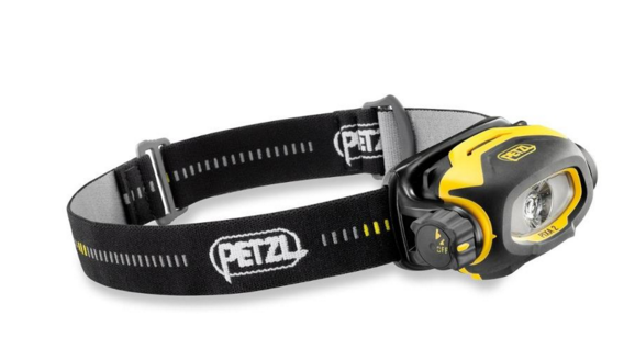
Currents. Currents are whats happening underneath. When you get near large objects like bridges, boulders, etc. The water rushes more and is stronger to get around those objects.  Think of the SF Bay as a big bottle of water with a  small neck (the golden Gate Bridge) that poor into another bottle of water and it takes 6 hours to pour on to the other bottle. As it pours back into the SF Bay it fills all the little bays as it goes back out to sea it’s sucks the water from the shore line leaving sometimes 4 to 20 feet of mud depending where you are at. This is world wide. If you don’t want to be stuck in the mud, plan on coming out of the water at high tide. However, you also want to think about the direction of the current. It’s a delicate balance of knowing the current. Sometimes, excuse my language but it can be a bitch going against the current! So there are 2 known factors tides and current. The wild card is weather / wind factor. You can go with a current but against the wind. And honestly I don’t know what is worse. And then there is light. Ya, you got it planned out on paper, but what about sunset? Will you be able to see when you get out? And if it’s cloudy or near mountains or cliffs you can loose hours of good light!  Whew, thats a lot to think about. But you should always think about it!! One time when I was in Zion National Park we didn’t start a hike until 3pm, I know, duh!! Not my fault. Anyway, even though we could see at the top of the mountain. Walking back it was in the straight up dark! The mountains basically had us in a crack in the ground. Luckily I was prepared and had a head lamp light in my arsenal of stuff. Petzel is a great bran. Always buy your adventure gear at REI, I recommend becoming a member worth the bucks. You’ll get it back in lots of lifetime savings!  They are our sponsor and affiliate because I love them!

Headlamps
Petzl Headlamps


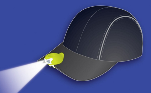
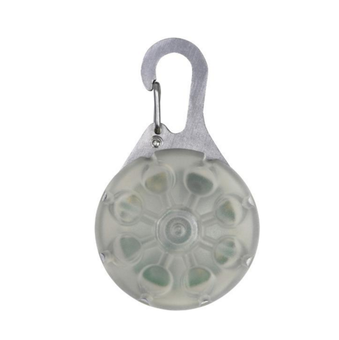
A cheaper and great option is this little head lamp that I clip on my hat. Best thing since sliced bread! I love it. I have two one for me and on for a adventure partner. They are usually never prepared. I always wear a baseball cap. If you don’t, it’s not the best option. For me, it is!

My Favorite Amphipod Swift-Clip Cap Light


I also have one of these clipped on my belt hiking belt. And life jacket. I think it’s great to have at all times. Not exactly a flash ligt but in a emergency it can help guide you hime. However I don’t know how water proof it is. Just don’t be cheap about these items!


Favorite thins Nite Ize SpotLit LED Carabiner Light


Maps or better yet officially called “Charts” A NOAA chart will show you how deep the water is at it normal low level. It will also show ship wrecks the are submerged so boaters with engines don’t run into them.  For me it’s a place to explore and how I found may locations of shipwrecks. They are free on line. If your a boater / kayaker I recommend buying the one of the area you frequent. For me it’s like a treasure map!

[LINK to Charts]

I will up date this blog as I find my shipwrecks during the King Tides.

May Adventure Map. Zoom into Ocean Beach Area, Hunters point and Richmond bridge area on the Richmond side and Point San Pablo. There are layers at the top you can turn on more layers and turn off layers.


Have a great adventure, be safe by being wise.


Put this on your busket list:
Nobilis Restaurant
1900 Stenmark Dr
Richmond, CA 94801
Phone number (510) 233-3224

By Stacy Poulos Postcard Travelers

Postcard Travelers Adventure Magazine
Host: Photographer / Filmmaker Stacy Poulos

Author of Life In A Nutshell

**Blog: http://PostcardTravelers.com
**Fan: http://Facebook.com/postcardtravelersxoxo
**Instagram: http://Instagram.com/postcardtravelers
**Pinterest Bucket List: http://pinterest.com/PCTravelers
**Video Channel: http://youtube.com/user/PostcardTravelers
**Twitter: https://twitter.com/PCTravelers

Need a product or service reviewed? Send it to:

PostcardTravelers
Po Box 20608, Castro Valley, CA 94546

Have camera will travel.
©2017 Postcard Travelers
Sponsor REI goo.gl/thWgwA

Point Richmond California Adventures; Shipwrecks to Rosie The Riveter to Boasting The Worlds Largest Winery

By Stacy Poulos PostcardTravelers

Wineheaven

I’m always astonished how much rich History, or HerStory, there is right under our noses in the San Francisco Bay Area. I explored the waterfront area of Richmond by land and sea in search of what was once the largest Winery in the world when the California Wine Association moved from San Francisco to Point Molate Richmond after the San Francisco Earthquake in 1906. It remained the title of “World’s largest winery” for 12 years!! (1907–1919). Until prohibition crushed it’s demise and was shut down in 1919. Really, THE largest?  Over Italy and France? Yep, it’s true. Now it’s an abandoned ghost town once called “Winehaven California” (It is in the U.S. National Register of Historic Places) and it’s castle remains in tact north of the Point Molate Richmond. Stenmark Drive is the last exit before you get on the Richmond Bridge and it is littered with a extraordinary and riveting California History.

#richmondcalifornia #californiahistory #explore #kayak #hike #adventurelife #postcardtravelers #favoritethings #favoriteplaces #bayarea #bayareahistory

REI goo.gl/thWgwA

Great things for any adventure @ REI Co-Op
The largest Wine producer in the world for 12 years.

If you walk on Pt. Molate Park Beach facing the water Winehaven would be to your right, around the corner less than a mile away, you can’t walk to it on the beach, but you can see it. If continue to drive on Stenmark Dr you can see the backside through the fence from the road. There is a bit of a battle to what they are going to do with the area. In my humble opinion, it is rare to be able to boast the ‘largest in the world’ of anything, let alone the most prestigious commodity of wine! So. I say restore the castle and keep boasting! But there’s more.

Winehaven Pont Molante 1907-1919

Winehaven 2036-2040 Stenmark Dr. Near Point Molate Beach Park Richmond, CA

My map and notes.

Shipwreck

App Skipper NOAA Boating map Richmond, CA   PDF Version: 18652 pdf  

Digital NOAA Chart https://devgis.charttools.noaa.gov/pod/

3 Shipwrecks Pt Castro Richmond CA

From that same beach, to your left walk 1,000 feet  towards the Bridge to Point Castro and there is a 200 foot shipwreck, with half sticking out of the water even at high tide. (There are actually 3, if you look at Google Earth. 5 If you look at lowest tide.)  With the completion of the bridge in 1956 the car-ferry service and inner city railway that resided there eventually rendered the pier useless and became a fishing pier. After years of lack of maintenance, it is now a barley recognizable battered pier. This once thriving corner of the Bay, is now a water front ghost town, mostly restricted from the public. For me, it’s a photographers dream. There is a public park you can enjoy where you can see the shipwreck. A 160-foot medium-endurance cutter patrol vessel  ‘The USCGC Hermes WPC-109’  it was a Thetis-class coastal patrol ship in service from 1932 to 1958.  It was assigned to San Pedro, California, and spent World War II watching for Japanese submarines, as well as escorting convoys out of the harbor.  After the war, it was used as a stationary training ship.  And was to serve as an enforcement vessel for Prohibition. A model is on display at the LA Maritime Museum. Hermes also served to deliver an important  marble Cabrillo monument January 1937 to the San Miguel Island in the Southern California. In honor of Juan Rodríguez Cabrillo (Portuguese: João Rodrigues Cabrilho; c. 1497 – January 3, 1543) who was the First European explorer in California where he laid to rest.  And yet another part of our Rich History.

The Hermes vessel was decommissioned November 2, 1948 and sold May 16, 1958. Eventually laid to rest where it is now, Point Molate. She still sits with her bow in the air above water,  surrounded by unnamed shipwrecks beside her, slightly below the water line. You can see them on google earth, and on a lowest tide you can see them even more. It is a dangerous area with pilings sticking up.

Just know it is windy out there facing the Golden Gate. If it’s a date night you can start here and work your way back to end up at the wineries near, The Riveter Rosie Museum. To me it’s crazy this area is not as explored as it should be. And I pray they do not develop this but to bring back what was there.

Point Richmond Ferry Terminal (aka Ellis Landing)

Point Richmond Pier

Next stop is Miller / Knox Regional Shoreline at Point Richmond on Canal Blvd.  At the very point, is a gutted out building. And a fishing pier which. Along side the new fishing pier is a dilapidated pier that used to be a commuter ferry service to the San Francisco Ferry. You can see where the train rails lead to the terminal which now are broken and lead underwater. I actually kayaked under it. Besides being broken-down and battered, it is clear there was a recent fire that further damages the battered pier. For me, it was the highlight of my 2nd kayak trip. It is said, it is at ‘Ford Point’ however you can’t find it on the map. Something I have found over time, places are renamed and it really depends on who you ask. It’s name came from the historic Ford Plant. But you put in ‘Point Richmond’ and you will find it. There is a whole walking tour of the area with points of interests. Across from the Museum is R&B Cellars where you can wine and cider taste and have a bit to eat while you enjoy the Bay view.

Point Richmond California ©2016 By Stacy Poulos Postcard Travelers #sfbay #Richmond #California
Point Richmond California ©2016 By Stacy Poulos Postcard Travelers
#sfbay #Richmond #California

SS Red Oak Victory Museum

Now it’s time to warm up and get out of the wind. Working your way back go to see the inside of the SS Red Oak Victory ($10 donation to get in, mostly Closes at 2pm). I have not been inside yet, however I have been under the massive destroyer it in a kayak. It’s A original ship made by the Rosie The Riveters. If you aren’t familiar who Rosie is, during WWII all the available men were summoned to fight the war with no one left to build the Ships and Airplane’s. So women were summoned to come work in the shipyards. There is a famous print by Norman Rockwell that advertised “You can do it” to encourage women to join the movement where the women, who other wise were expected to be housewives were summoned to work in the shipyards. Back in those days it was ludicrous a woman would do a “man’s job”—even if they wanted to. Rivets are basically like ‘a nut and bolt’ a all in one, permanent mechanical fastener that holds metals sheets together to make airplanes, ships, bridges and such. They did more than assembled them with rivets, they welded and did all types of non-traditional jobs. It was war-time and Richmond area was the largest producer of war time products. The rural City of Richmond exploded. Now the whole area is dedicated to preserving this HerStory.

Shipyard Trail General Warehouse Richmond 2016 By Stacy Poulos

Rosie The Riveter Museum

Open daily 10am – 5pm

1414 Harbour Way S #3000, Richmond, CA 94804 (510) 232-5050

After seeing the ship, go to the Rosie The Riveter Museum, it’s very tactile with life size people to give you a sense of that time. Maybe even go home with a lunch pail. Especially if you have kids, they should see how woman contributed to the war effort. The Museum is free but if you can spare it, donations are always appreciated.

Now that you’ve had a day of HerStory, reward yourself at the Assemble Restaurant you basically get to eat and drink in the boiler room of the Ford Assemble plant.

Assemble Restaurant @ The Craneway Pavilion, 1414 Harbour Way S, Richmond, CA 94804

Pirate Harbor

Now you have a choice to call it a day and watch the sunset there, or go back to see the sunset over a Pirate Harbor. Yep, a pirate harbor only you me, John Wayne and and a few others know about. If you continue on back on Stenmark Dr. past Pt. Molate Park Beach make a right onto a dirt road to San Pablo Yacht Harbor or they like to say San Pablo Pirate Harbor. They have developed the area in such a what that its very artiest friendly environment.

Photo Pt. San Pablo Pirate Yacht club Harbor ©2016 By Stacy Poulos

Follow the ‘Point San Pablo (Pirate) Yacht Harbor sign. There are is  a public bathroom and public kayak launch. But this little eccentric cove has a long History. Is was originally made by By Captain Raymond H. Clark in 1939 lined up about 9 ships on both sides to create a breakwater Harbor eventually overtime the ships were covered with dirt. And yes, that’s what you walk on.. shipwrecks. Fascinating. At sunset, at least on this day was a golden calm. At one point in History that area was the setting of the movie ‘Blood Alley’ with John Wayne and Lauren Bacall!

Update! There is a quaint restaurant  you’ll have to figure out what they have there now. Here is a link: https://www.pspharbor.com/   I promise you explore this area by kayak, car or foot, you will not be disappointed!

Point San Pablo Yacht (Pirate) Harbor

Many buried ship wrecks
1900 Western Drive, Richmond, CA 94801
+1 510-233-3224


blood_alley_movieposter

1955 ‘Blood Alley’ with John Wayne and Lauren Bacall partly filmed at Point San Pablo Harbor.

More Photos

Thanks for listening, fan me baby!


PostcardTraveler Adventure Magazine
Host: Photographer / Filmmaker Stacy Poulos
Author of ‘Life In A Nutshell’
 
>>Pinterest Bucket List: https://www.pinterest.com/pctravelers/
 
Need a product or service reviewed?
Send it to:  PostcardTravelers
Po Box 20608, Castro Valley, CA 94546
Have camera will travel. 
©2017 Postcard Travelers